
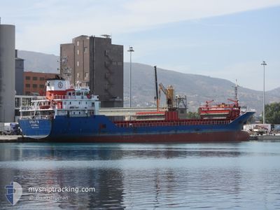
UGURS
General Cargo
Current Trip
| Time Travelled | 4 days |
|---|---|
| Remaining Time | --- |
| Distance Travelled | 855.77 nm |
| Remaining Distance | --- |
| AVG Speed | 7.9 Noeuds |
| MAX Speed | 9.6 Noeuds |
| AVG Wind | 10.8 knots |
| MAX Wind | 30.3 knots |
| MIN Temp | 9.7°C / 49.46°F |
| MAX Temp | 17.6°C / 63.68°F |
| Tirant d eau | 5.9 m |
| Position reçue | 33 m depuis |
Current Position
| Longitude | --- |
|---|---|
| Latitude | --- |
| Etat | Under way using engine |
| Vitesse | 8.8 Noeuds |
| Parcours | 49.1° |
| Zone | Aegean Sea |
| Station | T-AIS |
| Position reçue | 33 m depuis |
Info
Information
The current position of UGURS is in Aegean Sea with coordinates 37.54045° / 25.28952° as reported on 2025-12-07 09:30 by AIS to our vessel tracker app. The vessel's current speed is 8.8 Noeuds and is heading at the port of ALIAGA. The estimated time of arrival as calculated by MyShipTracking vessel tracking app is 2025-12-08 05:45 LT
The vessel UGURS (IMO: 9539793, MMSI: 271040150) is a General Cargo that was built in 2010 ( 15 Age ). It's sailing under the flag of [TR] Turkey.
In this page you can find informations about the vessels current position, last detected port calls, and current voyage information. If the vessels is not in coverage by AIS you will find the latest position.
The current position of UGURS is detected by our AIS receivers and we are not responsible for the reliability of the data. The last position was recorded while the vessel was in Coverage by the Ais receivers of our vessel tracking app.
The current draught of UGURS as reported by AIS is 5.9 meters
Weather
| Temperature | 16.4°C / 61.52°F |
|---|---|
| Wind Speed | 11 knots |
| Direction | 339° NNW |
| Pressure | 1008.8 hPa |
| Humidity | 73.8 % |
| Cloud Coverage | 21 % |
Featured Company
Last Port Calls
| Port | Arrival | Departure | Time In Port |
|---|---|---|---|
| 2025-11-29 08:08 | 2025-12-02 21:57 | 3 d | |
| 2025-11-27 21:23 | 2025-11-28 13:12 | 15 h | |
| 2025-11-19 07:20 | 2025-11-21 17:21 | 2 d | |
| 2025-11-07 23:48 | 2025-11-13 16:09 | 5 d | |
| 2025-11-03 07:17 | 2025-11-06 07:36 | 3 d | |
| 2025-10-27 08:20 | 2025-10-30 12:23 | 3 d | |
| 2025-10-17 08:09 | 2025-10-21 09:02 | 4 d | |
| 2025-10-16 03:04 | 2025-10-16 16:39 | 13 h | |
| 2025-10-13 08:04 | 2025-10-15 13:56 | 2 d | |
| 2025-10-01 08:52 | 2025-10-05 04:56 | 3 d |
Last Trips
| Origin | Departure | Destination | Arrival | Distance | |
|---|---|---|---|---|---|
| 2025-11-28 13:12 | 2025-11-29 08:08 | 108.98 nm | |||
| 2025-11-21 17:21 | 2025-11-27 21:23 | 111.92 nm | |||
| 2025-11-13 16:09 | 2025-11-19 07:20 | 1184.84 nm | |||
| 2025-11-06 07:36 | 2025-11-07 23:48 | 289.18 nm | |||
| 2025-10-30 12:23 | 2025-11-03 07:17 | 212.87 nm | |||
| 2025-10-21 09:02 | 2025-10-27 08:20 | 894.43 nm | |||
| 2025-10-16 16:39 | 2025-10-17 08:09 | 40.01 nm | |||
| 2025-10-15 13:56 | 2025-10-16 03:04 | 104.79 nm | |||
| 2025-10-05 04:56 | 2025-10-13 08:04 | 1115.18 nm | |||
| 2025-09-26 17:47 | 2025-10-01 08:52 | 328.00 nm |
Events
| Heure | Evenement | Détails | Position/ Destination | Info |
|---|---|---|---|---|
| 2025-12-07 09:38 | Etat Changé | Default Under way using engine |
37.55456 / 25.30996
TR ALI
|
Vitesse: 8.8 kn Parcours: 49.1° |
| 2025-12-07 03:34 | Etat Changé | Under way using engine Default |
37.03107 / 24.48249
TR ALI
|
Vitesse: 8.3 kn Parcours: 57° |
| 2025-12-07 03:31 | Etat Changé | Default Under way using engine |
37.02781 / 24.47646
TR ALI
|
Vitesse: 8.2 kn Parcours: 55° |
| 2025-12-07 00:56 | Changement de destination | TR ALI TRIZM |
36.82734 / 24.09549
TR ALI
|
Vitesse: 8 kn Parcours: 59.3° |
| 2025-12-07 00:56 | Changement d'ETA | 2025/12/08 02:45 2025/12/06 20:00 |
36.82734 / 24.09549
TR ALI
|
Vitesse: 8 kn Parcours: 59.3° |
| 2025-12-07 00:20 | Changement de zone | Greek part of the Aegean Sea Greek part of the Mediterranean Sea - Eastern Basin |
36.78986 / 24.01936
Aegean Sea
TRIZM
|
Vitesse: 8.1 kn Parcours: 60.5° |
| 2025-12-07 00:18 | Etat Changé | Under way using engine Default |
36.78796 / 24.01518
TRIZM
|
Vitesse: 8 kn Parcours: 56° |
| 2025-12-07 00:18 | Dans la zone couverte |
36.78986 / 24.01936
Aegean Sea
TRIZM
|
Vitesse: 8.1 kn Parcours: 60.5° |
|
| 2025-12-06 17:14 | Etat Changé | Default Under way using engine |
36.39333 / 22.90667
TRIZM
|
Vitesse: 8.8 kn Parcours: 84° |
| 2025-12-06 16:49 | Hors de la zone couverte |
36.38819 / 22.83096
Mediterranean Sea - Eastern Basin
TRIZM
|
Vitesse: 8.8 kn Parcours: 84° |