
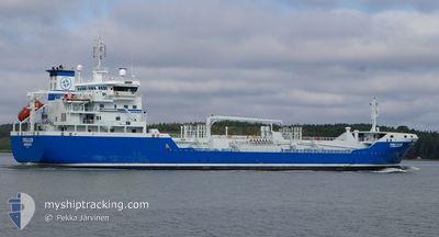
TELLUS
Oil/Chemical Tanker
Current Trip
| Trip Time | 4 h, 22 mins |
|---|---|
| Trip Distance | 48.95 nm |
| AVG Speed | 11.6 Noeuds |
| MAX Speed | 13.2 Noeuds |
| Tirant d eau | 6.6 m |
| AVG Wind | 9.1 knots |
| MAX Wind | 10 knots |
| MIN Temp | -0.4°C / 31.28°F |
| MAX Temp | 1.2°C / 34.16°F |
| Position reçue | 3 h, 4 m depuis |
Current Position
| Longitude | 17.06888° |
|---|---|
| Latitude | 59.52902° |
| Etat | Under way using engine |
| Vitesse | 10 Noeuds |
| Parcours | 268.6° |
| Zone | Baltic Sea |
| Station | T-AIS |
| Position reçue | 3 h, 4 m depuis |
Info
Information
The current position of TELLUS is in Baltic Sea with coordinates 59.52902° / 17.06888° as reported on 2024-04-17 02:07 by AIS to our vessel tracker app. The vessel's current speed is 10 Noeuds and is currently inside the port of VASTERAS.
The vessel TELLUS (IMO: 9321615, MMSI: 266471000) is a Oil/Chemical Tanker that was built in 2006 ( 18 Age ). It's sailing under the flag of [SE] Sweden.
In this page you can find informations about the vessels current position, last detected port calls, and current voyage information. If the vessels is not in coverage by AIS you will find the latest position.
The current position of TELLUS is detected by our AIS receivers and we are not responsible for the reliability of the data. The last position was recorded while the vessel was in Coverage by the Ais receivers of our vessel tracking app.
The current draught of TELLUS as reported by AIS is 6.6 meters
Weather
| Temperature | 0.7°C / 33.26°F |
|---|---|
| Wind Speed | 5 knots |
| Direction | 357° N |
| Pressure | 1006.6 hPa |
| Humidity | 87.8 % |
| Cloud Coverage | 39 % |
Featured Company
Last Port Calls
| Port | Arrival | Departure | Time In Port |
|---|---|---|---|
| 2024-04-17 03:59 | |||
| 2024-04-16 23:13 | 2024-04-16 23:37 | 24 m | |
| 2024-04-14 17:52 | 2024-04-15 22:09 | 1 d | |
| 2024-04-13 14:34 | 2024-04-14 04:14 | 13 h | |
| 2024-04-12 12:16 | 2024-04-13 08:00 | 19 h | |
| 2024-04-10 11:46 | 2024-04-12 05:05 | 1 d | |
| 2024-04-08 09:35 | 2024-04-10 04:43 | 1 d | |
| 2024-04-04 17:57 | 2024-04-04 18:44 | 46 m | |
| 2024-04-03 23:13 | 2024-04-04 13:45 | 14 h | |
| 2024-04-03 06:05 | 2024-04-03 18:56 | 12 h |
Last Trips
| Origin | Departure | Destination | Arrival | Distance | |
|---|---|---|---|---|---|
| 2024-04-17 01:37 | 2024-04-17 05:59 | 48.95 nm | |||
| 2024-04-16 01:09 | 2024-04-17 01:13 | 302.15 nm | |||
| 2024-04-14 07:14 | 2024-04-14 20:52 | 89.53 nm | |||
| 2024-04-13 11:00 | 2024-04-13 17:34 | 82.50 nm | |||
| 2024-04-12 08:05 | 2024-04-12 15:16 | 85.14 nm | |||
| 2024-04-10 07:43 | 2024-04-10 14:46 | 83.70 nm | |||
| 2024-04-04 20:44 | 2024-04-08 12:35 | 305.38 nm | |||
| 2024-04-04 15:45 | 2024-04-04 19:57 | 48.23 nm | |||
| 2024-04-03 20:56 | 2024-04-04 01:13 | 48.35 nm | |||
| 2024-04-02 07:39 | 2024-04-03 08:05 | 300.61 nm |
Events
| Heure | Evenement | Détails | Position/ Destination | Info |
|---|---|---|---|---|
| 2024-04-17 04:19 | Arret |
59.59329 / 16.52712
[SE] VASTERAS
|
Vitesse: 0.3 kn Parcours: 341° |
|
| 2024-04-17 03:59 | Port d'arrivée |
|
59.58740 / 16.55438
[SE] VASTERAS
|
Vitesse: 12.9 kn Parcours: 349° |
| 2024-04-17 02:12 | Etat Changé | Default Under way using engine |
59.52873 / 17.04478
VASTERAS
|
Vitesse: 10 kn Parcours: 268.6° |
| 2024-04-17 02:07 | Hors de la zone couverte |
59.52902 / 17.06888
Baltic Sea
VASTERAS
|
Vitesse: 10 kn Parcours: 268.6° |
|
| 2024-04-17 02:04 | Etat Changé | Under way using engine Default |
59.52932 / 17.08627
VASTERAS
|
Vitesse: 12.9 kn Parcours: 301° |
| 2024-04-17 01:52 | Etat Changé | Default Under way using engine |
59.51722 / 17.16795
VASTERAS
|
Vitesse: 13 kn Parcours: 301.8° |
| 2024-04-17 00:00 | Etat Changé | Under way using engine Default |
59.24043 / 17.59592
VASTERAS
|
Vitesse: 8.1 kn Parcours: 346° |
| 2024-04-16 23:56 | Etat Changé | Default Under way using engine |
59.23043 / 17.60505
VASTERAS
|
Vitesse: 5.7 kn Parcours: 3.2° |
| 2024-04-16 23:37 | PORT DE DEPART |
|
59.20337 / 17.62468
VASTERAS
|
Vitesse: 4.7 kn Parcours: 334° |
| 2024-04-16 23:28 | Démarrage |
59.19462 / 17.63198
[SE] SODERTALJE
|
Vitesse: 3.1 kn Parcours: 354° |