
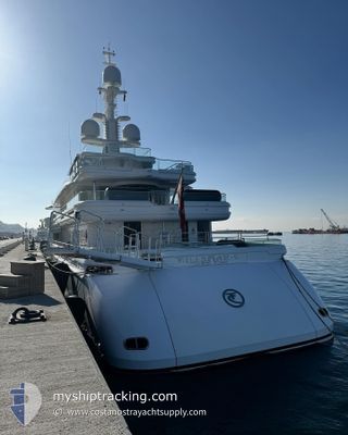
TALISMAN C
Yacht
Current Trip
| Time Travelled | 3 days |
|---|---|
| Remaining Time | 32 mins |
| Distance Travelled | 1071.99 nm |
| Remaining Distance | 7.16 nm |
| AVG Speed | 11.6 Noeuds |
| MAX Speed | 13.6 Noeuds |
| AVG Wind | 5.6 knots |
| MAX Wind | 21.9 knots |
| MIN Temp | 13.9°C / 57.02°F |
| MAX Temp | 24.5°C / 76.1°F |
| Tirant d eau | 4.2 m |
| Position reçue | 1 m depuis |
Current Position
| Longitude | 14.48033° |
|---|---|
| Latitude | 35.98733° |
| Etat | Under way using engine |
| Vitesse | 12.8 Noeuds |
| Parcours | 144° |
| Zone | Mediterranean Sea - Eastern Basin |
| Station | T-AIS |
| Position reçue | 1 m depuis |
Info
Information
The current position of TALISMAN C is in Mediterranean Sea - Eastern Basin with coordinates 35.98733° / 14.48033° as reported on 2024-04-19 06:02 by AIS to our vessel tracker app. The vessel's current speed is 12.8 Noeuds and is heading at the port of VALLETTA. The estimated time of arrival as calculated by MyShipTracking vessel tracking app is 2024-04-19 06:35 LT
The vessel TALISMAN C (IMO: 1011070, MMSI: 319027500) is a Yacht that was built in 2011 ( 13 Age ). It's sailing under the flag of [KY] Cayman Is.
In this page you can find informations about the vessels current position, last detected port calls, and current voyage information. If the vessels is not in coverage by AIS you will find the latest position.
The current position of TALISMAN C is detected by our AIS receivers and we are not responsible for the reliability of the data. The last position was recorded while the vessel was in Coverage by the Ais receivers of our vessel tracking app.
The current draught of TALISMAN C as reported by AIS is 4.2 meters
Weather
| Temperature | 13.9°C / 57.02°F |
|---|---|
| Wind Speed | 21 knots |
| Direction | 279° W |
| Pressure | 1013 hPa |
| Humidity | 82.3 % |
| Cloud Coverage | 50 % |
Featured Company
Last Port Calls
| Port | Arrival | Departure | Time In Port |
|---|---|---|---|
| 2024-04-15 06:17 | 2024-04-15 11:35 | 5 h | |
| 2024-03-10 13:23 | 2024-03-31 19:40 | 21 d | |
| 2024-02-26 15:57 | 2024-03-09 20:43 | 12 d |
Last Trips
| Origin | Departure | Destination | Arrival | Distance | |
|---|---|---|---|---|---|
| 2024-03-31 15:40 | 2024-04-15 08:17 | 4209.47 nm | |||
| 2024-03-09 15:43 | 2024-03-10 09:23 | 69.14 nm | |||
| 2024-01-30 09:45 | 2024-02-26 10:57 | 2321.75 nm |
Events
| Heure | Evenement | Détails | Position/ Destination | Info |
|---|---|---|---|---|
| 2024-04-19 03:44 | Changement de zone | Maltese part of the Mediterranean Sea - Eastern Basin Spanish part of the Mediterranean Sea - Western Basin |
36.25883 / 14.06767
Mediterranean Sea - Eastern Basin
MALTA
|
Vitesse: 11.2 kn Parcours: 124° |
| 2024-04-19 03:44 | Dans la zone couverte |
36.25883 / 14.06767
Mediterranean Sea - Eastern Basin
MALTA
|
Vitesse: 11.2 kn Parcours: 124° |
|
| 2024-04-17 14:14 | Hors de la zone couverte |
39.78217 / 4.25050
Mediterranean Sea - Western Basin
MALTA
|
Vitesse: 13.2 kn Parcours: 97° |
|
| 2024-04-17 14:14 | Changement de zone | Spanish part of the Mediterranean Sea - Western Basin Spanish part of the Balearic Sea |
39.78217 / 4.25050
Mediterranean Sea - Western Basin
MALTA
|
Vitesse: 13.2 kn Parcours: 97° |
| 2024-04-17 13:45 | Detecté en mer | Spanish part of the Balearic Sea |
39.77950 / 4.11433
Balearic Sea
MALTA
|
Vitesse: 13.1 kn Parcours: 94° |
| 2024-04-17 13:45 | Dans la zone couverte |
39.77950 / 4.11433
Balearic Sea
MALTA
|
Vitesse: 13.1 kn Parcours: 94° |
|
| 2024-04-17 03:26 | Hors de la zone couverte |
38.49317 / 2.17617
Mediterranean Sea - Western Basin
MALTA
|
Vitesse: 11.4 kn Parcours: 58° |
|
| 2024-04-17 02:16 | Dans la zone couverte |
38.37716 / 1.93800
Mediterranean Sea - Western Basin
MALTA
|
Vitesse: 10.9 kn Parcours: 60° |
|
| 2024-04-17 00:42 | Hors de la zone couverte |
38.22816 / 1.63317
Mediterranean Sea - Western Basin
MALTA
|
Vitesse: 11 kn Parcours: 60° |
|
| 2024-04-17 00:33 | Dans la zone couverte |
38.21417 / 1.60250
Mediterranean Sea - Western Basin
MALTA
|
Vitesse: 11 kn Parcours: 60° |