
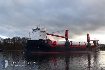
FWN SEA
Cargo
Current Trip
| Time Travelled | 3 days |
|---|---|
| Remaining Time | --- |
| Distance Travelled | 74.54 nm |
| Remaining Distance | --- |
| AVG Speed | 12.6 Noeuds |
| MAX Speed | 13.7 Noeuds |
| AVG Wind | 15.2 knots |
| MAX Wind | 19.8 knots |
| MIN Temp | 29.6°C / 85.28°F |
| MAX Temp | 31.2°C / 88.16°F |
| Tirant d eau | 5.2 m |
| Position reçue | 4 h, 52 m depuis |
Current Position
| Longitude | 100.77875° |
|---|---|
| Latitude | 13.09820° |
| Etat | At anchor |
| Vitesse | 0.1 Noeuds |
| Parcours | 152° |
| Zone | Gulf of Thailand |
| Station | T-AIS |
| Position reçue | 4 h, 52 m depuis |
Info
Information
The current position of FWN SEA is in Gulf of Thailand with coordinates 13.09820° / 100.77875° as reported on 2024-04-23 15:38 by AIS to our vessel tracker app. The vessel's current speed is 0.1 Noeuds
The vessel FWN SEA (IMO: 9721657, MMSI: 244770273) is a Cargo It's sailing under the flag of [NL] Netherlands.
In this page you can find informations about the vessels current position, last detected port calls, and current voyage information. If the vessels is not in coverage by AIS you will find the latest position.
The current position of FWN SEA is detected by our AIS receivers and we are not responsible for the reliability of the data. The last position was recorded while the vessel was in Coverage by the Ais receivers of our vessel tracking app.
The current draught of FWN SEA as reported by AIS is 5.2 meters
Weather
| Temperature | 30.1°C / 86.18°F |
|---|---|
| Wind Speed | 14 knots |
| Direction | 186° S |
| Pressure | 1005 hPa |
| Humidity | 72.1 % |
| Cloud Coverage | 97 % |
Featured Company
Last Port Calls
| Port | Arrival | Departure | Time In Port |
|---|---|---|---|
| 2024-04-20 00:48 | 2024-04-20 12:36 | 11 h | |
| 2024-04-15 15:47 | 2024-04-16 19:39 | 1 d | |
| 2024-04-06 04:00 | 2024-04-12 01:14 | 5 d | |
| 2024-03-26 07:43 | 2024-04-06 02:23 | 10 d | |
| 2024-03-17 06:20 | 2024-03-26 06:23 | 9 d |
Last Trips
| Origin | Departure | Destination | Arrival | Distance | |
|---|---|---|---|---|---|
| 2024-04-17 03:39 | 2024-04-20 07:48 | 962.95 nm | |||
| 2024-04-12 09:14 | 2024-04-15 23:47 | 237.18 nm | |||
| 2024-04-06 10:23 | 2024-04-06 12:00 | 10.16 nm | |||
| 2024-03-26 14:23 | 2024-03-26 15:43 | 10.15 nm | |||
| 2023-12-20 09:14 | 2024-03-17 14:20 | 85.16 nm |
Events
| Heure | Evenement | Détails | Position/ Destination | Info |
|---|---|---|---|---|
| 2024-04-23 15:47 | Etat Changé | Default At anchor |
13.09823 / 100.77846
TH LCH
|
Vitesse: 0.1 kn Parcours: 152° |
| 2024-04-23 15:38 | Etat Changé | At anchor Default |
13.09820 / 100.77875
TH LCH
|
Vitesse: 0.2 kn Parcours: 153° |
| 2024-04-23 15:38 | Hors de la zone couverte |
13.09820 / 100.77875
Gulf of Thailand
|
Vitesse: 0.1 kn Parcours: 134.2° |
|
| 2024-04-23 15:35 | Etat Changé | Default At anchor |
13.09823 / 100.77858
TH LCH
|
Vitesse: 0.1 kn Parcours: 182° |
| 2024-04-23 15:29 | Etat Changé | At anchor Default |
13.09815 / 100.77840
TH LCH
|
Vitesse: 0.2 kn Parcours: 186° |
| 2024-04-23 15:20 | Etat Changé | Default At anchor |
13.09822 / 100.77865
TH LCH
|
Vitesse: 0.1 kn Parcours: 164° |
| 2024-04-23 15:14 | Etat Changé | At anchor Default |
13.09827 / 100.77870
TH LCH
|
Vitesse: Parcours: -1° |
| 2024-04-23 14:56 | Etat Changé | Default At anchor |
13.09823 / 100.77862
TH LCH
|
Vitesse: Parcours: 128° |
| 2024-04-23 14:50 | Etat Changé | At anchor Default |
13.09823 / 100.77857
TH LCH
|
Vitesse: Parcours: -1° |
| 2024-04-23 14:42 | Etat Changé | Default At anchor |
13.09833 / 100.77834
TH LCH
|
Vitesse: Parcours: 116° |