
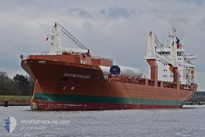
SUOMIGRACHT
General Cargo
Current Trip
| Time Travelled | 22 h, 38 mins |
|---|---|
| Remaining Time | 1 h, 13 mins |
| Distance Travelled | 361.91 nm |
| Remaining Distance | 19.77 nm |
| AVG Speed | 15.9 Noeuds |
| MAX Speed | 18 Noeuds |
| AVG Wind | 27.1 knots |
| MAX Wind | 30.9 knots |
| MIN Temp | 4.7°C / 40.46°F |
| MAX Temp | 8.1°C / 46.58°F |
| Tirant d eau | 9.2 m |
| Position reçue | Maintenant |
Current Position
| Longitude | 6.39252° |
|---|---|
| Latitude | 53.61528° |
| Etat | Under way using engine |
| Vitesse | 13.9 Noeuds |
| Parcours | 85.4° |
| Zone | North Sea |
| Station | T-AIS |
| Position reçue | Maintenant |
Info
Information
The current position of SUOMIGRACHT is in North Sea with coordinates 53.61528° / 6.39252° as reported on 2024-04-19 13:07 by AIS to our vessel tracker app. The vessel's current speed is 13.9 Noeuds and is heading at the port of EEMSHAVEN. The estimated time of arrival as calculated by MyShipTracking vessel tracking app is 2024-04-19 14:21 LT
The vessel SUOMIGRACHT (IMO: 9288057, MMSI: 246100000) is a General Cargo that was built in 2004 ( 20 Age ). It's sailing under the flag of [NL] Netherlands.
In this page you can find informations about the vessels current position, last detected port calls, and current voyage information. If the vessels is not in coverage by AIS you will find the latest position.
The current position of SUOMIGRACHT is detected by our AIS receivers and we are not responsible for the reliability of the data. The last position was recorded while the vessel was in Coverage by the Ais receivers of our vessel tracking app.
The current draught of SUOMIGRACHT as reported by AIS is 9.2 meters
Weather
| Temperature | 8°C / 46.4°F |
|---|---|
| Wind Speed | 30 knots |
| Direction | 317° NW |
| Pressure | 1004.3 hPa |
| Humidity | 76.5 % |
| Cloud Coverage | 58 % |
Featured Company
Last Port Calls
| Port | Arrival | Departure | Time In Port |
|---|---|---|---|
| 2024-04-12 23:48 | 2024-04-18 14:30 | 5 d | |
| 2024-04-09 10:35 | 2024-04-11 14:38 | 2 d | |
| 2024-03-26 03:04 | 2024-03-29 11:13 | 3 d | |
| 2024-03-21 23:42 | 2024-03-26 02:16 | 4 d | |
| 2024-03-20 22:31 | 2024-03-20 22:49 | 17 m | |
| 2024-03-09 04:38 | 2024-03-09 19:30 | 14 h | |
| 2024-03-02 14:45 | 2024-03-07 10:20 | 4 d | |
| 2024-02-25 23:45 | 2024-02-28 15:26 | 2 d | |
| 2024-02-24 10:39 | 2024-02-24 20:29 | 9 h | |
| 2024-02-17 12:18 | 2024-02-19 16:15 | 2 d |
Most Visited Ports (Last year)
| Port | Arrivals | |
|---|---|---|
| 5 | ||
| 4 | ||
| 3 | ||
| 3 | ||
| 2 | ||
| 2 |
Last Trips
| Origin | Departure | Destination | Arrival | Distance | |
|---|---|---|---|---|---|
| 2024-04-11 16:38 | 2024-04-13 01:48 | 561.14 nm | |||
| 2024-03-29 07:13 | 2024-04-09 12:35 | 3700.81 nm | |||
| 2024-03-25 22:16 | 2024-03-25 23:04 | 4.89 nm | |||
| 2024-03-20 18:49 | 2024-03-21 19:42 | 1.25 nm | |||
| 2024-03-09 20:30 | 2024-03-20 18:31 | 3729.37 nm | |||
| 2024-03-07 11:20 | 2024-03-09 05:38 | 395.82 nm | |||
| 2024-02-28 17:26 | 2024-03-02 15:45 | 870.60 nm | |||
| 2024-02-24 22:29 | 2024-02-26 01:45 | 397.69 nm | |||
| 2024-02-19 17:15 | 2024-02-24 12:39 | 1712.48 nm | |||
| 2024-01-29 18:32 | 2024-02-17 13:18 | 4490.39 nm |
Events
| Heure | Evenement | Détails | Position/ Destination | Info |
|---|---|---|---|---|
| 2024-04-19 12:35 | Changement de zone | Dutch part of the North Sea German part of the North Sea |
53.73335 / 6.33524
North Sea
NLEEM
|
Vitesse: 14.8 kn Parcours: 180.7° |
| 2024-04-19 09:08 | Dans la zone couverte |
54.61449 / 6.50035
North Sea
NLEEM
|
Vitesse: 16.2 kn Parcours: 186.6° |
|
| 2024-04-19 06:48 | Hors de la zone couverte |
55.23841 / 6.63194
North Sea
NLEEM
|
Vitesse: 15.5 kn Parcours: 209° |
|
| 2024-04-19 06:28 | Changement de zone | German part of the North Sea Danish part of the North Sea |
55.31667 / 6.68474
North Sea
NLEEM
|
Vitesse: 16.2 kn Parcours: 187.8° |
| 2024-04-18 22:14 | Changement de zone | Danish part of the North Sea Danish part of the Skaggerak |
57.21824 / 8.43024
North Sea
NLEEM
|
Vitesse: 16.1 kn Parcours: 213.9° |
| 2024-04-18 17:27 | Changement de destination | NLEEM GOTEBORG |
57.84766 / 10.55593
NLEEM
|
Vitesse: 16.5 kn Parcours: 265.8° |
| 2024-04-18 16:38 | Changement de zone | Danish part of the Skaggerak Danish part of the Kattegat |
57.80825 / 10.94300
Skaggerak
GOTEBORG
|
Vitesse: 17.2 kn Parcours: 316.2° |
| 2024-04-18 16:14 | Changement de zone | Danish part of the Kattegat Swedish part of the Kattegat |
57.74553 / 11.11468
Kattegat
GOTEBORG
|
Vitesse: 16.7 kn Parcours: 300° |
| 2024-04-18 14:30 | PORT DE DEPART |
|
57.67977 / 11.81267
GOTEBORG
|
Vitesse: 12.6 kn Parcours: 245° |
| 2024-04-18 14:14 | Démarrage |
57.68815 / 11.84442
[SE] GOTEBORG
|
Vitesse: 3.1 kn Parcours: 305° |