
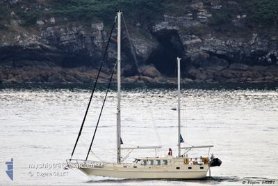
STRUMPET
Sailing
Current Trip
Unknown
| Time Travelled | 1 day |
|---|---|
| Remaining Time | --- |
| Distance Travelled | 11.72 nm |
| Remaining Distance | --- |
| AVG Speed | 4.3 Noeuds |
| MAX Speed | 6.1 Noeuds |
| AVG Wind | 8.9 knots |
| MAX Wind | 14.5 knots |
| MIN Temp | 6.5°C / 43.7°F |
| MAX Temp | 11.3°C / 52.34°F |
| Tirant d eau | 1.5 m |
| Position reçue | 1 m depuis |
Current Position
| Longitude | -4.19364° |
|---|---|
| Latitude | 50.33303° |
| Etat | Default |
| Vitesse | 0.1 Noeuds |
| Parcours | --- |
| Zone | English Channel |
| Station | T-AIS |
| Position reçue | 1 m depuis |
Info
Information
The current position of STRUMPET is in English Channel with coordinates 50.33303° / -4.19364° as reported on 2024-04-25 14:04 by AIS to our vessel tracker app. The vessel's current speed is 0.1 Noeuds
The vessel STRUMPET (MMSI: 235014017) is a Sailing It's sailing under the flag of [GB] United Kingdom.
In this page you can find informations about the vessels current position, last detected port calls, and current voyage information. If the vessels is not in coverage by AIS you will find the latest position.
The current position of STRUMPET is detected by our AIS receivers and we are not responsible for the reliability of the data. The last position was recorded while the vessel was in Coverage by the Ais receivers of our vessel tracking app.
The current draught of STRUMPET as reported by AIS is 1.5 meters
Weather
| Temperature | 11°C / 51.8°F |
|---|---|
| Wind Speed | 14 knots |
| Direction | 255° WSW |
| Pressure | 1004.6 hPa |
| Humidity | 80.3 % |
| Cloud Coverage | 100 % |
Featured Company
Last Trips
| Origin | Departure | Destination | Arrival | Distance |
|---|
Events
| Heure | Evenement | Détails | Position/ Destination | Info |
|---|---|---|---|---|
| 2024-04-25 13:49 | Arret | 2.36 nm, South West of PLYMOUTH |
50.33309 / -4.19375
|
Vitesse: 0.1 kn Parcours: 511° |
| 2024-04-25 12:25 | Démarrage | 3.79 nm, South East of PLYMOUTH |
50.31268 / -4.09488
|
Vitesse: 3.5 kn Parcours: 160.7° |
| 2024-04-24 14:50 | Arret | 3.67 nm, South East of PLYMOUTH |
50.31484 / -4.09568
|
Vitesse: 0.2 kn Parcours: 511° |
| 2024-04-24 12:20 | PORT DE DEPART |
|
50.35729 / -4.16706
|
Vitesse: 4.7 kn Parcours: 156.8° |
| 2024-04-24 12:16 | Démarrage |
50.36218 / -4.16755
[GB] PLYMOUTH
|
Vitesse: 4.4 kn Parcours: 207.7° |
|
| 2024-04-23 20:56 | Dans la zone couverte |
50.36434 / -4.16630
English Channel
[GB] PLYMOUTH
|
Vitesse: Parcours: 511° |
|
| 2024-04-16 14:06 | Hors de la zone couverte |
50.36429 / -4.16633
English Channel
[GB] PLYMOUTH
|
Vitesse: 0.1 kn Parcours: 511° |
|
| 2024-04-16 13:42 | Dans la zone couverte |
50.36431 / -4.16634
English Channel
[GB] PLYMOUTH
|
Vitesse: Parcours: 511° |