
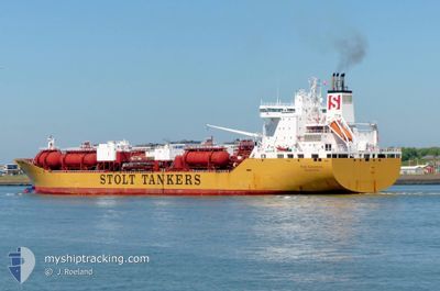
STOLT INNOVATION
Oil/Chemical Tanker
Current Trip
MYPKG
| Time Travelled | 2 days |
|---|---|
| Remaining Time | --- |
| Distance Travelled | 616.77 nm |
| Remaining Distance | --- |
| AVG Speed | 14.4 Noeuds |
| MAX Speed | 16.1 Noeuds |
| AVG Wind | 10.2 knots |
| MAX Wind | 19 knots |
| MIN Temp | 26.3°C / 79.34°F |
| MAX Temp | 28.3°C / 82.94°F |
| Tirant d eau | 10.4 m |
| Position reçue | 3 d depuis |
Current Position
| Longitude | --- |
|---|---|
| Latitude | --- |
| Etat | Under way using engine |
| Vitesse | 10.2 Noeuds |
| Parcours | 307.2° |
| Zone | Malacca Strait |
| Station | T-AIS |
| Position reçue | 3 d depuis |
Info
Information
The current position of STOLT INNOVATION is in Malacca Strait with coordinates 2.19564° / 101.99035° as reported on 2025-12-06 00:05 by AIS to our vessel tracker app. The vessel's current speed is 10.2 Noeuds
The vessel STOLT INNOVATION (IMO: 9102069, MMSI: 319489000) is a Oil/Chemical Tanker that was built in 1996 ( 29 Age ). It's sailing under the flag of [KY] Cayman Is.
In this page you can find informations about the vessels current position, last detected port calls, and current voyage information. If the vessels is not in coverage by AIS you will find the latest position.
The current position of STOLT INNOVATION is detected by our AIS receivers and we are not responsible for the reliability of the data. The last position was recorded while the vessel was in Coverage by the Ais receivers of our vessel tracking app.
The current draught of STOLT INNOVATION as reported by AIS is 10.4 meters
Weather
| Temperature | 27.8°C / 82.04°F |
|---|---|
| Wind Speed | 15 knots |
| Direction | 44° NE |
| Pressure | 1008.5 hPa |
| Humidity | 72.7 % |
| Cloud Coverage | 87 % |
Featured Company
Last Port Calls
| Port | Arrival | Departure | Time In Port |
|---|---|---|---|
| 2025-12-06 23:05 | 2025-12-07 19:08 | 20 h | |
| 2025-12-04 22:25 | 2025-12-05 16:50 | 18 h | |
| 2025-12-02 17:44 | 2025-12-04 10:57 | 1 d | |
| 2025-11-30 14:05 | 2025-12-01 05:28 | 15 h | |
| 2025-11-27 03:41 | 2025-11-29 22:12 | 2 d | |
| 2025-11-21 12:44 | 2025-11-22 02:04 | 13 h | |
| 2025-11-20 03:34 | 2025-11-20 15:34 | 12 h | |
| 2025-11-18 09:36 | 2025-11-19 08:02 | 22 h | |
| 2025-11-14 08:54 | 2025-11-15 20:24 | 1 d | |
| 2025-11-11 10:16 | 2025-11-13 11:16 | 2 d |
Most Visited Ports (Last year)
| Port | Arrivals | |
|---|---|---|
| 10 | ||
| 7 | ||
| 6 | ||
| 4 | ||
| 3 | ||
| 3 |
Last Trips
| Origin | Departure | Destination | Arrival | Distance | |
|---|---|---|---|---|---|
| 2025-12-05 16:50 | 2025-12-06 23:05 | 247.98 nm | |||
| 2025-12-04 10:57 | 2025-12-04 22:25 | 35.40 nm | |||
| 2025-12-01 05:28 | 2025-12-02 17:44 | 465.86 nm | |||
| 2025-11-29 22:12 | 2025-11-30 14:05 | 161.65 nm | |||
| 2025-11-22 02:04 | 2025-11-27 03:41 | 415.66 nm | |||
| 2025-11-20 15:34 | 2025-11-21 12:44 | 18.92 nm | |||
| 2025-11-19 08:02 | 2025-11-20 03:34 | 52.54 nm | |||
| 2025-11-15 20:24 | 2025-11-18 09:36 | 766.28 nm | |||
| 2025-11-13 11:16 | 2025-11-14 08:54 | 13.38 nm | |||
| 2025-11-01 06:29 | 2025-11-11 10:16 | 2055.54 nm |
Events
| Heure | Evenement | Détails | Position/ Destination | Info |
|---|---|---|---|---|
| 2025-12-08 06:57 | Démarrage | 15.03 nm, South of PORT KLANG |
2.74859 / 101.32275
MYPKG
|
Vitesse: 11.6 kn Parcours: 242° |
| 2025-12-07 12:37 | Arret | 14.31 nm, South of PORT KLANG |
2.75989 / 101.33257
MYPKG
|
Vitesse: 0.2 kn Parcours: 332° |
| 2025-12-07 11:08 | PORT DE DEPART |
|
2.90646 / 101.26685
MYPKG
|
Vitesse: 14.4 kn Parcours: 219° |
| 2025-12-07 10:45 | Démarrage |
2.97335 / 101.31487
[MY] PORT KLANG
|
Vitesse: 5.9 kn Parcours: 234° |
|
| 2025-12-06 16:19 | Arret |
2.97543 / 101.31995
[MY] PORT KLANG
|
Vitesse: Parcours: 219° |
|
| 2025-12-06 15:05 | Port d'arrivée |
|
2.91476 / 101.27668
[MY] PORT KLANG
|
Vitesse: 10.7 kn Parcours: 36° |
| 2025-12-06 13:17 | Démarrage | 17.18 nm, South West of PORT KLANG |
2.80879 / 101.13164
MYPKG
|
Vitesse: 3.3 kn Parcours: 137° |
| 2025-12-06 09:05 | Arret | 17.05 nm, South West of PORT KLANG |
2.82054 / 101.12463
MYPKG
|
Vitesse: 0.3 kn Parcours: 327° |
| 2025-12-06 00:13 | Etat Changé | Default Under way using engine |
2.20795 / 101.97347
MYPKG
|
Vitesse: 10.2 kn Parcours: 307.2° |
| 2025-12-06 00:05 | Hors de la zone couverte |
2.19564 / 101.99035
Malacca Strait
MYPKG
|
Vitesse: 10.2 kn Parcours: 307.2° |