
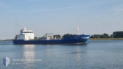
STELLA POLARIS
Oil/Chemical Tanker
Current Trip
| Trip Time | 2 days |
|---|---|
| Trip Distance | 726.11 nm |
| AVG Speed | 9.4 Noeuds |
| MAX Speed | 12.8 Noeuds |
| Tirant d eau | 7 m |
| AVG Wind | 10.2 knots |
| MAX Wind | 19.6 knots |
| MIN Temp | 0.8°C / 33.44°F |
| MAX Temp | 5°C / 41°F |
| Position reçue | 12 h, 17 m depuis |
Current Position
| Longitude | 19.03627° |
|---|---|
| Latitude | 60.41642° |
| Etat | Under way using engine |
| Vitesse | 12.4 Noeuds |
| Parcours | 5.3° |
| Zone | Gulf of Bothnia |
| Station | T-AIS |
| Position reçue | 12 h, 17 m depuis |
Info
Information
The current position of STELLA POLARIS is in Gulf of Bothnia with coordinates 60.41642° / 19.03627° as reported on 2024-04-24 11:54 by AIS to our vessel tracker app. The vessel's current speed is 12.4 Noeuds and is currently inside the port of PORI.
The vessel STELLA POLARIS (IMO: 9187057, MMSI: 245911000) is a Oil/Chemical Tanker that was built in 1999 ( 25 Age ). It's sailing under the flag of [NL] Netherlands.
In this page you can find informations about the vessels current position, last detected port calls, and current voyage information. If the vessels is not in coverage by AIS you will find the latest position.
The current position of STELLA POLARIS is detected by our AIS receivers and we are not responsible for the reliability of the data. The last position was recorded while the vessel was in Coverage by the Ais receivers of our vessel tracking app.
The current draught of STELLA POLARIS as reported by AIS is 7 meters
Weather
| Temperature | -0.6°C / 30.92°F |
|---|---|
| Wind Speed | 8 knots |
| Direction | 119° ESE |
| Pressure | 1012.2 hPa |
| Humidity | 89.3 % |
| Cloud Coverage | 48 % |
Featured Company
Last Port Calls
| Port | Arrival | Departure | Time In Port |
|---|---|---|---|
| 2024-04-24 20:48 | |||
| 2024-04-22 02:16 | 2024-04-22 02:42 | 26 m | |
| 2024-04-19 23:25 | 2024-04-20 22:48 | 23 h | |
| 2024-04-17 12:54 | 2024-04-17 13:22 | 28 m | |
| 2024-04-10 18:50 | 2024-04-11 03:59 | 9 h | |
| 2024-04-09 13:13 | 2024-04-10 04:45 | 15 h | |
| 2024-04-06 17:36 | 2024-04-07 05:11 | 11 h | |
| 2024-04-01 18:21 | 2024-04-01 18:25 | 4 m | |
| 2024-03-29 06:04 | 2024-03-30 08:47 | 1 d | |
| 2024-03-25 07:31 | 2024-03-26 06:42 | 23 h |
Most Visited Ports (Last year)
| Port | Arrivals | |
|---|---|---|
| 17 | ||
| 13 | ||
| 12 | ||
| 7 | ||
| 7 | ||
| 3 |
Last Trips
| Origin | Departure | Destination | Arrival | Distance | |
|---|---|---|---|---|---|
| 2024-04-22 04:42 | 2024-04-24 23:48 | 726.11 nm | |||
| 2024-04-21 00:48 | 2024-04-22 04:16 | 276.65 nm | |||
| 2024-04-17 15:22 | 2024-04-20 01:25 | 219.21 nm | |||
| 2024-04-11 06:59 | 2024-04-17 14:54 | 1185.70 nm | |||
| 2024-04-10 06:45 | 2024-04-10 21:50 | 168.50 nm | |||
| 2024-04-07 07:11 | 2024-04-09 15:13 | 541.76 nm | |||
| 2024-04-01 20:25 | 2024-04-06 19:36 | 535.88 nm | |||
| 2024-03-30 09:47 | 2024-04-01 20:21 | 403.86 nm | |||
| 2024-03-26 08:42 | 2024-03-29 07:04 | 755.80 nm | |||
| 2024-03-20 11:15 | 2024-03-25 09:31 | 687.22 nm |
Events
| Heure | Evenement | Détails | Position/ Destination | Info |
|---|---|---|---|---|
| 2024-04-24 20:56 | Arret |
61.64087 / 21.40591
[FI] PORI
|
Vitesse: 0.2 kn Parcours: 274° |
|
| 2024-04-24 20:48 | Port d'arrivée |
|
61.64134 / 21.40428
[FI] PORI
|
Vitesse: 1.8 kn Parcours: 293° |
| 2024-04-24 12:01 | Etat Changé | Default Under way using engine |
60.43811 / 19.04052
NLRTM>>FIPOR
|
Vitesse: 12.4 kn Parcours: 5.3° |
| 2024-04-24 11:54 | Hors de la zone couverte |
60.41642 / 19.03627
Gulf of Bothnia
NLRTM>>FIPOR
|
Vitesse: 12.4 kn Parcours: 5.3° |
|
| 2024-04-24 10:53 | Changement de zone | Swedish part of the Gulf of Bothnia Finnish part of the Gulf of Bothnia |
60.20804 / 19.08869
Gulf of Bothnia
NLRTM>>FIPOR
|
Vitesse: 12.1 kn Parcours: 334.9° |
| 2024-04-24 08:11 | Changement de zone | Finnish part of the Gulf of Bothnia Finnish part of the Baltic Sea |
59.78860 / 19.76059
Gulf of Bothnia
NLRTM>>FIPOR
|
Vitesse: 12.1 kn Parcours: 321.2° |
| 2024-04-24 07:05 | Detecté en mer | Finnish part of the Baltic Sea |
59.62929 / 20.05005
Baltic Sea
NLRTM>>FIPOR
|
Vitesse: 11.9 kn Parcours: 310.3° |
| 2024-04-24 07:04 | Etat Changé | Under way using engine Default |
59.62890 / 20.05097
NLRTM>>FIPOR
|
Vitesse: 12 kn Parcours: 310° |
| 2024-04-24 07:04 | Dans la zone couverte |
59.62929 / 20.05005
Baltic Sea
NLRTM>>FIPOR
|
Vitesse: 11.9 kn Parcours: 310.3° |
|
| 2024-04-24 04:15 | Hors de la zone couverte |
59.15311 / 19.78033
Baltic Sea
NLRTM>>FIPOR
|
Vitesse: 12.1 kn Parcours: 34.4° |