
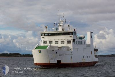
SKIFTET
Ro-Ro/Passenger Ship
Current Trip
KOKAR<>LANGNAS
| Time Travelled | 1 day |
|---|---|
| Remaining Time | --- |
| Distance Travelled | 67.66 nm |
| Remaining Distance | --- |
| AVG Speed | 12.1 Noeuds |
| MAX Speed | 12.5 Noeuds |
| AVG Wind | 18.6 knots |
| MAX Wind | 24.7 knots |
| MIN Temp | 5.2°C / 41.36°F |
| MAX Temp | 6.3°C / 43.34°F |
| Tirant d eau | 4 m |
| Position reçue | 3 d depuis |
Current Position
| Longitude | --- |
|---|---|
| Latitude | --- |
| Etat | Under way using engine |
| Vitesse | 12.2 Noeuds |
| Parcours | 106.9° |
| Zone | Gulf of Bothnia |
| Station | T-AIS |
| Position reçue | 3 d depuis |
Info
Information
The current position of SKIFTET is in Gulf of Bothnia with coordinates 59.96408° / 20.88331° as reported on 2025-12-06 17:39 by AIS to our vessel tracker app. The vessel's current speed is 12.2 Noeuds
The vessel SKIFTET (IMO: 8412807, MMSI: 230992740) is a Ro-Ro/Passenger Ship that was built in 1985 ( 40 Age ). It's sailing under the flag of [FI] Finland.
In this page you can find informations about the vessels current position, last detected port calls, and current voyage information. If the vessels is not in coverage by AIS you will find the latest position.
The current position of SKIFTET is detected by our AIS receivers and we are not responsible for the reliability of the data. The last position was recorded while the vessel was in Coverage by the Ais receivers of our vessel tracking app.
The current draught of SKIFTET as reported by AIS is 4 meters
Weather
| Temperature | 5.2°C / 41.36°F |
|---|---|
| Wind Speed | 15 knots |
| Direction | 318° NW |
| Pressure | 1004.8 hPa |
| Humidity | 93.3 % |
| Cloud Coverage | 100 % |
Featured Company
Last Port Calls
| Port | Arrival | Departure | Time In Port |
|---|---|---|---|
| 2025-12-08 08:56 | 2025-12-08 11:58 | 3 h | |
| 2025-12-07 16:27 | 2025-12-07 17:29 | 1 h | |
| 2025-12-04 09:17 | 2025-12-04 09:21 | 4 m | |
| 2025-12-03 11:28 | 2025-12-03 12:12 | 43 m | |
| 2025-12-02 09:12 | 2025-12-02 09:20 | 8 m | |
| 2025-11-30 09:20 | 2025-11-30 09:28 | 8 m | |
| 2025-11-29 10:01 | 2025-11-29 17:45 | 7 h | |
| 2025-11-28 09:07 | 2025-11-28 12:02 | 2 h | |
| 2025-11-26 18:52 | 2025-11-26 18:59 | 6 m | |
| 2025-11-26 17:21 | 2025-11-26 18:21 | 59 m |
Last Trips
| Origin | Departure | Destination | Arrival | Distance | |
|---|---|---|---|---|---|
| 2025-12-07 17:29 | 2025-12-08 08:56 | 43.79 nm | |||
| 2025-12-04 09:21 | 2025-12-07 16:27 | 177.62 nm | |||
| 2025-12-03 12:12 | 2025-12-04 09:17 | 69.67 nm | |||
| 2025-12-02 09:20 | 2025-12-03 11:28 | 88.97 nm | |||
| 2025-11-30 09:28 | 2025-12-02 09:12 | 122.01 nm | |||
| 2025-11-29 17:45 | 2025-11-30 09:20 | 39.19 nm | |||
| 2025-11-28 12:02 | 2025-11-29 10:01 | 82.48 nm | |||
| 2025-11-26 18:59 | 2025-11-28 09:07 | 88.18 nm | |||
| 2025-11-26 18:21 | 2025-11-26 18:52 | 5.81 nm | |||
| 2025-11-26 12:45 | 2025-11-26 17:21 | 39.01 nm |
Events
| Heure | Evenement | Détails | Position/ Destination | Info |
|---|---|---|---|---|
| 2025-12-08 09:58 | PORT DE DEPART |
|
60.11344 / 20.37114
KOKAR<>LANGNAS
|
Vitesse: Parcours: 24° |
| 2025-12-08 06:56 | Port d'arrivée |
|
60.11759 / 20.29716
[FI] LANGNAS
|
Vitesse: 11.8 kn Parcours: 221° |
| 2025-12-08 04:32 | Démarrage | 14.96 nm, South East of OVERO |
59.95265 / 20.89191
KOKAR<>LANGNAS
|
Vitesse: 11.5 kn Parcours: 334° |
| 2025-12-07 15:29 | PORT DE DEPART |
|
60.11337 / 20.31130
KOKAR<>LANGNAS
|
Vitesse: 6.4 kn Parcours: 107° |
| 2025-12-07 14:27 | Port d'arrivée |
|
60.11779 / 20.30001
[FI] LANGNAS
|
Vitesse: 12.3 kn Parcours: 265° |
| 2025-12-06 17:39 | Hors de la zone couverte |
59.96408 / 20.88331
Gulf of Bothnia
|
Vitesse: 12.2 kn Parcours: 106.9° |
|
| 2025-12-06 17:39 | Dans la zone couverte |
59.96408 / 20.88331
Gulf of Bothnia
|
Vitesse: 12.2 kn Parcours: 106.9° |
|
| 2025-12-05 04:31 | Hors de la zone couverte |
59.94952 / 20.89529
Gulf of Bothnia
|
Vitesse: 11 kn Parcours: 340.7° |
|
| 2025-12-05 04:31 | Etat Changé | Under way using engine Default |
59.94952 / 20.89529
KOKAR<>LANGNAS
|
Vitesse: Parcours: 61° |
| 2025-12-05 04:31 | Démarrage | 15.16 nm, South East of OVERO |
59.94952 / 20.89529
KOKAR<>LANGNAS
|
Vitesse: 11 kn Parcours: 340.7° |