
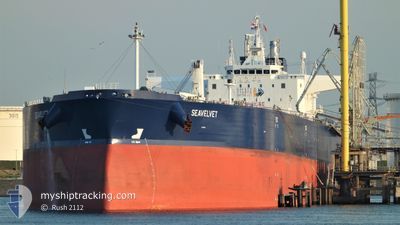
SEAVELVET
Tanker
Current Trip
| Time Travelled | --- |
|---|---|
| Remaining Time | --- |
| Distance Travelled | --- |
| Remaining Distance | --- |
| AVG Speed | --- |
| MAX Speed | --- |
| AVG Wind | --- |
| MAX Wind | --- |
| MIN Temp | --- |
| MAX Temp | --- |
| Tirant d eau | 13.8 m |
| Position reçue | 1 m depuis |
Current Position
| Longitude | 13.68634° |
|---|---|
| Latitude | 45.62532° |
| Etat | At anchor |
| Vitesse | 0.1 Noeuds |
| Parcours | 89° |
| Zone | Adriatic Sea |
| Station | T-AIS |
| Position reçue | 1 m depuis |
Info
Information
The current position of SEAVELVET is in Adriatic Sea with coordinates 45.62532° / 13.68634° as reported on 2024-04-25 03:44 by AIS to our vessel tracker app. The vessel's current speed is 0.1 Noeuds
The vessel SEAVELVET (IMO: 9843211, MMSI: 215514000) is a Tanker It's sailing under the flag of [MT] Malta.
In this page you can find informations about the vessels current position, last detected port calls, and current voyage information. If the vessels is not in coverage by AIS you will find the latest position.
The current position of SEAVELVET is detected by our AIS receivers and we are not responsible for the reliability of the data. The last position was recorded while the vessel was in Coverage by the Ais receivers of our vessel tracking app.
The current draught of SEAVELVET as reported by AIS is 13.8 meters
Weather
| Temperature | 5.8°C / 42.44°F |
|---|---|
| Wind Speed | 6 knots |
| Direction | 82° E |
| Pressure | 1007.9 hPa |
| Humidity | 89.9 % |
| Cloud Coverage | 100 % |
Featured Company
Last Port Calls
| Port | Arrival | Departure | Time In Port |
|---|---|---|---|
| 2024-04-16 14:21 | |||
| 2024-04-15 14:17 | 2024-04-15 19:07 | 4 h | |
| 2024-04-06 08:29 | 2024-04-08 09:24 | 2 d | |
| 2024-03-28 20:37 | 2024-03-29 15:07 | 18 h | |
| 2024-03-20 08:00 | 2024-03-21 16:30 | 1 d | |
| 2024-02-19 01:07 | 2024-02-20 06:27 | 1 d | |
| 2024-02-10 20:50 | 2024-02-11 16:42 | 19 h |
Most Visited Ports (Last year)
| Port | Arrivals | |
|---|---|---|
| 3 | ||
| 3 | ||
| 2 | ||
| 2 | ||
| 2 | ||
| 1 |
Last Trips
| Origin | Departure | Destination | Arrival | Distance | |
|---|---|---|---|---|---|
| 2024-04-15 22:07 | 2024-04-16 17:21 | 26.78 nm | |||
| 2024-04-08 12:24 | 2024-04-15 17:17 | 490.86 nm | |||
| 2024-03-29 18:07 | 2024-04-06 11:29 | 1124.10 nm | |||
| 2024-03-21 17:30 | 2024-03-28 23:37 | 1210.78 nm | |||
| 2024-02-20 07:27 | 2024-03-20 09:00 | 3344.97 nm | |||
| 2024-02-11 19:42 | 2024-02-19 02:07 | 1465.02 nm | |||
| 2024-01-28 18:36 | 2024-02-10 23:50 | 1994.00 nm |
Events
| Heure | Evenement | Détails | Position/ Destination | Info |
|---|---|---|---|---|
| 2024-04-25 01:09 | Arret | 3.46 nm, West of TRIESTE |
45.62512 / 13.68720
RUNVS>>ITTRS
|
Vitesse: 0.3 kn Parcours: 94° |
| 2024-04-25 01:09 | Etat Changé | At anchor Under way using engine |
45.62505 / 13.68719
RUNVS>>ITTRS
|
Vitesse: 0.4 kn Parcours: 91° |
| 2024-04-25 00:47 | Detecté en mer | Italian part of the Adriatic Sea |
45.61960 / 13.66820
Adriatic Sea
RUNVS>>ITTRS
|
Vitesse: 3.3 kn Parcours: 70.3° |
| 2024-04-24 23:29 | Changement de zone | Slovenian part of the Adriatic Sea Croatian part of the Adriatic Sea |
45.56142 / 13.49683
Adriatic Sea
RUNVS>>ITTRS
|
Vitesse: 8.6 kn Parcours: 62.1° |
| 2024-04-24 21:47 | Changement de zone | Croatian part of the Adriatic Sea Italian part of the Adriatic Sea |
45.43827 / 13.19754
Adriatic Sea
RUNVS>>ITTRS
|
Vitesse: 8.4 kn Parcours: 56.2° |
| 2024-04-24 21:32 | Changement de zone | Italian part of the Adriatic Sea Croatian part of the Adriatic Sea |
45.41016 / 13.16779
Adriatic Sea
RUNVS>>ITTRS
|
Vitesse: 8.7 kn Parcours: 12.9° |
| 2024-04-24 17:14 | Etat Changé | Under way using engine Default |
44.74197 / 13.55306
RUNVS>>ITTRS
|
Vitesse: 12.4 kn Parcours: 328° |
| 2024-04-24 17:00 | Dans la zone couverte |
44.75033 / 13.54604
Adriatic Sea
RUNVS>>ITTRS
|
Vitesse: 12.4 kn Parcours: 328.1° |
|
| 2024-04-24 13:45 | Etat Changé | Default Under way using engine |
44.14606 / 14.09814
RUNVS>>ITTRS
|
Vitesse: 12.2 kn Parcours: 322.3° |
| 2024-04-24 13:28 | Hors de la zone couverte |
44.10109 / 14.14272
Adriatic Sea
RUNVS>>ITTRS
|
Vitesse: 12.2 kn Parcours: 322.3° |