
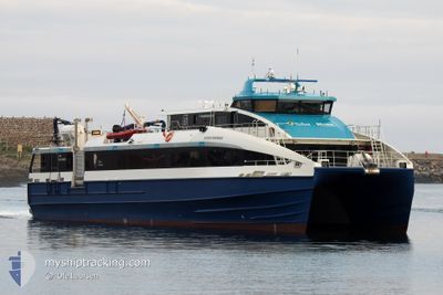
REGINE NORMANN
Passenger
Current Trip
| Time Travelled | 1 h, 34 mins |
|---|---|
| Remaining Time | 10 h, 1 mins |
| Distance Travelled | 32.70 nm |
| Remaining Distance | --- |
| AVG Speed | 27.7 Noeuds |
| MAX Speed | 33.9 Noeuds |
| AVG Wind | 9 knots |
| MAX Wind | 10 knots |
| MIN Temp | -1.5°C / 29.3°F |
| MAX Temp | 1.1°C / 33.98°F |
| Tirant d eau | 1.2 m |
| Position reçue | Maintenant |
Current Position
| Longitude | 15.07947° |
|---|---|
| Latitude | 67.91083° |
| Etat | Under way using engine |
| Vitesse | 33 Noeuds |
| Parcours | 276° |
| Zone | Norwegian Sea |
| Station | T-AIS |
| Position reçue | Maintenant |
Info
Information
The current position of REGINE NORMANN is in Norwegian Sea with coordinates 67.91083° / 15.07947° as reported on 2024-04-19 05:38 by AIS to our vessel tracker app. The vessel's current speed is 33 Noeuds and is heading at the port of ORNES. The estimated time of arrival as calculated by MyShipTracking vessel tracking app is 2024-04-19 15:40 LT
The vessel REGINE NORMANN (IMO: 9845623, MMSI: 257058290) is a Passenger It's sailing under the flag of [NO] Norway.
In this page you can find informations about the vessels current position, last detected port calls, and current voyage information. If the vessels is not in coverage by AIS you will find the latest position.
The current position of REGINE NORMANN is detected by our AIS receivers and we are not responsible for the reliability of the data. The last position was recorded while the vessel was in Coverage by the Ais receivers of our vessel tracking app.
The current draught of REGINE NORMANN as reported by AIS is 1.2 meters
Weather
| Temperature | 0.2°C / 32.36°F |
|---|---|
| Wind Speed | 7 knots |
| Direction | 99° E |
| Pressure | 1011.9 hPa |
| Humidity | 63.7 % |
| Cloud Coverage | 17 % |
Featured Company
Last Port Calls
| Port | Arrival | Departure | Time In Port |
|---|---|---|---|
| 2024-04-18 19:34 | 2024-04-19 04:05 | 8 h | |
| 2024-04-18 09:20 | 2024-04-18 16:06 | 6 h | |
| 2024-04-18 07:49 | 2024-04-18 07:54 | 4 m | |
| 2024-04-18 06:23 | 2024-04-18 06:27 | 4 m | |
| 2024-04-18 04:56 | 2024-04-18 05:00 | 4 m | |
| 2024-04-17 19:17 | 2024-04-18 04:28 | 9 h | |
| 2024-04-17 18:45 | 2024-04-17 18:49 | 4 m | |
| 2024-04-17 17:20 | 2024-04-17 17:24 | 4 m | |
| 2024-04-17 15:48 | 2024-04-17 15:55 | 6 m | |
| 2024-04-17 07:21 | 2024-04-17 14:18 | 6 h |
Last Trips
| Origin | Departure | Destination | Arrival | Distance | |
|---|---|---|---|---|---|
| 2024-04-18 18:06 | 2024-04-18 21:34 | 82.28 nm | |||
| 2024-04-18 09:54 | 2024-04-18 11:20 | 39.06 nm | |||
| 2024-04-18 08:27 | 2024-04-18 09:49 | 31.81 nm | |||
| 2024-04-18 07:00 | 2024-04-18 08:23 | 31.66 nm | |||
| 2024-04-18 06:28 | 2024-04-18 06:56 | 14.07 nm | |||
| 2024-04-17 20:49 | 2024-04-17 21:17 | 13.61 nm | |||
| 2024-04-17 19:24 | 2024-04-17 20:45 | 31.35 nm | |||
| 2024-04-17 17:55 | 2024-04-17 19:20 | 31.70 nm | |||
| 2024-04-17 16:18 | 2024-04-17 17:48 | 39.42 nm | |||
| 2024-04-17 06:03 | 2024-04-17 09:21 | 81.86 nm |
Events
| Heure | Evenement | Détails | Position/ Destination | Info |
|---|---|---|---|---|
| 2024-04-19 05:32 | Démarrage |
67.90141 / 15.19671
SSJ - BOO - SVJ
|
Vitesse: 24 kn Parcours: 60.2° |
|
| 2024-04-19 05:28 | Arret |
67.89994 / 15.18921
SSJ - BOO - SVJ
|
Vitesse: Parcours: 260° |
|
| 2024-04-19 05:10 | Démarrage | 16.74 nm, West of DRAG |
68.01125 / 15.34276
SSJ - BOO - SVJ
|
Vitesse: 19.9 kn Parcours: 176.2° |
| 2024-04-19 05:06 | Arret | 16.83 nm, West of DRAG |
68.01530 / 15.33741
SSJ - BOO - SVJ
|
Vitesse: 0.1 kn Parcours: 70° |
| 2024-04-19 04:25 | Démarrage | 4.84 nm, South East of KABELVAAG |
68.16256 / 14.65891
SSJ - BOO - SVJ
|
Vitesse: 17.5 kn Parcours: 203.6° |
| 2024-04-19 04:16 | Arret | 4.72 nm, South East of SVOLVAER |
68.16679 / 14.66230
SSJ - BOO - SVJ
|
Vitesse: 0.3 kn Parcours: 31° |
| 2024-04-19 04:05 | PORT DE DEPART |
|
68.21552 / 14.57085
SSJ - BOO - SVJ
|
Vitesse: 14.5 kn Parcours: 196° |
| 2024-04-19 04:03 | Démarrage |
68.22455 / 14.56076
[NO] SVOLVAER
|
Vitesse: 14.5 kn Parcours: 196° |
|
| 2024-04-19 03:34 | Etat Changé | Under way using engine Moored |
68.23146 / 14.56678
[NO] SVOLVAER
|
Vitesse: Parcours: 140° |
| 2024-04-18 19:41 | Etat Changé | Moored Under way using engine |
68.23145 / 14.56684
[NO] SVOLVAER
|
Vitesse: Parcours: 140° |