
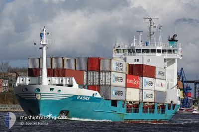
RAGNA
Container Ship
Current Trip
| Time Travelled | 2 days |
|---|---|
| Remaining Time | 7 h, 15 mins |
| Distance Travelled | 707.47 nm |
| Remaining Distance | 101.51 nm |
| AVG Speed | 9.7 Noeuds |
| MAX Speed | 15.7 Noeuds |
| AVG Wind | 6.8 knots |
| MAX Wind | 18.7 knots |
| MIN Temp | 1.2°C / 34.16°F |
| MAX Temp | 9.7°C / 49.46°F |
| Tirant d eau | 4.7 m |
| Position reçue | 38 m depuis |
Current Position
| Longitude | 16.64898° |
|---|---|
| Latitude | 54.78081° |
| Etat | Under way using engine |
| Vitesse | 12.2 Noeuds |
| Parcours | 78° |
| Zone | Baltic Sea |
| Station | T-AIS |
| Position reçue | 38 m depuis |
Info
Information
The current position of RAGNA is in Baltic Sea with coordinates 54.78081° / 16.64898° as reported on 2024-04-19 04:44 by AIS to our vessel tracker app. The vessel's current speed is 12.2 Noeuds and is heading at the port of GDYNIA. The estimated time of arrival as calculated by MyShipTracking vessel tracking app is 2024-04-19 12:37 LT
The vessel RAGNA (IMO: 9173329, MMSI: 211265530) is a Container Ship that was built in 1998 ( 26 Age ). It's sailing under the flag of [DE] Germany.
In this page you can find informations about the vessels current position, last detected port calls, and current voyage information. If the vessels is not in coverage by AIS you will find the latest position.
The current position of RAGNA is detected by our AIS receivers and we are not responsible for the reliability of the data. The last position was recorded while the vessel was in Coverage by the Ais receivers of our vessel tracking app.
The current draught of RAGNA as reported by AIS is 4.7 meters
Weather
| Temperature | 5.4°C / 41.72°F |
|---|---|
| Wind Speed | 7 knots |
| Direction | 225° SW |
| Pressure | 1006.3 hPa |
| Humidity | 84.7 % |
| Cloud Coverage | 100 % |
Featured Company
Last Port Calls
| Port | Arrival | Departure | Time In Port |
|---|---|---|---|
| 2024-04-16 07:38 | 2024-04-16 17:03 | 9 h | |
| 2024-04-14 10:03 | 2024-04-14 11:49 | 1 h | |
| 2024-04-12 11:43 | 2024-04-13 09:07 | 21 h | |
| 2024-04-05 09:06 | 2024-04-05 17:33 | 8 h | |
| 2024-04-01 18:25 | 2024-04-02 02:13 | 7 h | |
| 2024-03-29 18:25 | 2024-03-30 07:20 | 12 h | |
| 2024-03-26 14:51 | 2024-03-26 22:02 | 7 h | |
| 2024-03-22 18:40 | 2024-03-23 07:16 | 12 h | |
| 2024-03-19 13:38 | 2024-03-19 22:22 | 8 h | |
| 2024-03-15 19:40 | 2024-03-16 08:45 | 13 h |
Last Trips
| Origin | Departure | Destination | Arrival | Distance | |
|---|---|---|---|---|---|
| 2024-04-14 13:49 | 2024-04-16 08:38 | 429.64 nm | |||
| 2024-04-13 11:07 | 2024-04-14 12:03 | 343.00 nm | |||
| 2024-04-05 19:33 | 2024-04-12 13:43 | 10.32 nm | |||
| 2024-04-02 03:13 | 2024-04-05 11:06 | 868.10 nm | |||
| 2024-03-30 08:20 | 2024-04-01 19:25 | 870.08 nm | |||
| 2024-03-26 22:02 | 2024-03-29 19:25 | 907.53 nm | |||
| 2024-03-23 08:16 | 2024-03-26 14:51 | 886.75 nm | |||
| 2024-03-19 22:22 | 2024-03-22 19:40 | 869.77 nm | |||
| 2024-03-16 09:45 | 2024-03-19 13:38 | 885.34 nm | |||
| 2024-03-13 05:33 | 2024-03-15 20:40 | 791.90 nm |
Events
| Heure | Evenement | Détails | Position/ Destination | Info |
|---|---|---|---|---|
| 2024-04-18 23:50 | Detecté en mer | Polish part of the Baltic Sea |
54.62848 / 14.85301
Baltic Sea
PLGDY VIA NOK
|
Vitesse: 13.1 kn Parcours: 85° |
| 2024-04-18 22:56 | Changement de zone | Danish part of the Kattegat German part of the Baltic Sea |
54.60555 / 14.51999
Kattegat
PLGDY VIA NOK
|
Vitesse: 12.9 kn Parcours: 84° |
| 2024-04-18 15:59 | Detecté en mer | German part of the Baltic Sea |
54.40727 / 12.11025
Baltic Sea
PLGDY VIA NOK
|
Vitesse: 12.5 kn Parcours: 91° |
| 2024-04-18 14:02 | Detecté en mer | Danish part of the Baltic Sea |
54.49605 / 11.45168
Baltic Sea
PLGDY VIA NOK
|
Vitesse: 12.6 kn Parcours: 116° |
| 2024-04-18 12:05 | Changement de zone | German part of the Baltic Sea Danish part of the Baltic Sea |
54.55040 / 10.75357
Baltic Sea
PLGDY VIA NOK
|
Vitesse: 13.5 kn Parcours: 85° |
| 2024-04-18 11:50 | Changement de zone | Danish part of the Baltic Sea German part of the Baltic Sea |
54.54653 / 10.65939
Baltic Sea
PLGDY VIA NOK
|
Vitesse: 12.9 kn Parcours: 89° |
| 2024-04-18 10:41 | Changement de zone | German part of the Baltic Sea German part of the North Sea |
54.46176 / 10.27332
Baltic Sea
PLGDY VIA NOK
|
Vitesse: 12.8 kn Parcours: 38° |
| 2024-04-18 09:54 | Démarrage | 1.31 nm, South West of STICKENHΟRN SPORT |
54.36469 / 10.14708
PLGDY VIA NOK
|
Vitesse: 3.1 kn Parcours: 97° |
| 2024-04-18 09:13 | Arret | 1.41 nm, South West of STICKENHΟRN SPORT |
54.36589 / 10.13997
PLGDY VIA NOK
|
Vitesse: 0.2 kn Parcours: 103° |
| 2024-04-18 04:27 | Démarrage | 2.48 nm, North East of FISCHERHUTTE |
54.17085 / 9.43747
PLGDY VIA NOK
|
Vitesse: 3.1 kn Parcours: 61° |