
PLAN A
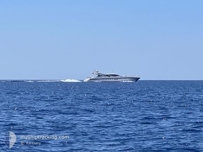
Yacht
Current Trip
| Trip Time | 2 h, 6 mins |
|---|---|
| Trip Distance | 12.51 nm |
| AVG Speed | 15.3 Noeuds |
| MAX Speed | 15.3 Noeuds |
| Tirant d eau | 1.9 m |
| AVG Wind | 3.7 knots |
| MAX Wind | 5.8 knots |
| MIN Temp | 11.1°C / 51.98°F |
| MAX Temp | 11.3°C / 52.34°F |
| Position reçue | 14 h, 14 m depuis |
Current Position
| Longitude | 7.12919° |
|---|---|
| Latitude | 43.58494° |
| Etat | Under way using engine |
| Vitesse | |
| Parcours | 246° |
| Zone | Mediterranean Sea - Western Basin |
| Station | T-AIS |
| Position reçue | 14 h, 14 m depuis |
Info
Information
The current position of PLAN A is in Mediterranean Sea - Western Basin with coordinates 43.58494° / 7.12919° as reported on 2024-04-24 11:55 by AIS to our vessel tracker app. The vessel's current speed is 0 Noeuds and is currently inside the port of ANTIBES.
The vessel PLAN A (IMO: 8742525, MMSI: 256002231) is a Yacht that was built in 2007 ( 17 Age ). It's sailing under the flag of [MT] Malta.
In this page you can find informations about the vessels current position, last detected port calls, and current voyage information. If the vessels is not in coverage by AIS you will find the latest position.
The current position of PLAN A is detected by our AIS receivers and we are not responsible for the reliability of the data. The last position was recorded while the vessel was in Coverage by the Ais receivers of our vessel tracking app.
The current draught of PLAN A as reported by AIS is 1.9 meters
Weather
| Temperature | 11.7°C / 53.06°F |
|---|---|
| Wind Speed | 7 knots |
| Direction | 201° SSW |
| Pressure | 1007.6 hPa |
| Humidity | 66.4 % |
| Cloud Coverage | 3 % |
Featured Company
Events
| Heure | Evenement | Détails | Position/ Destination | Info |
|---|---|---|---|---|
| 2024-04-24 11:55 | Hors de la zone couverte |
43.58494 / 7.12919
Mediterranean Sea - Western Basin
[FR] ANTIBES
|
Vitesse: Parcours: 301.3° |
|
| 2024-04-24 10:10 | Arret |
43.58664 / 7.12806
[FR] ANTIBES
|
Vitesse: 0.1 kn Parcours: 221° |
|
| 2024-04-24 10:01 | Port d'arrivée |
|
43.59077 / 7.13107
[FR] ANTIBES
|
Vitesse: 4.9 kn Parcours: 207° |
| 2024-04-24 09:53 | Démarrage | 0.63 nm, South East of ANTIBES |
43.58211 / 7.14068
CANNES
|
Vitesse: 4.1 kn Parcours: 9° |
| 2024-04-24 08:44 | Arret | 0.69 nm, South East of ANTIBES |
43.58019 / 7.14086
CANNES
|
Vitesse: 0.2 kn Parcours: 155° |
| 2024-04-24 07:55 | PORT DE DEPART |
|
43.59210 / 7.13235
CANNES
|
Vitesse: 5 kn Parcours: 81° |
| 2024-04-24 07:50 | Démarrage |
43.58657 / 7.12800
[FR] ANTIBES
|
Vitesse: 3.8 kn Parcours: 44° |
|
| 2024-04-24 05:12 | Dans la zone couverte |
43.58489 / 7.12924
Mediterranean Sea - Western Basin
[FR] ANTIBES
|
Vitesse: Parcours: 277.3° |