
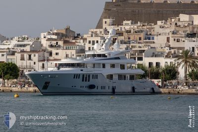
ODESSA II
Yacht
Current Trip
| Time Travelled | 14 days |
|---|---|
| Remaining Time | --- |
| Distance Travelled | 1668.97 nm |
| Remaining Distance | --- |
| AVG Speed | 14.3 Noeuds |
| MAX Speed | 17.3 Noeuds |
| AVG Wind | 12.1 knots |
| MAX Wind | 26 knots |
| MIN Temp | 10.7°C / 51.26°F |
| MAX Temp | 19.5°C / 67.1°F |
| Tirant d eau | 3.6 m |
| Position reçue | 6 d depuis |
Current Position
| Longitude | 13.00097° |
|---|---|
| Latitude | 45.46950° |
| Etat | Under way using engine |
| Vitesse | 13.4 Noeuds |
| Parcours | 246.9° |
| Zone | Adriatic Sea |
| Station | T-AIS |
| Position reçue | 6 d depuis |
Info
Information
The current position of ODESSA II is in Adriatic Sea with coordinates 45.46950° / 13.00097° as reported on 2024-04-13 09:26 by AIS to our vessel tracker app. The vessel's current speed is 13.4 Noeuds
The vessel ODESSA II (IMO: 9645671, MMSI: 538070951) is a Yacht that was built in 2013 ( 11 Age ). It's sailing under the flag of [MH] Marshall Is.
In this page you can find informations about the vessels current position, last detected port calls, and current voyage information. If the vessels is not in coverage by AIS you will find the latest position.
The current position of ODESSA II is detected by our AIS receivers and we are not responsible for the reliability of the data. The last position was recorded while the vessel was in Coverage by the Ais receivers of our vessel tracking app.
The current draught of ODESSA II as reported by AIS is 3.6 meters
Weather
| Temperature | 16.1°C / 60.98°F |
|---|---|
| Wind Speed | 5 knots |
| Direction | 24° NNE |
| Pressure | 1027.3 hPa |
| Humidity | 77.2 % |
| Cloud Coverage | 91 % |
Featured Company
Last Port Calls
| Port | Arrival | Departure | Time In Port |
|---|---|---|---|
| 2024-04-05 05:47 | 2024-04-05 15:55 | 10 h | |
| 2024-03-21 17:07 | 2024-03-25 14:54 | 3 d | |
| 2024-03-11 10:55 | 2024-03-13 11:53 | 2 d | |
| 2024-02-29 13:46 | 2024-03-11 03:10 | 10 d | |
| 2024-02-15 21:57 | 2024-02-29 12:17 | 13 d | |
| 2024-02-05 16:27 | 2024-02-09 11:48 | 3 d | |
| 2024-02-04 22:13 |
Last Trips
| Origin | Departure | Destination | Arrival | Distance | |
|---|---|---|---|---|---|
| 2024-03-25 10:54 | 2024-04-05 07:47 | 3197.91 nm | |||
| 2024-03-10 23:10 | 2024-03-11 06:55 | 100.65 nm | |||
| 2024-02-29 08:17 | 2024-02-29 09:46 | 14.72 nm | |||
| 2024-02-09 07:48 | 2024-02-15 17:57 | 206.48 nm | |||
| 2024-02-04 18:13 | 2024-02-05 12:27 | 97.18 nm |
Events
| Heure | Evenement | Détails | Position/ Destination | Info |
|---|---|---|---|---|
| 2024-04-13 09:26 | Hors de la zone couverte |
45.46950 / 13.00097
Adriatic Sea
ITVCE
|
Vitesse: 13.4 kn Parcours: 246.9° |
|
| 2024-04-13 07:23 | Dans la zone couverte |
45.65688 / 13.67919
Adriatic Sea
ITVCE
|
Vitesse: 13.2 kn Parcours: 276.6° |
|
| 2024-04-13 07:19 | Changement de destination | ITVCE TRIESTE |
45.65498 / 13.75524
ITVCE
|
Vitesse: 4.8 kn Parcours: 123° |
| 2024-04-13 07:19 | Changement d'ETA | 2024/04/13 16:30 2025/03/25 12:30 |
45.65498 / 13.75524
ITVCE
|
Vitesse: 4.8 kn Parcours: 123° |
| 2024-04-11 12:06 | Hors de la zone couverte |
45.65665 / 13.75155
Adriatic Sea
|
Vitesse: 4.8 kn Parcours: 121° |
|
| 2024-04-11 11:57 | Etat Changé | Under way using engine At anchor |
45.66255 / 13.73837
TRIESTE
|
Vitesse: 0.5 kn Parcours: 38° |
| 2024-04-11 11:57 | Démarrage | 2.43 nm, North West of TRIESTE |
45.66255 / 13.73837
TRIESTE
|
Vitesse: 4.7 kn Parcours: 124° |
| 2024-04-11 10:23 | Arret | 3.06 nm, North West of TRIESTE |
45.67019 / 13.72778
TRIESTE
|
Vitesse: 0.3 kn Parcours: 78° |
| 2024-04-11 09:51 | Dans la zone couverte |
45.67067 / 13.72752
Adriatic Sea
|
Vitesse: 1.1 kn Parcours: 185.5° |
|
| 2024-04-11 08:18 | Hors de la zone couverte |
45.67073 / 13.72752
Adriatic Sea
|
Vitesse: 0.9 kn Parcours: 187.7° |