
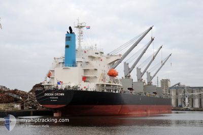
OCEAN CROWN
Bulk Carrier
Current Trip
| Time Travelled | 38 days |
|---|---|
| Remaining Time | 2 days |
| Distance Travelled | 7781.18 nm |
| Remaining Distance | 780.75 nm |
| AVG Speed | 10.5 Noeuds |
| MAX Speed | 14.1 Noeuds |
| AVG Wind | 11.6 knots |
| MAX Wind | 30 knots |
| MIN Temp | 15.6°C / 60.08°F |
| MAX Temp | 35.8°C / 96.44°F |
| Tirant d eau | 9.4 m |
| Position reçue | 3 d depuis |
Current Position
| Longitude | 1.43185° |
|---|---|
| Latitude | -14.17288° |
| Etat | Under way using engine |
| Vitesse | 11.1 Noeuds |
| Parcours | 317.9° |
| Zone | South Atlantic Ocean |
| Station | T-AIS |
| Position reçue | 3 d depuis |
Info
Information
The current position of OCEAN CROWN is in South Atlantic Ocean with coordinates -14.17288° / 1.43185° as reported on 2024-04-22 01:06 by AIS to our vessel tracker app. The vessel's current speed is 11.1 Noeuds and is heading at the port of CONAKRY. The estimated time of arrival as calculated by MyShipTracking vessel tracking app is 2024-04-28 10:48 LT
The vessel OCEAN CROWN (IMO: 9317107, MMSI: 212909000) is a Bulk Carrier that was built in 2005 ( 19 Age ). It's sailing under the flag of [CY] Cyprus.
In this page you can find informations about the vessels current position, last detected port calls, and current voyage information. If the vessels is not in coverage by AIS you will find the latest position.
The current position of OCEAN CROWN is detected by our AIS receivers and we are not responsible for the reliability of the data. The last position was recorded while the vessel was in Coverage by the Ais receivers of our vessel tracking app.
The current draught of OCEAN CROWN as reported by AIS is 9.4 meters
Weather
| Temperature | 28.7°C / 83.66°F |
|---|---|
| Wind Speed | 8 knots |
| Direction | 135° SE |
| Pressure | 1010.7 hPa |
| Humidity | 74.4 % |
| Cloud Coverage | 100 % |
Featured Company
Last Port Calls
| Port | Arrival | Departure | Time In Port |
|---|---|---|---|
| 2024-03-13 07:45 | 2024-03-18 00:46 | 4 d | |
| 2024-03-12 03:24 | 2024-03-12 03:30 | 5 m | |
| 2024-03-12 00:06 | 2024-03-12 03:06 | 2 h | |
| 2024-03-10 23:33 | 2024-03-11 03:30 | 3 h | |
| 2024-03-01 09:42 | 2024-03-09 05:24 | 7 d | |
| 2024-02-10 05:30 | 2024-02-10 15:11 | 9 h | |
| 2024-02-03 10:29 |
Last Trips
| Origin | Departure | Destination | Arrival | Distance | |
|---|---|---|---|---|---|
| 2024-03-12 09:00 | 2024-03-13 13:15 | 7.56 nm | |||
| 2024-03-12 08:36 | 2024-03-12 08:54 | 0.11 nm | |||
| 2024-03-11 09:00 | 2024-03-12 05:36 | 3.96 nm | |||
| 2024-03-09 10:54 | 2024-03-11 05:03 | 161.64 nm | |||
| 2024-02-03 11:29 | 2024-03-01 15:12 | 5679.29 nm | |||
| 2024-02-03 11:29 | 2024-02-10 07:30 | 1306.65 nm |
Events
| Heure | Evenement | Détails | Position/ Destination | Info |
|---|---|---|---|---|
| 2024-04-22 01:07 | Etat Changé | Default Under way using engine |
-14.16850 / 1.42885
CONAKRY-GN CKY
|
Vitesse: 11.1 kn Parcours: 317.9° |
| 2024-04-22 01:06 | Etat Changé | Under way using engine Default |
-14.17288 / 1.43185
CONAKRY-GN CKY
|
Vitesse: 11 kn Parcours: 327° |
| 2024-04-22 01:06 | Hors de la zone couverte |
-14.17288 / 1.43185
South Atlantic Ocean
CONAKRY-GN CKY
|
Vitesse: 11.1 kn Parcours: 317.9° |
|
| 2024-04-22 00:55 | Dans la zone couverte |
-14.17288 / 1.43185
South Atlantic Ocean
CONAKRY-GN CKY
|
Vitesse: 11.1 kn Parcours: 317.9° |
|
| 2024-04-21 22:06 | Etat Changé | Default Under way using engine |
-14.62877 / 1.77535
CONAKRY-GN CKY
|
Vitesse: 11.5 kn Parcours: 326.9° |
| 2024-04-21 22:02 | Hors de la zone couverte |
-14.63822 / 1.78232
South Atlantic Ocean
CONAKRY-GN CKY
|
Vitesse: 11.5 kn Parcours: 326.9° |
|
| 2024-04-21 22:01 | Etat Changé | Under way using engine Default |
-14.64218 / 1.78575
CONAKRY-GN CKY
|
Vitesse: 11.5 kn Parcours: 316° |
| 2024-04-21 21:51 | Dans la zone couverte |
-14.64218 / 1.78575
South Atlantic Ocean
CONAKRY-GN CKY
|
Vitesse: 11.4 kn Parcours: 323.3° |
|
| 2024-04-21 20:17 | Etat Changé | Default Under way using engine |
-14.89818 / 1.98500
CONAKRY-GN CKY
|
Vitesse: 11 kn Parcours: 317.8° |
| 2024-04-21 20:14 | Hors de la zone couverte |
-14.90538 / 1.99093
South Atlantic Ocean
CONAKRY-GN CKY
|
Vitesse: 11 kn Parcours: 317.8° |