
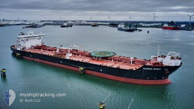
NANSEN SPIRIT
Oil Products Tanker
Current Trip
| Time Travelled | 8 days |
|---|---|
| Remaining Time | 21 h, 19 mins |
| Distance Travelled | 1186.09 nm |
| Remaining Distance | 268.07 nm |
| AVG Speed | 11.3 Noeuds |
| MAX Speed | 14 Noeuds |
| AVG Wind | 18.9 knots |
| MAX Wind | 38.9 knots |
| MIN Temp | 3.6°C / 38.48°F |
| MAX Temp | 12.6°C / 54.68°F |
| Tirant d eau | 12.2 m |
| Position reçue | 1 m depuis |
Current Position
| Longitude | 8.30166° |
|---|---|
| Latitude | 57.70729° |
| Etat | Under way using engine |
| Vitesse | 12.6 Noeuds |
| Parcours | 85.3° |
| Zone | Skaggerak |
| Station | T-AIS |
| Position reçue | 1 m depuis |
Info
Information
The current position of NANSEN SPIRIT is in Skaggerak with coordinates 57.70729° / 8.30166° as reported on 2024-04-19 18:46 by AIS to our vessel tracker app. The vessel's current speed is 12.6 Noeuds and is heading at the port of FREDERICIA. The estimated time of arrival as calculated by MyShipTracking vessel tracking app is 2024-04-20 16:06 LT
The vessel NANSEN SPIRIT (IMO: 9438860, MMSI: 311027500) is a Oil Products Tanker that was built in 2010 ( 14 Age ). It's sailing under the flag of [BS] Bahamas.
In this page you can find informations about the vessels current position, last detected port calls, and current voyage information. If the vessels is not in coverage by AIS you will find the latest position.
The current position of NANSEN SPIRIT is detected by our AIS receivers and we are not responsible for the reliability of the data. The last position was recorded while the vessel was in Coverage by the Ais receivers of our vessel tracking app.
The current draught of NANSEN SPIRIT as reported by AIS is 12.2 meters
Weather
| Temperature | 5°C / 41°F |
|---|---|
| Wind Speed | 12 knots |
| Direction | 51° NE |
| Pressure | 1010.4 hPa |
| Humidity | 63.2 % |
| Cloud Coverage | 34 % |
Featured Company
Most Visited Ports (Last year)
| Port | Arrivals | |
|---|---|---|
| 7 | ||
| 5 | ||
| 2 | ||
| 2 | ||
| 1 | ||
| 1 |
Last Trips
| Origin | Departure | Destination | Arrival | Distance | |
|---|---|---|---|---|---|
| 2024-04-10 09:02 | 2024-04-10 09:20 | 1.77 nm | |||
| 2024-03-26 01:39 | 2024-04-09 07:29 | 342.36 nm | |||
| 2024-02-26 20:49 | 2024-03-24 23:26 | 1417.83 nm | |||
| 2024-02-03 19:19 | 2024-02-25 19:37 | 1553.69 nm |
Events
| Heure | Evenement | Détails | Position/ Destination | Info |
|---|---|---|---|---|
| 2024-04-19 16:56 | Detecté en mer | Norwegian part of the Skaggerak |
57.67860 / 7.58617
Skaggerak
DKFRC
|
Vitesse: 12.5 kn Parcours: 92° |
| 2024-04-19 06:09 | Tirant d'eau modifié | 12.2 9.3 |
58.30442 / 3.69574
DKFRC
|
Vitesse: 11.9 kn Parcours: 112.1° |
| 2024-04-19 06:09 | Changement de destination | DKFRC SCHIEHALLION OF |
58.30442 / 3.69574
DKFRC
|
Vitesse: 11.9 kn Parcours: 112.1° |
| 2024-04-19 06:09 | Changement d'ETA | 2024/04/20 18:00 2024/04/16 11:00 |
58.30442 / 3.69574
DKFRC
|
Vitesse: 11.9 kn Parcours: 112.1° |
| 2024-04-19 05:58 | Detecté en mer | Norwegian part of the North Sea |
58.31497 / 3.64525
North Sea
|
Vitesse: 11.9 kn Parcours: 111.6° |
| 2024-04-19 05:56 | Dans la zone couverte |
58.31497 / 3.64525
North Sea
|
Vitesse: 11.9 kn Parcours: 111.6° |
|
| 2024-04-18 07:35 | Démarrage |
60.34833 / -4.03167
SCHIEHALLION OF
|
Vitesse: 9 kn Parcours: 140° |
|
| 2024-04-17 03:32 | Arret |
60.34333 / -4.06333
SCHIEHALLION OF
|
Vitesse: Parcours: -1° |
|
| 2024-04-16 16:56 | Démarrage |
60.28833 / -4.46833
SCHIEHALLION OF
|
Vitesse: 5 kn Parcours: 332° |
|
| 2024-04-16 15:47 | Arret |
60.26667 / -4.38833
SCHIEHALLION OF
|
Vitesse: Parcours: -1° |