
MSC ALICE II
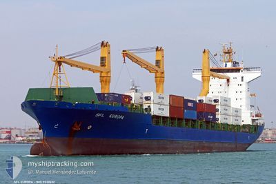
Container Ship
Current Trip
| Trip Time | 7 days |
|---|---|
| Trip Distance | 281.02 nm |
| AVG Speed | 9.8 Noeuds |
| MAX Speed | 15.5 Noeuds |
| Tirant d eau | 9.7 m |
| AVG Wind | 3.9 knots |
| MAX Wind | 10 knots |
| MIN Temp | 23.4°C / 74.12°F |
| MAX Temp | 36.3°C / 97.34°F |
| Position reçue | 2023-11-11 17:05 |
Current Position
| Longitude | 3.38723° |
|---|---|
| Latitude | 6.43614° |
| Etat | Moored |
| Vitesse | |
| Parcours | 291° |
| Zone | Gulf of Guinea |
| Station | T-AIS |
| Position reçue | 2023-11-11 17:05 |
Info
Information
The current position of MSC ALICE II is in Gulf of Guinea with coordinates 6.43614° / 3.38723° as reported on 2023-11-11 17:05 by AIS to our vessel tracker app. The vessel's current speed is 0 Noeuds and is currently inside the port of MATADI.
The vessel MSC ALICE II (IMO: 9232632, MMSI: 636018026) is a Container Ship that was built in 2003 ( 21 Age ). It's sailing under the flag of [LR] Liberia.
In this page you can find informations about the vessels current position, last detected port calls, and current voyage information. If the vessels is not in coverage by AIS you will find the latest position.
The current position of MSC ALICE II is detected by our AIS receivers and we are not responsible for the reliability of the data. The last position was recorded while the vessel was in Coverage by the Ais receivers of our vessel tracking app.
The current draught of MSC ALICE II as reported by AIS is 9.7 meters
Weather
| Temperature | 23.7°C / 74.66°F |
|---|---|
| Wind Speed | 1 knots |
| Direction | 141° SE |
| Pressure | 1010.1 hPa |
| Humidity | 92.9 % |
| Cloud Coverage | 100 % |
Featured Company
Last Port Calls
| Port | Arrival | Departure | Time In Port |
|---|---|---|---|
| 2024-04-23 15:37 | |||
| 2024-04-07 22:56 | 2024-04-16 06:02 | 8 d | |
| 2024-04-02 09:09 | |||
| 2024-03-11 00:00 | 2024-03-13 14:57 | 2 d | |
| 2024-02-23 15:41 | 2024-03-03 18:39 | 9 d | |
| 2024-02-07 07:53 | 2024-02-09 10:09 | 2 d | |
| 2024-02-04 13:10 |
Most Visited Ports (Last year)
| Port | Arrivals | |
|---|---|---|
| 9 | ||
| 7 | ||
| 5 | ||
| 5 | ||
| 3 | ||
| 3 |
Last Trips
| Origin | Departure | Destination | Arrival | Distance | |
|---|---|---|---|---|---|
| 2024-04-16 07:02 | 2024-04-23 16:37 | 281.02 nm | |||
| 2024-04-02 10:09 | 2024-04-07 23:56 | 372.75 nm | |||
| 2024-03-03 19:39 | 2024-03-11 01:00 | 114.41 nm | |||
| 2024-02-09 11:09 | 2024-02-23 16:41 | 246.66 nm | |||
| 2024-02-04 14:10 | 2024-02-07 08:53 | 350.26 nm |
Events
| Heure | Evenement | Détails | Position/ Destination | Info |
|---|---|---|---|---|
| 2024-04-23 15:37 | Port d'arrivée |
|
-5.82278 / 13.45008
[CD] MATADI
|
Vitesse: Parcours: -1° |
| 2024-04-23 15:33 | Arret | 0.42 nm, West of MATADI |
-5.82167 / 13.44833
BJCOO
|
Vitesse: Parcours: -1° |
| 2024-04-23 11:46 | Démarrage | 0.21 nm, South of BOMA |
-5.86266 / 13.04793
BJCOO
|
Vitesse: 6 kn Parcours: 85° |
| 2024-04-17 15:15 | Arret | 0.47 nm, South West of BOMA |
-5.86500 / 13.04333
BJCOO
|
Vitesse: Parcours: -1° |
| 2024-04-17 07:51 | Démarrage | 7.06 nm, North West of SOYO |
-6.04496 / 12.23394
BJCOO
|
Vitesse: 4 kn Parcours: 129° |
| 2024-04-17 07:21 | Arret | 6.51 nm, North West of SOYO |
-6.04013 / 12.24937
BJCOO
|
Vitesse: 0.1 kn Parcours: 105° |
| 2024-04-16 18:31 | Démarrage | 1.57 nm, North West of POINTE NOIRE |
-4.75780 / 11.82012
BJCOO
|
Vitesse: 5.1 kn Parcours: 243° |
| 2024-04-16 06:17 | Arret | 1.54 nm, North West of POINTE NOIRE |
-4.75602 / 11.82410
BJCOO
|
Vitesse: 0.3 kn Parcours: 93° |
| 2024-04-16 06:02 | PORT DE DEPART |
|
-4.76418 / 11.82666
BJCOO
|
Vitesse: 4.4 kn Parcours: 355° |
| 2024-04-16 05:50 | Démarrage |
-4.77802 / 11.83386
[CG] POINTE NOIRE
|
Vitesse: 4.4 kn Parcours: 355° |