
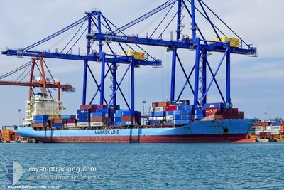
MAERSK NEWPORT
Container Ship
Current Trip
| Trip Time | --- |
|---|---|
| Trip Distance | --- |
| AVG Speed | --- |
| MAX Speed | --- |
| Tirant d eau | --- |
| AVG Wind | --- |
| MAX Wind | --- |
| MIN Temp | --- |
| MAX Temp | --- |
| Position reçue | 4 h, 42 m depuis |
Current Position
| Longitude | 32.35702° |
|---|---|
| Latitude | 31.21747° |
| Etat | Moored |
| Vitesse | |
| Parcours | 193° |
| Zone | Mediterranean Sea - Eastern Basin |
| Station | T-AIS |
| Position reçue | 4 h, 42 m depuis |
Info
Information
The current position of MAERSK NEWPORT is in Mediterranean Sea - Eastern Basin with coordinates 31.21747° / 32.35702° as reported on 2024-04-19 01:07 by AIS to our vessel tracker app. The vessel's current speed is 0 Noeuds and is currently inside the port of SUEZ CANAL.
The vessel MAERSK NEWPORT (IMO: 9356127, MMSI: 219223000) is a Container Ship that was built in 2008 ( 16 Age ). It's sailing under the flag of [DK] Denmark.
In this page you can find informations about the vessels current position, last detected port calls, and current voyage information. If the vessels is not in coverage by AIS you will find the latest position.
The current position of MAERSK NEWPORT is detected by our AIS receivers and we are not responsible for the reliability of the data. The last position was recorded while the vessel was in Coverage by the Ais receivers of our vessel tracking app.
The current draught of MAERSK NEWPORT as reported by AIS is 10.4 meters
Weather
| Temperature | 19°C / 66.2°F |
|---|---|
| Wind Speed | 5 knots |
| Direction | 334° NNW |
| Pressure | 1013.5 hPa |
| Humidity | 77.5 % |
| Cloud Coverage | --- |
Featured Company
Last Port Calls
| Port | Arrival | Departure | Time In Port |
|---|---|---|---|
| 2024-04-11 22:49 | 2024-04-13 18:37 | 1 d | |
| 2024-04-05 21:25 | 2024-04-06 21:30 | 1 d | |
| 2024-04-02 19:10 | 2024-04-03 12:01 | 16 h | |
| 2024-03-28 23:16 | 2024-03-30 15:20 | 1 d | |
| 2024-03-23 04:13 | 2024-03-24 06:52 | 1 d | |
| 2024-03-13 18:02 | 2024-03-15 10:37 | 1 d | |
| 2024-03-04 04:23 | 2024-03-05 04:16 | 23 h | |
| 2024-02-24 11:52 | 2024-02-26 03:25 | 1 d | |
| 2024-02-22 04:39 | 2024-02-22 16:42 | 12 h | |
| 2024-02-16 20:50 | 2024-02-17 20:54 | 1 d |
Last Trips
| Origin | Departure | Destination | Arrival | Distance | |
|---|---|---|---|---|---|
| 2024-04-03 15:01 | 2024-04-12 01:49 | 1891.54 nm | |||
| 2024-04-03 15:01 | 2024-04-05 23:25 | 818.77 nm | |||
| 2024-03-30 17:20 | 2024-04-02 22:10 | 271.42 nm | |||
| 2024-03-15 12:37 | 2024-03-29 01:16 | 2178.81 nm | |||
| 2024-03-15 12:37 | 2024-03-23 06:13 | 1108.37 nm | |||
| 2024-02-26 05:25 | 2024-03-13 20:02 | 2316.21 nm | |||
| 2024-02-26 05:25 | 2024-03-04 06:23 | 1112.96 nm | |||
| 2024-02-22 19:42 | 2024-02-24 13:52 | 260.16 nm | |||
| 2024-02-14 17:39 | 2024-02-22 07:39 | 1705.88 nm | |||
| 2024-02-14 17:39 | 2024-02-16 22:50 | 818.90 nm |
Events
| Heure | Evenement | Détails | Position/ Destination | Info |
|---|---|---|---|---|
| 2024-04-19 01:07 | Hors de la zone couverte |
31.21747 / 32.35702
Mediterranean Sea - Eastern Basin
[EG] SUEZ CANAL
|
Vitesse: Parcours: 106.5° |
|
| 2024-04-19 01:07 | Dans la zone couverte |
31.21747 / 32.35702
Mediterranean Sea - Eastern Basin
[EG] SUEZ CANAL
|
Vitesse: Parcours: 106.5° |
|
| 2024-04-18 01:45 | Etat Changé | Default Under way using engine |
35.07500 / 28.59667
ROCND>>EGPSD
|
Vitesse: 18.5 kn Parcours: 133.6° |
| 2024-04-18 01:22 | Hors de la zone couverte |
35.15505 / 28.49318
Mediterranean Sea - Eastern Basin
ROCND>>EGPSD
|
Vitesse: 18.5 kn Parcours: 133.6° |
|
| 2024-04-17 22:14 | Changement de zone | Greek part of the Mediterranean Sea - Eastern Basin Greek part of the Aegean Sea |
35.82532 / 27.65165
Mediterranean Sea - Eastern Basin
ROCND>>EGPSD
|
Vitesse: 18.1 kn Parcours: 134.3° |
| 2024-04-17 11:07 | Etat Changé | Under way using engine Default |
38.34950 / 25.73142
ROCND>>EGPSD
|
Vitesse: 16 kn Parcours: 172° |
| 2024-04-17 11:03 | Etat Changé | Default Under way using engine |
38.36666 / 25.72833
ROCND>>EGPSD
|
Vitesse: 15.5 kn Parcours: 171.4° |
| 2024-04-17 10:57 | Etat Changé | Under way using engine Default |
38.39410 / 25.72380
ROCND>>EGPSD
|
Vitesse: 15.8 kn Parcours: 176° |
| 2024-04-17 10:42 | Dans la zone couverte |
38.38982 / 25.72450
Aegean Sea
ROCND>>EGPSD
|
Vitesse: 15.5 kn Parcours: 172.6° |
|
| 2024-04-17 09:33 | Hors de la zone couverte |
38.76083 / 25.69027
Aegean Sea
ROCND>>EGPSD
|
Vitesse: 16.6 kn Parcours: 168.7° |