
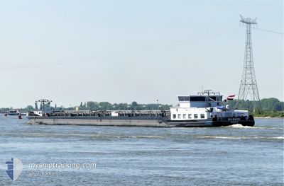
MA-BAKER
Tanker
Current Trip
| Time Travelled | 4 h, 24 mins |
|---|---|
| Remaining Time | 9 h, 59 mins |
| Distance Travelled | 38.16 nm |
| Remaining Distance | 106.14 nm |
| AVG Speed | 10.1 Noeuds |
| MAX Speed | 11.1 Noeuds |
| AVG Wind | 11.5 knots |
| MAX Wind | 12.2 knots |
| MIN Temp | 6.9°C / 44.42°F |
| MAX Temp | 9.6°C / 49.28°F |
| Tirant d eau | 1.5 m |
| Position reçue | 39 m depuis |
Current Position
| Longitude | 6.59089° |
|---|---|
| Latitude | 51.61226° |
| Etat | Under way using engine |
| Vitesse | 10.1 Noeuds |
| Parcours | 339.4° |
| Zone | North Sea |
| Station | T-AIS |
| Position reçue | 39 m depuis |
Info
Information
The current position of MA-BAKER is in North Sea with coordinates 51.61226° / 6.59089° as reported on 2024-04-19 10:42 by AIS to our vessel tracker app. The vessel's current speed is 10.1 Noeuds and is heading at the port of ROTTERDAM. The estimated time of arrival as calculated by MyShipTracking vessel tracking app is 2024-04-19 21:21 LT
The vessel MA-BAKER (MMSI: 244660412) is a Tanker It's sailing under the flag of [NL] Netherlands.
In this page you can find informations about the vessels current position, last detected port calls, and current voyage information. If the vessels is not in coverage by AIS you will find the latest position.
The current position of MA-BAKER is detected by our AIS receivers and we are not responsible for the reliability of the data. The last position was recorded while the vessel was in Coverage by the Ais receivers of our vessel tracking app.
The current draught of MA-BAKER as reported by AIS is 1.5 meters
Weather
| Temperature | 8.3°C / 46.94°F |
|---|---|
| Wind Speed | 13 knots |
| Direction | 306° NW |
| Pressure | 1007.1 hPa |
| Humidity | 90.6 % |
| Cloud Coverage | 100 % |
Featured Company
Last Port Calls
| Port | Arrival | Departure | Time In Port |
|---|---|---|---|
| 2024-04-18 15:39 | 2024-04-19 06:58 | 15 h | |
| 2024-04-13 12:00 | 2024-04-14 03:44 | 15 h | |
| 2024-04-11 20:48 | 2024-04-12 09:16 | 12 h | |
| 2024-04-10 22:47 | 2024-04-11 19:11 | 20 h | |
| 2024-04-08 03:40 | 2024-04-10 22:18 | 2 d | |
| 2024-04-07 12:05 | 2024-04-08 03:09 | 15 h | |
| 2024-04-06 12:49 | 2024-04-07 11:55 | 23 h | |
| 2024-04-06 05:05 | 2024-04-06 12:32 | 7 h | |
| 2024-04-04 11:20 | 2024-04-06 03:34 | 1 d | |
| 2024-04-03 21:49 | 2024-04-04 09:47 | 11 h |
Most Visited Ports (Last year)
| Port | Arrivals | |
|---|---|---|
| 39 | ||
| 29 | ||
| 28 | ||
| 26 | ||
| 22 | ||
| 21 |
Last Trips
| Origin | Departure | Destination | Arrival | Distance | |
|---|---|---|---|---|---|
| 2024-04-14 05:44 | 2024-04-18 17:39 | 302.86 nm | |||
| 2024-04-12 11:16 | 2024-04-13 14:00 | 65.28 nm | |||
| 2024-04-11 21:11 | 2024-04-11 22:48 | 13.13 nm | |||
| 2024-04-11 00:18 | 2024-04-11 00:47 | 3.80 nm | |||
| 2024-04-08 05:09 | 2024-04-08 05:40 | 3.00 nm | |||
| 2024-04-07 13:55 | 2024-04-07 14:05 | 0.58 nm | |||
| 2024-04-06 14:32 | 2024-04-06 14:49 | 1.00 nm | |||
| 2024-04-06 05:34 | 2024-04-06 07:05 | 15.04 nm | |||
| 2024-04-04 11:47 | 2024-04-04 13:20 | 13.06 nm | |||
| 2024-04-03 23:32 | 2024-04-03 23:49 | 2.01 nm |
Events
| Heure | Evenement | Détails | Position/ Destination | Info |
|---|---|---|---|---|
| 2024-04-19 06:59 | Etat Changé | Under way using engine Moored |
51.22665 / 6.72192
ROTTERDAM
|
Vitesse: 6.4 kn Parcours: 61.3° |
| 2024-04-19 06:58 | PORT DE DEPART |
|
51.22494 / 6.71896
ROTTERDAM
|
Vitesse: 6.7 kn Parcours: 38° |
| 2024-04-19 06:41 | Démarrage |
51.21186 / 6.69321
[DE] NEUSS
|
Vitesse: 3.3 kn Parcours: 25° |
|
| 2024-04-18 16:00 | Arret |
51.21027 / 6.69175
[DE] NEUSS
|
Vitesse: 0.1 kn Parcours: 21° |
|
| 2024-04-18 15:39 | Port d'arrivée |
|
51.22361 / 6.71738
[DE] NEUSS
|
Vitesse: 5.8 kn Parcours: 218.7° |
| 2024-04-18 09:43 | Dans la zone couverte |
50.47711 / 7.34288
North Sea
|
Vitesse: 11.5 kn Parcours: 325° |
|
| 2024-04-18 05:15 | Hors de la zone couverte |
49.97246 / 7.89603
North Sea
|
Vitesse: 8.7 kn Parcours: 282.4° |
|
| 2024-04-18 05:09 | Démarrage | 11.57 nm, West of SCHIERSTEIN |
49.97099 / 7.91320
ROTTERDAM
|
Vitesse: 3.9 kn Parcours: 303° |
| 2024-04-17 20:32 | Dans la zone couverte |
49.97036 / 7.91613
North Sea
|
Vitesse: Parcours: 173.3° |
|
| 2024-04-17 18:38 | Hors de la zone couverte |
49.97034 / 7.91613
North Sea
|
Vitesse: Parcours: 110.4° |