
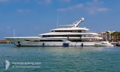
M/Y JOY
Pleasure Craft
Current Trip
| Time Travelled | 1 day |
|---|---|
| Remaining Time | --- |
| Distance Travelled | 341.08 nm |
| Remaining Distance | --- |
| AVG Speed | 11.2 Noeuds |
| MAX Speed | 14.8 Noeuds |
| AVG Wind | 6.6 knots |
| MAX Wind | 23 knots |
| MIN Temp | 15.5°C / 59.9°F |
| MAX Temp | 19.8°C / 67.64°F |
| Tirant d eau | 3 m |
| Position reçue | 2 h, 3 m depuis |
Current Position
| Longitude | 0.31881° |
|---|---|
| Latitude | 38.52578° |
| Etat | Under way using engine |
| Vitesse | 10.2 Noeuds |
| Parcours | 32.7° |
| Zone | Mediterranean Sea - Western Basin |
| Station | T-AIS |
| Position reçue | 2 h, 3 m depuis |
Info
Information
The current position of M/Y JOY is in Mediterranean Sea - Western Basin with coordinates 38.52578° / 0.31881° as reported on 2024-04-19 18:23 by AIS to our vessel tracker app. The vessel's current speed is 10.2 Noeuds and is heading at the port of LA CIOTAT. The estimated time of arrival as calculated by MyShipTracking vessel tracking app is 2024-04-21 13:00 LT
The vessel M/Y JOY (IMO: 1012854, MMSI: 319099200) is a Pleasure Craft It's sailing under the flag of [KY] Cayman Is.
In this page you can find informations about the vessels current position, last detected port calls, and current voyage information. If the vessels is not in coverage by AIS you will find the latest position.
The current position of M/Y JOY is detected by our AIS receivers and we are not responsible for the reliability of the data. The last position was recorded while the vessel was in Coverage by the Ais receivers of our vessel tracking app.
The current draught of M/Y JOY as reported by AIS is 3 meters
Weather
| Temperature | 15.5°C / 59.9°F |
|---|---|
| Wind Speed | 8 knots |
| Direction | 158° SSE |
| Pressure | 1020.1 hPa |
| Humidity | 53.5 % |
| Cloud Coverage | 3 % |
Featured Company
Last Port Calls
| Port | Arrival | Departure | Time In Port |
|---|---|---|---|
| 2024-04-16 07:43 | 2024-04-18 10:17 | 2 d | |
| 2024-02-19 11:51 | 2024-02-20 12:25 | 1 d | |
| 2024-02-18 13:10 |
Most Visited Ports (Last year)
| Port | Arrivals | |
|---|---|---|
| 3 | ||
| 3 | ||
| 3 | ||
| 2 | ||
| 2 | ||
| 1 |
Last Trips
| Origin | Departure | Destination | Arrival | Distance | |
|---|---|---|---|---|---|
| 2024-02-20 08:25 | 2024-04-16 09:43 | 5359.23 nm | |||
| 2024-02-18 09:10 | 2024-02-19 07:51 | 108.19 nm |
Events
| Heure | Evenement | Détails | Position/ Destination | Info |
|---|---|---|---|---|
| 2024-04-19 18:23 | Hors de la zone couverte |
38.52578 / .31881
Mediterranean Sea - Western Basin
FR LCT
|
Vitesse: 10.2 kn Parcours: 32.7° |
|
| 2024-04-19 12:49 | Changement d'ETA | 2024/04/21 13:00 |
37.68037 / -.40129
FR LCT
|
Vitesse: 10.9 kn Parcours: 34° |
| 2024-04-19 12:01 | Changement d'ETA | 2024/04/21 13:00 |
37.56347 / -.51490
FR LCT
|
Vitesse: 10.9 kn Parcours: 38° |
| 2024-04-19 05:19 | Dans la zone couverte |
36.83681 / -1.51363
Mediterranean Sea - Western Basin
FR LCT
|
Vitesse: 9.8 kn Parcours: 47.2° |
|
| 2024-04-19 03:40 | Hors de la zone couverte |
36.66062 / -1.75764
Mediterranean Sea - Western Basin
FR LCT
|
Vitesse: 9.2 kn Parcours: 48.9° |
|
| 2024-04-19 03:40 | Dans la zone couverte |
36.66062 / -1.75764
Mediterranean Sea - Western Basin
FR LCT
|
Vitesse: 9.2 kn Parcours: 48.9° |
|
| 2024-04-19 02:39 | Detecté en mer | Spanish part of the Mediterranean Sea - Western Basin |
36.55708 / -1.90073
Mediterranean Sea - Western Basin
FR LCT
|
Vitesse: 8.9 kn Parcours: 48.8° |
| 2024-04-19 02:39 | Dans la zone couverte |
36.55708 / -1.90073
Mediterranean Sea - Western Basin
FR LCT
|
Vitesse: 8.9 kn Parcours: 48.8° |
|
| 2024-04-19 02:39 | Hors de la zone couverte |
36.55708 / -1.90073
Mediterranean Sea - Western Basin
FR LCT
|
Vitesse: 8.9 kn Parcours: 48.8° |
|
| 2024-04-18 23:49 | Hors de la zone couverte |
36.34090 / -2.40708
Alboran Sea
FR LCT
|
Vitesse: 9.3 kn Parcours: 81° |