
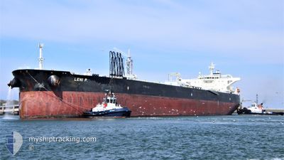
LENI P.
Crude Oil Tanker
Current Trip
| Time Travelled | --- |
|---|---|
| Remaining Time | --- |
| Distance Travelled | 8559.48 nm |
| Remaining Distance | --- |
| AVG Speed | 11.2 Noeuds |
| MAX Speed | 15.1 Noeuds |
| AVG Wind | 8.7 knots |
| MAX Wind | 21 knots |
| MIN Temp | 15.1°C / 59.18°F |
| MAX Temp | 30.2°C / 86.36°F |
| Tirant d eau | 16 m |
| Position reçue | 4 d depuis |
Current Position
| Longitude | --- |
|---|---|
| Latitude | --- |
| Etat | Under way using engine |
| Vitesse | 13 Noeuds |
| Parcours | 175.3° |
| Zone | Gulf of Oman |
| Station | T-AIS |
| Position reçue | 4 d depuis |
Info
Information
The current position of LENI P. is in Gulf of Oman with coordinates 24.91069° / 56.80547° as reported on 2025-12-04 10:26 by AIS to our vessel tracker app. The vessel's current speed is 13 Noeuds and is heading at the port of SIKKA. The estimated time of arrival as calculated by MyShipTracking vessel tracking app is 2025-12-07 08:00 LT
The vessel LENI P. (IMO: 9594133, MMSI: 538008334) is a Crude Oil Tanker that was built in 2011 ( 14 Age ). It's sailing under the flag of [MH] Marshall Is.
In this page you can find informations about the vessels current position, last detected port calls, and current voyage information. If the vessels is not in coverage by AIS you will find the latest position.
The current position of LENI P. is detected by our AIS receivers and we are not responsible for the reliability of the data. The last position was recorded while the vessel was in Coverage by the Ais receivers of our vessel tracking app.
The current draught of LENI P. as reported by AIS is 16 meters
Weather
| Temperature | 24.9°C / 76.82°F |
|---|---|
| Wind Speed | 10 knots |
| Direction | 42° NE |
| Pressure | 1016.1 hPa |
| Humidity | 57.6 % |
| Cloud Coverage | --- |
Featured Company
Last Port Calls
Most Visited Ports (Last year)
| Port | Arrivals | |
|---|---|---|
| 3 | ||
| 1 | ||
| 1 | ||
| 1 | ||
| 1 | ||
| 1 |
Last Trips
| Origin | Departure | Destination | Arrival | Distance |
|---|
Events
| Heure | Evenement | Détails | Position/ Destination | Info |
|---|---|---|---|---|
| 2025-12-08 14:52 | Démarrage | 7.43 nm, North West of SIKKA |
22.57104 / 69.73418
IN SIK
|
Vitesse: 3.9 kn Parcours: 23° |
| 2025-12-07 09:13 | Arret | 5.69 nm, North West of SIKKA |
22.55996 / 69.76526
IN SIK
|
Vitesse: 0.1 kn Parcours: 253° |
| 2025-12-07 08:33 | Démarrage | 6.62 nm, North West of SIKKA |
22.58191 / 69.76665
IN SIK
|
Vitesse: 3.1 kn Parcours: 186° |
| 2025-12-07 08:05 | Arret | 6.92 nm, North West of SIKKA |
22.58654 / 69.76437
IN SIK
|
Vitesse: 0.2 kn Parcours: 249° |
| 2025-12-04 10:31 | Etat Changé | Default Under way using engine |
24.89267 / 56.80706
IN SIK
|
Vitesse: 13 kn Parcours: 175.3° |
| 2025-12-04 10:26 | Hors de la zone couverte |
24.91069 / 56.80547
Gulf of Oman
IN SIK
|
Vitesse: 13 kn Parcours: 175.3° |
|
| 2025-12-04 09:48 | Changement de zone | Omani part of the Gulf of Oman United Arab Emirates part of the Gulf of Oman |
25.04770 / 56.79280
Gulf of Oman
IN SIK
|
Vitesse: 13 kn Parcours: 175.9° |
| 2025-12-04 08:08 | Changement d'ETA | 2025/12/07 02:30 2025/12/07 02:00 |
25.41067 / 56.75216
IN SIK
|
Vitesse: 12.8 kn Parcours: 175.1° |
| 2025-12-04 06:52 | Changement de zone | United Arab Emirates part of the Gulf of Oman Omani part of the Gulf of Oman |
25.67341 / 56.71838
Gulf of Oman
IN SIK
|
Vitesse: 12.2 kn Parcours: 172.2° |
| 2025-12-04 05:37 | Detecté en mer | Omani part of the Gulf of Oman |
25.92193 / 56.68579
Gulf of Oman
IN SIK
|
Vitesse: 11.5 kn Parcours: 173.8° |