
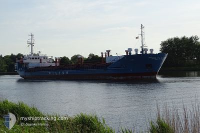
LEIRO
General Cargo
Current Trip
| Time Travelled | 1 day |
|---|---|
| Remaining Time | 1 day |
| Distance Travelled | 163.74 nm |
| Remaining Distance | 467.98 nm |
| AVG Speed | 9.7 Noeuds |
| MAX Speed | 11.4 Noeuds |
| AVG Wind | 15 knots |
| MAX Wind | 32 knots |
| MIN Temp | -10.4°C / 13.28°F |
| MAX Temp | 6.5°C / 43.7°F |
| Tirant d eau | 4.9 m |
| Position reçue | 1 m depuis |
Current Position
| Longitude | 5.37299° |
|---|---|
| Latitude | 59.97610° |
| Etat | Under way using engine |
| Vitesse | 9.2 Noeuds |
| Parcours | 133.2° |
| Zone | North Sea |
| Station | T-AIS |
| Position reçue | 1 m depuis |
Info
Information
The current position of LEIRO is in North Sea with coordinates 59.97610° / 5.37299° as reported on 2024-04-23 20:47 by AIS to our vessel tracker app. The vessel's current speed is 9.2 Noeuds and is heading at the port of NYBORG. The estimated time of arrival as calculated by MyShipTracking vessel tracking app is 2024-04-25 19:52 LT
The vessel LEIRO (IMO: 8017085, MMSI: 314298000) is a General Cargo that was built in 1981 ( 43 Age ). It's sailing under the flag of [BB] Barbados.
In this page you can find informations about the vessels current position, last detected port calls, and current voyage information. If the vessels is not in coverage by AIS you will find the latest position.
The current position of LEIRO is detected by our AIS receivers and we are not responsible for the reliability of the data. The last position was recorded while the vessel was in Coverage by the Ais receivers of our vessel tracking app.
The current draught of LEIRO as reported by AIS is 4.9 meters
Weather
| Temperature | 5.3°C / 41.54°F |
|---|---|
| Wind Speed | 18 knots |
| Direction | 351° N |
| Pressure | 1013.3 hPa |
| Humidity | 78.4 % |
| Cloud Coverage | 48 % |
Featured Company
Last Port Calls
| Port | Arrival | Departure | Time In Port |
|---|---|---|---|
| 2024-04-21 16:10 | 2024-04-22 06:08 | 13 h | |
| 2024-04-18 06:27 | 2024-04-18 18:26 | 11 h | |
| 2024-04-17 10:10 | 2024-04-17 18:46 | 8 h | |
| 2024-04-13 16:47 | 2024-04-15 15:23 | 1 d | |
| 2024-04-12 04:44 | 2024-04-12 19:09 | 14 h | |
| 2024-04-03 16:08 | 2024-04-04 11:38 | 19 h | |
| 2024-04-02 00:09 | 2024-04-03 12:14 | 1 d | |
| 2024-03-29 20:41 | 2024-03-30 07:25 | 10 h | |
| 2024-03-26 20:52 | 2024-03-28 16:30 | 1 d | |
| 2024-03-25 08:09 | 2024-03-25 17:32 | 9 h |
Most Visited Ports (Last year)
| Port | Arrivals | |
|---|---|---|
| 13 | ||
| 10 | ||
| 9 | ||
| 6 | ||
| 6 | ||
| 5 |
Last Trips
| Origin | Departure | Destination | Arrival | Distance | |
|---|---|---|---|---|---|
| 2024-04-18 20:26 | 2024-04-21 18:10 | 605.80 nm | |||
| 2024-04-17 20:46 | 2024-04-18 08:27 | 92.97 nm | |||
| 2024-04-15 17:23 | 2024-04-17 12:10 | 331.71 nm | |||
| 2024-04-12 21:09 | 2024-04-13 18:47 | 42.07 nm | |||
| 2024-04-04 13:38 | 2024-04-12 06:44 | 1195.04 nm | |||
| 2024-04-03 14:14 | 2024-04-03 18:08 | 35.55 nm | |||
| 2024-03-30 08:25 | 2024-04-02 02:09 | 604.29 nm | |||
| 2024-03-28 17:30 | 2024-03-29 21:41 | 255.16 nm | |||
| 2024-03-25 18:32 | 2024-03-26 21:52 | 258.45 nm | |||
| 2024-03-22 22:49 | 2024-03-25 09:09 | 452.26 nm |
Events
| Heure | Evenement | Détails | Position/ Destination | Info |
|---|---|---|---|---|
| 2024-04-23 13:46 | Detecté en mer | Norwegian part of the North Sea |
60.99544 / 4.78548
North Sea
NYBORG
|
Vitesse: 10.5 kn Parcours: 235.6° |
| 2024-04-23 13:24 | Etat Changé | Under way using engine Moored |
61.02945 / 4.90045
NYBORG
|
Vitesse: 10.4 kn Parcours: 237.9° |
| 2024-04-23 12:15 | Démarrage | 4.21 nm, West of LEIRVIK |
61.13804 / 5.19719
NYBORG
|
Vitesse: 3.5 kn Parcours: 187° |
| 2024-04-23 11:07 | Tirant d'eau modifié | 4.9 3.6 |
61.14024 / 5.19993
NYBORG
|
Vitesse: Parcours: 161° |
| 2024-04-23 11:07 | Changement de destination | NYBORG HYLLESTAD |
61.14024 / 5.19993
NYBORG
|
Vitesse: Parcours: 161° |
| 2024-04-23 11:07 | Changement d'ETA | 2024/04/25 21:00 2024/04/22 14:00 |
61.14024 / 5.19993
NYBORG
|
Vitesse: Parcours: 161° |
| 2024-04-22 14:32 | Etat Changé | Moored Under way using engine |
61.14000 / 5.20010
HYLLESTAD
|
Vitesse: Parcours: 163° |
| 2024-04-22 14:10 | Arret | 4.14 nm, West of LEIRVIK |
61.14017 / 5.19991
HYLLESTAD
|
Vitesse: 0.2 kn Parcours: 161° |
| 2024-04-22 12:33 | Changement d'ETA | 2024/04/22 14:00 2024/04/22 16:00 |
61.09700 / 5.57623
HYLLESTAD
|
Vitesse: 10.4 kn Parcours: 250° |
| 2024-04-22 06:08 | PORT DE DEPART |
|
61.23094 / 7.68690
HYLLESTAD
|
Vitesse: 6.7 kn Parcours: 249° |