
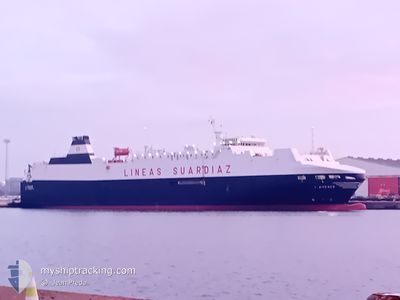
LAUDACE
Vehicles Carrier
Current Trip
| Time Travelled | 1 day |
|---|---|
| Remaining Time | --- |
| Distance Travelled | 217.60 nm |
| Remaining Distance | --- |
| AVG Speed | 10.7 Noeuds |
| MAX Speed | 19.4 Noeuds |
| AVG Wind | 11.1 knots |
| MAX Wind | 36.8 knots |
| MIN Temp | 6.8°C / 44.24°F |
| MAX Temp | 14.1°C / 57.38°F |
| Tirant d eau | 5.2 m |
| Position reçue | Maintenant |
Current Position
| Longitude | 2.18905° |
|---|---|
| Latitude | 41.33115° |
| Etat | Under way using engine |
| Vitesse | 0.4 Noeuds |
| Parcours | 245° |
| Zone | Balearic Sea |
| Station | T-AIS |
| Position reçue | Maintenant |
Info
Information
The current position of LAUDACE is in Balearic Sea with coordinates 41.33115° / 2.18905° as reported on 2024-04-24 17:46 by AIS to our vessel tracker app. The vessel's current speed is 0.4 Noeuds and is heading at the port of BARCELONA. The estimated time of arrival as calculated by MyShipTracking vessel tracking app is 2024-04-23 13:00 LT
The vessel LAUDACE (IMO: 9187318, MMSI: 224876000) is a Vehicles Carrier that was built in 1999 ( 25 Age ). It's sailing under the flag of [ES] Spain.
In this page you can find informations about the vessels current position, last detected port calls, and current voyage information. If the vessels is not in coverage by AIS you will find the latest position.
The current position of LAUDACE is detected by our AIS receivers and we are not responsible for the reliability of the data. The last position was recorded while the vessel was in Coverage by the Ais receivers of our vessel tracking app.
The current draught of LAUDACE as reported by AIS is 5.2 meters
Weather
| Temperature | 14°C / 57.2°F |
|---|---|
| Wind Speed | 8 knots |
| Direction | 177° S |
| Pressure | 1013.6 hPa |
| Humidity | 54.5 % |
| Cloud Coverage | 3 % |
Featured Company
Last Port Calls
| Port | Arrival | Departure | Time In Port |
|---|---|---|---|
| 2024-04-21 22:04 | 2024-04-22 19:12 | 21 h | |
| 2024-04-17 15:16 | 2024-04-18 17:27 | 1 d | |
| 2024-04-15 08:52 | 2024-04-16 11:43 | 1 d | |
| 2024-04-11 23:53 | 2024-04-12 14:15 | 14 h | |
| 2024-03-31 00:51 | 2024-04-08 19:27 | 8 d | |
| 2024-03-27 21:09 | 2024-03-28 17:39 | 20 h | |
| 2024-03-20 10:28 | 2024-03-25 07:51 | 4 d | |
| 2024-03-18 18:36 | 2024-03-19 14:54 | 20 h | |
| 2024-03-15 21:56 | 2024-03-16 13:49 | 15 h | |
| 2024-03-13 05:47 | 2024-03-13 19:10 | 13 h |
Most Visited Ports (Last year)
| Port | Arrivals | |
|---|---|---|
| 18 | ||
| 16 | ||
| 15 | ||
| 15 | ||
| 15 | ||
| 12 |
Last Trips
| Origin | Departure | Destination | Arrival | Distance | |
|---|---|---|---|---|---|
| 2024-04-18 19:27 | 2024-04-22 00:04 | 1273.04 nm | |||
| 2024-04-16 13:43 | 2024-04-17 17:16 | 514.03 nm | |||
| 2024-04-12 14:15 | 2024-04-15 10:52 | 986.18 nm | |||
| 2024-04-08 21:27 | 2024-04-11 23:53 | 1151.46 nm | |||
| 2024-03-28 17:39 | 2024-03-31 01:51 | 988.27 nm | |||
| 2024-03-25 08:51 | 2024-03-27 21:09 | 887.49 nm | |||
| 2024-03-19 15:54 | 2024-03-20 11:28 | 364.88 nm | |||
| 2024-03-16 13:49 | 2024-03-18 19:36 | 985.14 nm | |||
| 2024-03-13 20:10 | 2024-03-15 21:56 | 685.52 nm | |||
| 2024-03-11 11:42 | 2024-03-13 06:47 | 540.54 nm |
Events
| Heure | Evenement | Détails | Position/ Destination | Info |
|---|---|---|---|---|
| 2024-04-23 11:53 | Arret | 1.08 nm, South East of BARCELONA |
41.33008 / 2.18747
ESBCN
|
Vitesse: 0.3 kn Parcours: 88° |
| 2024-04-23 09:43 | Tirant d'eau modifié | 5.2 5.7 |
41.34564 / 2.51721
ESBCN
|
Vitesse: 11.6 kn Parcours: 242.1° |
| 2024-04-23 09:43 | Changement de destination | ESBCN FRFOS |
41.34564 / 2.51721
ESBCN
|
Vitesse: 11.6 kn Parcours: 242.1° |
| 2024-04-23 09:43 | Changement d'ETA | 2024/04/23 13:00 2024/04/22 00:00 |
41.34564 / 2.51721
ESBCN
|
Vitesse: 11.6 kn Parcours: 242.1° |
| 2024-04-23 08:32 | Detecté en mer | Spanish part of the Balearic Sea |
41.49878 / 2.72241
Balearic Sea
|
Vitesse: 11.7 kn Parcours: 214.8° |
| 2024-04-23 08:31 | Etat Changé | Under way using engine Default |
41.50060 / 2.72408
FRFOS
|
Vitesse: 11.8 kn Parcours: 215° |
| 2024-04-23 08:25 | Dans la zone couverte |
41.49878 / 2.72241
Balearic Sea
|
Vitesse: 11.7 kn Parcours: 214.8° |
|
| 2024-04-22 19:28 | Etat Changé | Default Under way using engine |
43.33632 / 4.97296
FRFOS
|
Vitesse: 19.4 kn Parcours: 164° |
| 2024-04-22 19:28 | Etat Changé | Under way using engine Default |
43.33747 / 4.97255
FRFOS
|
Vitesse: 17.7 kn Parcours: 163° |
| 2024-04-22 19:28 | Hors de la zone couverte |
43.33747 / 4.97255
Mediterranean Sea - Western Basin
|
Vitesse: 19.4 kn Parcours: 164° |