
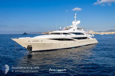
KOLAHA
Yacht
Current Trip
| Trip Time | 7 h, 11 mins |
|---|---|
| Trip Distance | 103.19 nm |
| AVG Speed | 12.8 Noeuds |
| MAX Speed | 16.2 Noeuds |
| Tirant d eau | 3.5 m |
| AVG Wind | 4.2 knots |
| MAX Wind | 8 knots |
| MIN Temp | 15.3°C / 59.54°F |
| MAX Temp | 18.8°C / 65.84°F |
| Position reçue | 2 m depuis |
Current Position
| Longitude | 7.03244° |
|---|---|
| Latitude | 43.53997° |
| Etat | Moored |
| Vitesse | |
| Parcours | 297° |
| Zone | Mediterranean Sea - Western Basin |
| Station | T-AIS |
| Position reçue | 2 m depuis |
Info
Information
The current position of KOLAHA is in Mediterranean Sea - Western Basin with coordinates 43.53997° / 7.03244° as reported on 2024-04-19 21:40 by AIS to our vessel tracker app. The vessel's current speed is 0 Noeuds and is currently inside the port of CANNES.
The vessel KOLAHA (IMO: 1010600, MMSI: 377703000) is a Yacht that was built in 2010 ( 14 Age ). It's sailing under the flag of [VC] St Vincent Grenadines.
In this page you can find informations about the vessels current position, last detected port calls, and current voyage information. If the vessels is not in coverage by AIS you will find the latest position.
The current position of KOLAHA is detected by our AIS receivers and we are not responsible for the reliability of the data. The last position was recorded while the vessel was in Coverage by the Ais receivers of our vessel tracking app.
The current draught of KOLAHA as reported by AIS is 3.5 meters
Weather
| Temperature | 13.7°C / 56.66°F |
|---|---|
| Wind Speed | 2 knots |
| Direction | 260° W |
| Pressure | 1009 hPa |
| Humidity | 54.3 % |
| Cloud Coverage | 3 % |
Featured Company
Events
| Heure | Evenement | Détails | Position/ Destination | Info |
|---|---|---|---|---|
| 2024-04-12 13:07 | Etat Changé | Moored Under way using engine |
43.53997 / 7.03243
[FR] CANNES
|
Vitesse: Parcours: 298° |
| 2024-04-12 12:46 | Arret |
43.54225 / 7.03056
[FR] CANNES
|
Vitesse: 0.2 kn Parcours: 14° |
|
| 2024-04-12 12:44 | Port d'arrivée |
|
43.54155 / 7.02891
[FR] CANNES
|
Vitesse: 7.5 kn Parcours: 59° |
| 2024-04-12 12:39 | Démarrage | 0.6 nm, South West of CANNES |
43.53593 / 7.01586
FRCEQ
|
Vitesse: 5.4 kn Parcours: 78.5° |
| 2024-04-12 12:23 | Arret | 0.66 nm, South West of CANNES |
43.53636 / 7.01337
FRCEQ
|
Vitesse: 0.2 kn Parcours: 140° |
| 2024-04-12 10:46 | Changement de zone | French part of the Mediterranean Sea - Western Basin Mon�gasque part of the Mediterranean Sea - Western Basin |
43.62765 / 7.45544
Mediterranean Sea - Western Basin
FRCEQ
|
Vitesse: 15 kn Parcours: 244.4° |
| 2024-04-12 10:43 | Changement de zone | Mon�gasque part of the Mediterranean Sea - Western Basin Italian part of the Ligurian Sea |
43.63238 / 7.46910
Mediterranean Sea - Western Basin
FRCEQ
|
Vitesse: 15.2 kn Parcours: 244.2° |
| 2024-04-12 10:41 | Dans la zone couverte |
43.63238 / 7.46910
Mediterranean Sea - Western Basin
FRCEQ
|
Vitesse: 15.2 kn Parcours: 244.2° |
|
| 2024-04-12 06:35 | Hors de la zone couverte |
44.19923 / 8.72895
Ligurian Sea
FRCEQ
|
Vitesse: 16 kn Parcours: 217.8° |
|
| 2024-04-12 05:33 | PORT DE DEPART |
|
44.38452 / 8.94212
FRCEQ
|
Vitesse: 11.5 kn Parcours: 164° |