
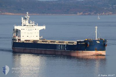
IONIC KLEOS
Bulk Carrier
Current Trip
| Time Travelled | 26 days |
|---|---|
| Remaining Time | --- |
| Distance Travelled | 3738.79 nm |
| Remaining Distance | --- |
| AVG Speed | 11.2 Noeuds |
| MAX Speed | 15 Noeuds |
| AVG Wind | 8.3 knots |
| MAX Wind | 21 knots |
| MIN Temp | 24.9°C / 76.82°F |
| MAX Temp | 31.1°C / 87.98°F |
| Tirant d eau | 14.7 m |
| Position reçue | 6 h, 37 m depuis |
Current Position
| Longitude | 117.10969° |
|---|---|
| Latitude | -1.34390° |
| Etat | Under way using engine |
| Vitesse | 11 Noeuds |
| Parcours | 74.4° |
| Zone | Makassar Strait |
| Station | T-AIS |
| Position reçue | 6 h, 37 m depuis |
Info
Information
The current position of IONIC KLEOS is in Makassar Strait with coordinates -1.34390° / 117.10969° as reported on 2024-04-25 10:26 by AIS to our vessel tracker app. The vessel's current speed is 11 Noeuds and is heading at the port of MARIVELES. The estimated time of arrival as calculated by MyShipTracking vessel tracking app is 2024-04-29 20:00 LT
The vessel IONIC KLEOS (IMO: 9470507, MMSI: 538005444) is a Bulk Carrier that was built in 2014 ( 10 Age ). It's sailing under the flag of [MH] Marshall Is.
In this page you can find informations about the vessels current position, last detected port calls, and current voyage information. If the vessels is not in coverage by AIS you will find the latest position.
The current position of IONIC KLEOS is detected by our AIS receivers and we are not responsible for the reliability of the data. The last position was recorded while the vessel was in Coverage by the Ais receivers of our vessel tracking app.
The current draught of IONIC KLEOS as reported by AIS is 14.7 meters
Weather
| Temperature | 28.9°C / 84.02°F |
|---|---|
| Wind Speed | 10 knots |
| Direction | 52° NE |
| Pressure | 1008.2 hPa |
| Humidity | 77 % |
| Cloud Coverage | 58 % |
Featured Company
Events
| Heure | Evenement | Détails | Position/ Destination | Info |
|---|---|---|---|---|
| 2024-04-25 10:32 | Etat Changé | Default Under way using engine |
-1.33833 / 117.12666
PH MVS
|
Vitesse: 11 kn Parcours: 74.4° |
| 2024-04-25 10:26 | Hors de la zone couverte |
-1.34390 / 117.10969
Makassar Strait
PH MVS
|
Vitesse: 11 kn Parcours: 74.4° |
|
| 2024-04-25 10:11 | Changement d'ETA | 2024/04/29 20:00 2024/04/28 20:00 |
-1.35648 / 117.06335
PH MVS
|
Vitesse: 10.7 kn Parcours: 75.7° |
| 2024-04-25 09:36 | Démarrage | 11.7 nm, South East of BALIKPAPAN |
-1.35651 / 116.98074
PH MVS
|
Vitesse: 3.1 kn Parcours: 103° |
| 2024-04-25 09:30 | Etat Changé | Under way using engine At anchor |
-1.35871 / 116.97865
PH MVS
|
Vitesse: 0.1 kn Parcours: 25° |
| 2024-04-25 08:03 | Etat Changé | At anchor Default |
-1.35882 / 116.97953
PH MVS
|
Vitesse: Parcours: -1° |
| 2024-04-25 07:59 | Etat Changé | Default At anchor |
-1.35833 / 116.97833
PH MVS
|
Vitesse: Parcours: 62° |
| 2024-04-25 06:42 | Etat Changé | At anchor Default |
-1.35911 / 116.97976
PH MVS
|
Vitesse: Parcours: -1° |
| 2024-04-25 06:38 | Etat Changé | Default At anchor |
-1.35833 / 116.97833
PH MVS
|
Vitesse: Parcours: 53° |
| 2024-04-25 03:54 | Etat Changé | At anchor Under way using engine |
-1.35692 / 116.97881
PH MVS
|
Vitesse: 0.9 kn Parcours: 110° |