
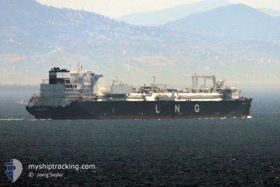
ENERGOS POWER
Tanker
Current Trip
| Trip Time | --- |
|---|---|
| Trip Distance | --- |
| AVG Speed | --- |
| MAX Speed | --- |
| Tirant d eau | --- |
| AVG Wind | --- |
| MAX Wind | --- |
| MIN Temp | --- |
| MAX Temp | --- |
| Position reçue | 2 d depuis |
Current Position
| Longitude | 13.59796° |
|---|---|
| Latitude | 54.48047° |
| Etat | Moored |
| Vitesse | |
| Parcours | 196° |
| Zone | Baltic Sea |
| Station | T-AIS |
| Position reçue | 2 d depuis |
Info
Information
The current position of ENERGOS POWER is in Baltic Sea with coordinates 54.48047° / 13.59796° as reported on 2024-04-15 21:36 by AIS to our vessel tracker app. The vessel's current speed is 0 Noeuds and is currently inside the port of MUKRAN.
The vessel ENERGOS POWER (IMO: 9861809, MMSI: 215888000) is a Tanker It's sailing under the flag of [MT] Malta.
In this page you can find informations about the vessels current position, last detected port calls, and current voyage information. If the vessels is not in coverage by AIS you will find the latest position.
The current position of ENERGOS POWER is detected by our AIS receivers and we are not responsible for the reliability of the data. The last position was recorded while the vessel was in Coverage by the Ais receivers of our vessel tracking app.
The current draught of ENERGOS POWER as reported by AIS is 11.2 meters
Weather
| Temperature | 6.2°C / 43.16°F |
|---|---|
| Wind Speed | 20 knots |
| Direction | 99° E |
| Pressure | 994.4 hPa |
| Humidity | 95.8 % |
| Cloud Coverage | 99 % |
Featured Company
Last Port Calls
| Port | Arrival | Departure | Time In Port |
|---|---|---|---|
| 2024-02-24 08:03 | |||
| 2024-02-18 21:25 | |||
| 2024-02-16 02:16 | 2024-02-16 20:53 | 18 h | |
| 2024-02-12 04:29 | 2024-02-14 06:58 | 2 d | |
| 2024-02-03 04:56 | 2024-02-08 15:59 | 5 d |
Most Visited Ports (Last year)
| Port | Arrivals | |
|---|---|---|
| 3 | ||
| 2 | ||
| 1 | ||
| 1 | ||
| 1 | ||
| 1 |
Last Trips
| Origin | Departure | Destination | Arrival | Distance | |
|---|---|---|---|---|---|
| 2024-02-16 21:53 | 2024-02-18 22:25 | 706.62 nm | |||
| 2024-02-14 07:58 | 2024-02-16 03:16 | 642.46 nm | |||
| 2024-02-08 16:59 | 2024-02-12 05:29 | 1284.92 nm | |||
| 2024-01-01 20:06 | 2024-02-03 05:56 | 10488.61 nm |
Events
| Heure | Evenement | Détails | Position/ Destination | Info |
|---|---|---|---|---|
| 2024-04-15 21:36 | Hors de la zone couverte |
54.48047 / 13.59796
Baltic Sea
[DE] MUKRAN
|
Vitesse: Parcours: 160.8° |
|
| 2024-04-15 20:54 | Dans la zone couverte |
54.48048 / 13.59797
Baltic Sea
[DE] MUKRAN
|
Vitesse: Parcours: 160.8° |
|
| 2024-04-15 17:45 | Hors de la zone couverte |
54.48049 / 13.59798
Baltic Sea
[DE] MUKRAN
|
Vitesse: Parcours: 160.8° |
|
| 2024-04-15 14:42 | Dans la zone couverte |
54.48047 / 13.59795
Baltic Sea
[DE] MUKRAN
|
Vitesse: Parcours: 160.8° |
|
| 2024-04-15 13:09 | Hors de la zone couverte |
54.48048 / 13.59796
Baltic Sea
[DE] MUKRAN
|
Vitesse: Parcours: 160.8° |
|
| 2024-04-15 13:09 | Dans la zone couverte |
54.48048 / 13.59796
Baltic Sea
[DE] MUKRAN
|
Vitesse: Parcours: 160.8° |
|
| 2024-04-13 23:39 | Hors de la zone couverte |
54.48047 / 13.59796
Baltic Sea
[DE] MUKRAN
|
Vitesse: Parcours: 160.8° |
|
| 2024-04-13 23:36 | Dans la zone couverte |
54.48049 / 13.59795
Baltic Sea
[DE] MUKRAN
|
Vitesse: Parcours: 160.8° |
|
| 2024-04-13 18:57 | Hors de la zone couverte |
54.48047 / 13.59797
Baltic Sea
[DE] MUKRAN
|
Vitesse: Parcours: 160.8° |
|
| 2024-04-13 17:33 | Dans la zone couverte |
54.48049 / 13.59796
Baltic Sea
[DE] MUKRAN
|
Vitesse: Parcours: 160.8° |