
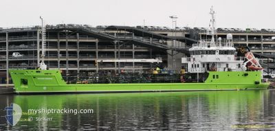
BIO NAVIGATOR
Oil Products Tanker
Current Trip
| Trip Time | 11 h, 35 mins |
|---|---|
| Trip Distance | 84.17 nm |
| AVG Speed | 8.4 Noeuds |
| MAX Speed | 10.1 Noeuds |
| Tirant d eau | 4.2 m |
| AVG Wind | 6.7 knots |
| MAX Wind | 17 knots |
| MIN Temp | 6.5°C / 43.7°F |
| MAX Temp | 8.2°C / 46.76°F |
| Position reçue | Maintenant |
Current Position
| Longitude | 5.31571° |
|---|---|
| Latitude | 59.28368° |
| Etat | Under way using engine |
| Vitesse | |
| Parcours | 84° |
| Zone | North Sea |
| Station | T-AIS |
| Position reçue | Maintenant |
Info
Information
The current position of BIO NAVIGATOR is in North Sea with coordinates 59.28368° / 5.31571° as reported on 2024-04-19 05:40 by AIS to our vessel tracker app. The vessel's current speed is 0 Noeuds and is currently inside the port of KOPERVIK.
The vessel BIO NAVIGATOR (IMO: 9535400, MMSI: 259001980) is a Oil Products Tanker that was built in 2010 ( 14 Age ). It's sailing under the flag of [NO] Norway.
In this page you can find informations about the vessels current position, last detected port calls, and current voyage information. If the vessels is not in coverage by AIS you will find the latest position.
The current position of BIO NAVIGATOR is detected by our AIS receivers and we are not responsible for the reliability of the data. The last position was recorded while the vessel was in Coverage by the Ais receivers of our vessel tracking app.
The current draught of BIO NAVIGATOR as reported by AIS is 4.2 meters
Weather
| Temperature | 4.5°C / 40.1°F |
|---|---|
| Wind Speed | 14 knots |
| Direction | 126° SE |
| Pressure | 1004.4 hPa |
| Humidity | 65.1 % |
| Cloud Coverage | 100 % |
Featured Company
Last Port Calls
| Port | Arrival | Departure | Time In Port |
|---|---|---|---|
| 2024-04-12 14:51 | |||
| 2024-04-09 11:30 | 2024-04-12 03:16 | 2 d | |
| 2024-04-08 03:23 | 2024-04-08 13:26 | 10 h | |
| 2024-04-06 22:19 | 2024-04-07 13:20 | 15 h | |
| 2024-03-21 21:50 | 2024-03-23 07:34 | 1 d | |
| 2024-03-20 18:40 | 2024-03-20 20:30 | 1 h | |
| 2024-03-05 17:50 | 2024-03-09 07:05 | 3 d | |
| 2024-02-29 05:12 | 2024-03-01 06:10 | 1 d | |
| 2024-02-26 23:25 | 2024-02-28 09:02 | 1 d | |
| 2024-02-26 09:26 | 2024-02-26 20:13 | 10 h |
Last Trips
| Origin | Departure | Destination | Arrival | Distance | |
|---|---|---|---|---|---|
| 2024-04-12 05:16 | 2024-04-12 16:51 | 84.17 nm | |||
| 2024-04-08 15:26 | 2024-04-09 13:30 | 202.88 nm | |||
| 2024-04-07 15:20 | 2024-04-08 05:23 | 136.07 nm | |||
| 2024-03-23 08:34 | 2024-04-07 00:19 | 522.78 nm | |||
| 2024-03-20 21:30 | 2024-03-21 22:50 | 208.62 nm | |||
| 2024-03-09 08:05 | 2024-03-20 19:40 | 104.10 nm | |||
| 2024-03-01 07:10 | 2024-03-05 18:50 | 369.42 nm | |||
| 2024-02-28 10:02 | 2024-02-29 06:12 | 155.75 nm | |||
| 2024-02-26 21:13 | 2024-02-27 00:25 | 27.73 nm | |||
| 2024-02-26 07:11 | 2024-02-26 10:26 | 27.39 nm |
Events
| Heure | Evenement | Détails | Position/ Destination | Info |
|---|---|---|---|---|
| 2024-04-12 14:58 | Arret |
59.28350 / 5.31561
[NO] KOPERVIK
|
Vitesse: 0.3 kn Parcours: 74° |
|
| 2024-04-12 14:51 | Port d'arrivée |
|
59.28427 / 5.31792
[NO] KOPERVIK
|
Vitesse: 1.5 kn Parcours: 166° |
| 2024-04-12 12:21 | Démarrage | 5.51 nm, East of KAARSTO |
59.28781 / 5.67844
FISHFARMS
|
Vitesse: 8.3 kn Parcours: 120.8° |
| 2024-04-12 11:56 | Arret | 5.37 nm, East of KAARSTO |
59.29145 / 5.67243
FISHFARMS
|
Vitesse: Parcours: 113° |
| 2024-04-12 09:28 | Démarrage | 4.83 nm, East of VASSOY |
58.97693 / 5.93136
FISHFARMS
|
Vitesse: 7.4 kn Parcours: 288.9° |
| 2024-04-12 08:48 | Arret | 4.96 nm, East of VASSOY |
58.97620 / 5.93533
FISHFARMS
|
Vitesse: 0.2 kn Parcours: 200° |
| 2024-04-12 06:44 | Démarrage | 2.77 nm, North West of JUDABERG |
59.19975 / 5.80942
FISHFARMS
|
Vitesse: 7.6 kn Parcours: 54.1° |
| 2024-04-12 06:17 | Arret | 2.67 nm, North West of JUDABERG |
59.19523 / 5.80713
FISHFARMS
|
Vitesse: 0.1 kn Parcours: 239° |
| 2024-04-12 03:16 | PORT DE DEPART |
|
59.28455 / 5.32080
FISHFARMS
|
Vitesse: 5.4 kn Parcours: 62° |
| 2024-04-12 03:16 | Démarrage |
59.28431 / 5.31995
[NO] KOPERVIK
|
Vitesse: 5.4 kn Parcours: 62° |