
GRIP SOLAR
Tanker
Current Trip
FISH FARM
| Time Travelled | 12 h, 54 mins |
|---|---|
| Remaining Time | --- |
| Distance Travelled | 24.75 nm |
| Remaining Distance | --- |
| AVG Speed | 8.9 Noeuds |
| MAX Speed | 10 Noeuds |
| AVG Wind | 9.6 knots |
| MAX Wind | 13 knots |
| MIN Temp | -4.9°C / 23.18°F |
| MAX Temp | 1.7°C / 35.06°F |
| Tirant d eau | 3 m |
| Position reçue | 2 m depuis |
Current Position
| Longitude | 16.90467° |
|---|---|
| Latitude | 69.15290° |
| Etat | Under way using engine |
| Vitesse | 0.1 Noeuds |
| Parcours | 84° |
| Zone | Norwegian Sea |
| Station | T-AIS |
| Position reçue | 2 m depuis |
Info
Information
The current position of GRIP SOLAR is in Norwegian Sea with coordinates 69.15290° / 16.90467° as reported on 2024-04-19 04:23 by AIS to our vessel tracker app. The vessel's current speed is 0.1 Noeuds
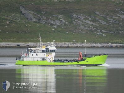
The vessel GRIP SOLAR (MMSI: 257230800) is a Tanker It's sailing under the flag of [NO] Norway.
In this page you can find informations about the vessels current position, last detected port calls, and current voyage information. If the vessels is not in coverage by AIS you will find the latest position.
The current position of GRIP SOLAR is detected by our AIS receivers and we are not responsible for the reliability of the data. The last position was recorded while the vessel was in Coverage by the Ais receivers of our vessel tracking app.
The current draught of GRIP SOLAR as reported by AIS is 3 meters
Weather
| Temperature | -6.4°C / 20.48°F |
|---|---|
| Wind Speed | 9 knots |
| Direction | 120° ESE |
| Pressure | 1013.2 hPa |
| Humidity | 81.5 % |
| Cloud Coverage | 89 % |
Featured Company
Last Port Calls
| Port | Arrival | Departure | Time In Port |
|---|---|---|---|
| 2024-04-18 13:56 | 2024-04-18 15:32 | 1 h | |
| 2024-04-15 21:56 | 2024-04-17 13:34 | 1 d | |
| 2024-04-14 19:58 | 2024-04-15 06:00 | 10 h | |
| 2024-04-13 13:28 | 2024-04-13 14:07 | 39 m | |
| 2024-04-11 20:22 | 2024-04-12 09:12 | 12 h | |
| 2024-04-10 08:25 | 2024-04-11 15:18 | 1 d | |
| 2024-04-04 15:19 | 2024-04-04 17:19 | 2 h | |
| 2024-04-03 16:48 | 2024-04-04 04:46 | 11 h | |
| 2024-03-30 11:31 | 2024-04-01 10:18 | 1 d | |
| 2024-03-29 19:43 | 2024-03-30 09:24 | 13 h |
Last Trips
| Origin | Departure | Destination | Arrival | Distance | |
|---|---|---|---|---|---|
| 2024-04-17 15:34 | 2024-04-18 15:56 | 136.22 nm | |||
| 2024-04-15 08:00 | 2024-04-15 23:56 | 143.47 nm | |||
| 2024-04-13 16:07 | 2024-04-14 21:58 | 134.65 nm | |||
| 2024-04-12 11:12 | 2024-04-13 15:28 | 136.94 nm | |||
| 2024-04-11 17:18 | 2024-04-11 22:22 | 49.90 nm | |||
| 2024-04-04 19:19 | 2024-04-10 10:25 | 428.04 nm | |||
| 2024-04-04 06:46 | 2024-04-04 17:19 | 76.89 nm | |||
| 2024-04-01 12:18 | 2024-04-03 18:48 | 112.04 nm | |||
| 2024-03-30 10:24 | 2024-03-30 12:31 | 15.61 nm | |||
| 2024-03-29 12:00 | 2024-03-29 20:43 | 68.50 nm |
Events
| Heure | Evenement | Détails | Position/ Destination | Info |
|---|---|---|---|---|
| 2024-04-18 20:45 | Arret | 13.18 nm, South of GRYLLEFJORD |
69.15289 / 16.90479
FISH FARM
|
Vitesse: Parcours: 89° |
| 2024-04-18 19:06 | Démarrage | 0.81 nm, South East of SANDSOYA |
68.93229 / 16.69866
FISH FARM
|
Vitesse: 9.7 kn Parcours: 19.6° |
| 2024-04-18 18:10 | Arret | 0.88 nm, South East of SANDSOYA |
68.93025 / 16.69754
FISH FARM
|
Vitesse: Parcours: 354° |
| 2024-04-18 17:57 | Démarrage | 1.57 nm, South of SANDSOYA |
68.91612 / 16.65142
FISH FARM
|
Vitesse: 9.4 kn Parcours: 56.3° |
| 2024-04-18 17:14 | Arret | 1.91 nm, South of SANDSOYA |
68.91157 / 16.64021
FISH FARM
|
Vitesse: 0.2 kn Parcours: 265° |
| 2024-04-18 16:36 | Démarrage | 4.64 nm, South of SANDSOYA |
68.86413 / 16.67258
FISH FARM
|
Vitesse: 6.5 kn Parcours: 198.5° |
| 2024-04-18 16:03 | Arret | 4.53 nm, South of SANDSOYA |
68.86606 / 16.67354
FISH FARM
|
Vitesse: 0.3 kn Parcours: 191° |
| 2024-04-18 15:32 | PORT DE DEPART |
|
68.80633 / 16.57752
FISH FARM
|
Vitesse: 9.5 kn Parcours: 21° |
| 2024-04-18 15:30 | Démarrage |
68.80164 / 16.57112
[NO] HARSTAD
|
Vitesse: 9.5 kn Parcours: 21° |
|
| 2024-04-18 14:19 | Arret |
68.79850 / 16.56723
[NO] HARSTAD
|
Vitesse: 0.3 kn Parcours: 82° |