
GHINAH
Tanker
Current Trip
OGLA USA
| Time Travelled | 26 days |
|---|---|
| Remaining Time | --- |
| Distance Travelled | 6931.14 nm |
| Remaining Distance | --- |
| AVG Speed | 11.3 Noeuds |
| MAX Speed | 11.3 Noeuds |
| AVG Wind | 13.3 knots |
| MAX Wind | 39.6 knots |
| MIN Temp | 16.3°C / 61.34°F |
| MAX Temp | 29.9°C / 85.82°F |
| Tirant d eau | 21.2 m |
| Position reçue | 9 d depuis |
Current Position
| Longitude | 31.21224° |
|---|---|
| Latitude | -30.05118° |
| Etat | Under way using engine |
| Vitesse | 13.9 Noeuds |
| Parcours | 155.3° |
| Zone | Indian Ocean |
| Station | T-AIS |
| Position reçue | 9 d depuis |
Info
Information
The current position of GHINAH is in Indian Ocean with coordinates -30.05118° / 31.21224° as reported on 2024-04-09 07:52 by AIS to our vessel tracker app. The vessel's current speed is 13.9 Noeuds
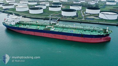
The vessel GHINAH (IMO: 9484728, MMSI: 403638000) is a Tanker It's sailing under the flag of [SA] Saudi Arabia.
In this page you can find informations about the vessels current position, last detected port calls, and current voyage information. If the vessels is not in coverage by AIS you will find the latest position.
The current position of GHINAH is detected by our AIS receivers and we are not responsible for the reliability of the data. The last position was recorded while the vessel was in Coverage by the Ais receivers of our vessel tracking app.
The current draught of GHINAH as reported by AIS is 21.2 meters
Weather
| Temperature | 23.7°C / 74.66°F |
|---|---|
| Wind Speed | 15 knots |
| Direction | 334° NNW |
| Pressure | 1013.2 hPa |
| Humidity | 81.8 % |
| Cloud Coverage | 87 % |
Featured Company
Last Port Calls
| Port | Arrival | Departure | Time In Port |
|---|---|---|---|
| 2024-03-22 07:39 | 2024-03-23 08:45 | 1 d | |
| 2024-02-24 22:52 | 2024-02-26 07:59 | 1 d | |
| 2024-02-14 19:11 | 2024-02-16 04:28 | 1 d | |
| 2024-02-05 14:59 |
Most Visited Ports (Last year)
| Port | Arrivals | |
|---|---|---|
| 3 | ||
| 3 | ||
| 1 |
Last Trips
| Origin | Departure | Destination | Arrival | Distance | |
|---|---|---|---|---|---|
| 2024-02-26 10:59 | 2024-03-22 10:39 | 3735.52 nm | |||
| 2024-02-16 07:28 | 2024-02-25 01:52 | 1182.54 nm | |||
| 2024-02-05 17:59 | 2024-02-14 22:11 | 1167.99 nm |
Events
| Heure | Evenement | Détails | Position/ Destination | Info |
|---|---|---|---|---|
| 2024-04-09 07:57 | Etat Changé | Default Under way using engine |
-30.07012 / 31.22166
OGLA USA
|
Vitesse: 13.9 kn Parcours: 155.3° |
| 2024-04-09 07:52 | Hors de la zone couverte |
-30.05118 / 31.21224
Indian Ocean
OGLA USA
|
Vitesse: 13.9 kn Parcours: 155.3° |
|
| 2024-04-09 07:30 | Etat Changé | Under way using engine Default |
-29.97206 / 31.17625
OGLA USA
|
Vitesse: 12.4 kn Parcours: 161° |
| 2024-04-09 07:12 | Etat Changé | Default Under way using engine |
-29.92357 / 31.15759
OGLA USA
|
Vitesse: 3.1 kn Parcours: 159° |
| 2024-04-09 07:03 | Etat Changé | Under way using engine Default |
-29.91377 / 31.15422
OGLA USA
|
Vitesse: 3 kn Parcours: 170° |
| 2024-04-09 06:47 | Etat Changé | Default Under way using engine |
-29.90013 / 31.15162
OGLA USA
|
Vitesse: 3.3 kn Parcours: 162° |
| 2024-04-09 06:12 | Etat Changé | Under way using engine Default |
-29.86470 / 31.16409
OGLA USA
|
Vitesse: 6.7 kn Parcours: 221° |
| 2024-04-09 06:08 | Etat Changé | Default Under way using engine |
-29.85912 / 31.16916
OGLA USA
|
Vitesse: 7 kn Parcours: 229.4° |
| 2024-04-09 05:40 | Etat Changé | Under way using engine Default |
-29.83030 / 31.22113
OGLA USA
|
Vitesse: 6.1 kn Parcours: 242° |
| 2024-04-09 05:25 | Etat Changé | Default Under way using engine |
-29.81882 / 31.24866
OGLA USA
|
Vitesse: 5.9 kn Parcours: 247.5° |