
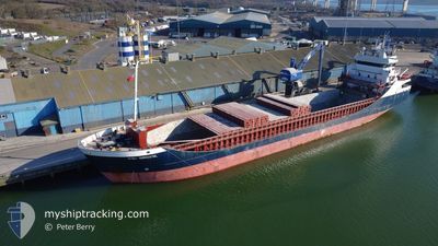
FRI BREVIK
General Cargo
Current Trip
| Time Travelled | 3 days |
|---|---|
| Remaining Time | 6 h, 36 mins |
| Distance Travelled | 850.25 nm |
| Remaining Distance | 45.86 nm |
| AVG Speed | 9.8 Noeuds |
| MAX Speed | 15.7 Noeuds |
| AVG Wind | 15.7 knots |
| MAX Wind | 33.5 knots |
| MIN Temp | 4.1°C / 39.38°F |
| MAX Temp | 12.2°C / 53.96°F |
| Tirant d eau | 5.8 m |
| Position reçue | Maintenant |
Current Position
| Longitude | --- |
|---|---|
| Latitude | --- |
| Etat | Under way using engine |
| Vitesse | 6.1 Noeuds |
| Parcours | 253.8° |
| Zone | North Sea |
| Station | T-AIS |
| Position reçue | Maintenant |
Info
Information
The current position of FRI BREVIK is in North Sea with coordinates 51.48667° / 1.43617° as reported on 2025-12-09 08:05 by AIS to our vessel tracker app. The vessel's current speed is 6.1 Noeuds and is heading at the port of NORTHFLEET. The estimated time of arrival as calculated by MyShipTracking vessel tracking app is 2025-12-09 14:41 LT
The vessel FRI BREVIK (IMO: 9190183, MMSI: 209488000) is a General Cargo that was built in 2001 ( 24 Age ). It's sailing under the flag of [CY] Cyprus.
In this page you can find informations about the vessels current position, last detected port calls, and current voyage information. If the vessels is not in coverage by AIS you will find the latest position.
The current position of FRI BREVIK is detected by our AIS receivers and we are not responsible for the reliability of the data. The last position was recorded while the vessel was in Coverage by the Ais receivers of our vessel tracking app.
The current draught of FRI BREVIK as reported by AIS is 5.8 meters
Weather
| Temperature | 11.6°C / 52.88°F |
|---|---|
| Wind Speed | 24 knots |
| Direction | 187° S |
| Pressure | 1006.2 hPa |
| Humidity | 92.7 % |
| Cloud Coverage | 100 % |
Featured Company
Last Port Calls
| Port | Arrival | Departure | Time In Port |
|---|---|---|---|
| 2025-12-04 21:26 | 2025-12-05 19:10 | 21 h | |
| 2025-12-02 09:31 | 2025-12-04 12:26 | 2 d | |
| 2025-11-27 03:23 | 2025-11-28 16:48 | 1 d | |
| 2025-11-25 01:48 | 2025-11-26 19:30 | 1 d | |
| 2025-11-18 06:23 | 2025-11-18 21:22 | 14 h | |
| 2025-11-12 06:52 | 2025-11-13 01:20 | 18 h | |
| 2025-11-02 15:59 | 2025-11-04 17:37 | 2 d | |
| 2025-10-29 16:26 | 2025-11-01 18:24 | 3 d | |
| 2025-10-27 08:17 | 2025-10-28 16:10 | 1 d | |
| 2025-10-19 09:27 | 2025-10-24 08:22 | 4 d |
Last Trips
| Origin | Departure | Destination | Arrival | Distance | |
|---|---|---|---|---|---|
| 2025-12-04 12:26 | 2025-12-04 21:26 | 66.42 nm | |||
| 2025-11-28 16:48 | 2025-12-02 09:31 | 799.10 nm | |||
| 2025-11-26 19:30 | 2025-11-27 03:23 | 79.19 nm | |||
| 2025-11-18 21:22 | 2025-11-25 01:48 | 1208.56 nm | |||
| 2025-11-13 01:20 | 2025-11-18 06:23 | 925.59 nm | |||
| 2025-11-04 17:37 | 2025-11-12 06:52 | 1705.82 nm | |||
| 2025-11-01 18:24 | 2025-11-02 15:59 | 217.88 nm | |||
| 2025-10-28 16:10 | 2025-10-29 16:26 | 159.36 nm | |||
| 2025-10-24 08:22 | 2025-10-27 08:17 | 598.42 nm | |||
| 2025-10-15 05:38 | 2025-10-19 09:27 | 760.40 nm |
Events
| Heure | Evenement | Détails | Position/ Destination | Info |
|---|---|---|---|---|
| 2025-12-09 01:40 | Etat Changé | Under way using engine Default |
52.24316 / 1.81967
GBNFT
|
Vitesse: 10.4 kn Parcours: 190° |
| 2025-12-09 01:25 | Dans la zone couverte |
52.24316 / 1.81967
North Sea
GBNFT
|
Vitesse: 10.3 kn Parcours: 190° |
|
| 2025-12-08 23:29 | Etat Changé | Default Under way using engine |
52.65983 / 1.91150
GBNFT
|
Vitesse: 12.7 kn Parcours: 149° |
| 2025-12-08 23:23 | Hors de la zone couverte |
52.68050 / 1.90500
North Sea
GBNFT
|
Vitesse: 12.7 kn Parcours: 149° |
|
| 2025-12-08 20:22 | Etat Changé | Under way using engine Default |
53.05218 / 1.06241
GBNFT
|
Vitesse: 12 kn Parcours: 128° |
| 2025-12-08 20:05 | Dans la zone couverte |
53.05218 / 1.06241
North Sea
GBNFT
|
Vitesse: 11.9 kn Parcours: 125.1° |
|
| 2025-12-08 15:41 | Etat Changé | Default Under way using engine |
53.83850 / .33383
GBNFT
|
Vitesse: 10.7 kn Parcours: 160.4° |
| 2025-12-08 15:35 | Hors de la zone couverte |
53.85550 / .32467
North Sea
GBNFT
|
Vitesse: 10.7 kn Parcours: 160.4° |
|
| 2025-12-08 13:36 | Etat Changé | Under way using engine Default |
54.16484 / .12617
GBNFT
|
Vitesse: 9.3 kn Parcours: 160° |
| 2025-12-08 13:17 | Dans la zone couverte |
54.16484 / .12617
North Sea
GBNFT
|
Vitesse: 9.2 kn Parcours: 159.2° |