
ESL EUROPA
General Cargo
Current Trip
| Trip Time | 8 days |
|---|---|
| Trip Distance | 2498.67 nm |
| AVG Speed | 11.9 Noeuds |
| MAX Speed | 15 Noeuds |
| Tirant d eau | 9.8 m |
| AVG Wind | 11.3 knots |
| MAX Wind | 33 knots |
| MIN Temp | 15.8°C / 60.44°F |
| MAX Temp | 33.8°C / 92.84°F |
| Position reçue | 8 d depuis |
Current Position
| Longitude | -17.70707° |
|---|---|
| Latitude | 20.61584° |
| Etat | Under way using engine |
| Vitesse | 13.2 Noeuds |
| Parcours | 183.1° |
| Zone | North Atlantic Ocean |
| Station | T-AIS |
| Position reçue | 8 d depuis |
Info
Information
The current position of ESL EUROPA is in North Atlantic Ocean with coordinates 20.61584° / -17.70707° as reported on 2024-04-11 06:21 by AIS to our vessel tracker app. The vessel's current speed is 13.2 Noeuds and is currently inside the port of LAGOS.
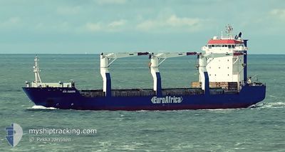
The vessel ESL EUROPA (IMO: 9333553, MMSI: 212667000) is a General Cargo that was built in 2007 ( 17 Age ). It's sailing under the flag of [CY] Cyprus.
In this page you can find informations about the vessels current position, last detected port calls, and current voyage information. If the vessels is not in coverage by AIS you will find the latest position.
The current position of ESL EUROPA is detected by our AIS receivers and we are not responsible for the reliability of the data. The last position was recorded while the vessel was in Coverage by the Ais receivers of our vessel tracking app.
The current draught of ESL EUROPA as reported by AIS is 9.8 meters
Weather
| Temperature | 34.1°C / 93.38°F |
|---|---|
| Wind Speed | 11 knots |
| Direction | 207° SSW |
| Pressure | 1008.9 hPa |
| Humidity | 53.7 % |
| Cloud Coverage | 52 % |
Featured Company
Last Port Calls
| Port | Arrival | Departure | Time In Port |
|---|---|---|---|
| 2024-04-18 09:29 | |||
| 2024-04-09 04:20 | 2024-04-09 17:35 | 13 h | |
| 2024-03-17 16:31 | 2024-04-03 18:53 | 17 d | |
| 2024-03-13 16:16 | 2024-03-16 17:22 | 3 d |
Last Trips
| Origin | Departure | Destination | Arrival | Distance | |
|---|---|---|---|---|---|
| 2024-04-09 18:35 | 2024-04-18 10:29 | 2498.67 nm | |||
| 2024-04-03 20:53 | 2024-04-09 05:20 | 1278.83 nm | |||
| 2024-03-16 18:22 | 2024-03-17 17:31 | 212.74 nm | |||
| 2024-01-23 23:59 | 2024-03-13 17:16 | 4405.77 nm |
Events
| Heure | Evenement | Détails | Position/ Destination | Info |
|---|---|---|---|---|
| 2024-04-18 09:29 | Port d'arrivée |
|
6.42735 / 3.34428
[NG] LAGOS
|
Vitesse: 5.2 kn Parcours: 343° |
| 2024-04-11 06:28 | Etat Changé | Default Under way using engine |
20.58915 / -17.70696
LAGOS(NG-LOS)
|
Vitesse: 13.2 kn Parcours: 183.1° |
| 2024-04-11 06:21 | Etat Changé | Under way using engine Default |
20.61584 / -17.70707
LAGOS(NG-LOS)
|
Vitesse: 13.6 kn Parcours: 178° |
| 2024-04-11 06:21 | Hors de la zone couverte |
20.61584 / -17.70707
North Atlantic Ocean
LAGOS(NG-LOS)
|
Vitesse: 13.2 kn Parcours: 183.1° |
|
| 2024-04-11 06:08 | Etat Changé | Default Under way using engine |
20.66816 / -17.71139
LAGOS(NG-LOS)
|
Vitesse: 14.1 kn Parcours: 180.4° |
| 2024-04-11 05:43 | Etat Changé | Under way using engine Default |
20.76474 / -17.71194
LAGOS(NG-LOS)
|
Vitesse: 13.6 kn Parcours: 176° |
| 2024-04-11 05:12 | Etat Changé | Default Under way using engine |
20.87977 / -17.71525
LAGOS(NG-LOS)
|
Vitesse: 12.9 kn Parcours: 183.4° |
| 2024-04-11 04:49 | Etat Changé | Under way using engine Default |
20.96581 / -17.71794
LAGOS(NG-LOS)
|
Vitesse: 13.5 kn Parcours: 177° |
| 2024-04-11 04:43 | Etat Changé | Default Under way using engine |
20.98520 / -17.71853
LAGOS(NG-LOS)
|
Vitesse: 13.2 kn Parcours: 177.6° |
| 2024-04-11 04:38 | Etat Changé | Under way using engine Default |
21.00586 / -17.71926
LAGOS(NG-LOS)
|
Vitesse: 13.4 kn Parcours: 180° |