
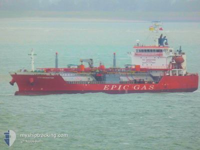
EPIC MANHATTAN
Lpg Tanker
Current Trip
PA MNQ
| Time Travelled | 1 day |
|---|---|
| Remaining Time | --- |
| Distance Travelled | 411.38 nm |
| Remaining Distance | --- |
| AVG Speed | 14.2 Noeuds |
| MAX Speed | 15.5 Noeuds |
| AVG Wind | 15.8 knots |
| MAX Wind | 19.1 knots |
| MIN Temp | 27.2°C / 80.96°F |
| MAX Temp | 28.5°C / 83.3°F |
| Tirant d eau | 7.2 m |
| Position reçue | 1 d depuis |
Current Position
| Longitude | -79.81548° |
|---|---|
| Latitude | 9.39190° |
| Etat | Moored |
| Vitesse | |
| Parcours | 343° |
| Zone | Caribbean Sea |
| Station | T-AIS |
| Position reçue | 1 d depuis |
Info
Information
The current position of EPIC MANHATTAN is in Caribbean Sea with coordinates 9.39190° / -79.81548° as reported on 2024-04-24 04:13 by AIS to our vessel tracker app. The vessel's current speed is 0 Noeuds
The vessel EPIC MANHATTAN (IMO: 9392236, MMSI: 565699000) is a Lpg Tanker that was built in 2007 ( 17 Age ). It's sailing under the flag of [SG] Singapore.
In this page you can find informations about the vessels current position, last detected port calls, and current voyage information. If the vessels is not in coverage by AIS you will find the latest position.
The current position of EPIC MANHATTAN is detected by our AIS receivers and we are not responsible for the reliability of the data. The last position was recorded while the vessel was in Coverage by the Ais receivers of our vessel tracking app.
The current draught of EPIC MANHATTAN as reported by AIS is 7.2 meters
Weather
| Temperature | 27.6°C / 81.68°F |
|---|---|
| Wind Speed | 19 knots |
| Direction | 32° NNE |
| Pressure | 1014.3 hPa |
| Humidity | 74.3 % |
| Cloud Coverage | 3 % |
Featured Company
Last Port Calls
| Port | Arrival | Departure | Time In Port |
|---|---|---|---|
| 2024-04-22 12:06 | 2024-04-24 07:18 | 1 d | |
| 2024-04-17 12:34 | 2024-04-18 15:16 | 1 d | |
| 2024-04-12 09:49 | 2024-04-12 13:40 | 3 h | |
| 2024-04-06 18:24 | 2024-04-08 01:44 | 1 d | |
| 2024-04-05 23:32 | 2024-04-06 17:00 | 17 h | |
| 2024-03-27 16:53 | 2024-03-29 02:41 | 1 d | |
| 2024-03-19 08:03 | 2024-03-21 01:34 | 1 d | |
| 2024-03-13 12:38 | 2024-03-15 06:16 | 1 d | |
| 2024-02-26 17:57 | 2024-02-28 05:40 | 1 d | |
| 2024-02-22 22:22 | 2024-02-25 03:33 | 2 d |
Most Visited Ports (Last year)
| Port | Arrivals | |
|---|---|---|
| 25 | ||
| 19 | ||
| 19 | ||
| 3 | ||
| 1 |
Last Trips
| Origin | Departure | Destination | Arrival | Distance | |
|---|---|---|---|---|---|
| 2024-04-18 09:16 | 2024-04-22 07:06 | 796.15 nm | |||
| 2024-04-12 08:40 | 2024-04-17 06:34 | 1121.31 nm | |||
| 2024-04-07 20:44 | 2024-04-12 04:49 | 1414.78 nm | |||
| 2024-04-06 12:00 | 2024-04-06 13:24 | 11.80 nm | |||
| 2024-03-28 20:41 | 2024-04-05 18:32 | 817.90 nm | |||
| 2024-03-20 20:34 | 2024-03-27 10:53 | 1136.81 nm | |||
| 2024-03-15 01:16 | 2024-03-19 03:03 | 1370.13 nm | |||
| 2024-02-27 23:40 | 2024-03-13 07:38 | 1788.24 nm | |||
| 2024-02-24 21:33 | 2024-02-26 11:57 | 114.58 nm | |||
| 2024-02-19 18:57 | 2024-02-22 16:22 | 957.51 nm |
Events
| Heure | Evenement | Détails | Position/ Destination | Info |
|---|---|---|---|---|
| 2024-04-24 07:18 | Démarrage | 0.34 nm, North of LAS MINAS |
9.39644 / -79.81664
PA MNQ
|
Vitesse: 4.6 kn Parcours: 328° |
| 2024-04-24 07:18 | PORT DE DEPART |
|
9.39644 / -79.81664
PA MNQ
|
Vitesse: 1.6 kn Parcours: 351° |
| 2024-04-24 04:22 | Etat Changé | Default Moored |
9.39189 / -79.81548
[PA] LAS MINAS
|
Vitesse: Parcours: 343° |
| 2024-04-24 04:13 | Etat Changé | Moored Default |
9.39190 / -79.81548
[PA] LAS MINAS
|
Vitesse: Parcours: 343° |
| 2024-04-24 04:13 | Hors de la zone couverte |
9.39190 / -79.81548
Caribbean Sea
[PA] LAS MINAS
|
Vitesse: Parcours: 236° |
|
| 2024-04-24 04:04 | Etat Changé | Default Moored |
9.39190 / -79.81548
[PA] LAS MINAS
|
Vitesse: Parcours: 343° |
| 2024-04-24 03:58 | Etat Changé | Moored Default |
9.39191 / -79.81546
[PA] LAS MINAS
|
Vitesse: Parcours: -1° |
| 2024-04-24 03:43 | Dans la zone couverte |
9.39191 / -79.81546
Caribbean Sea
[PA] LAS MINAS
|
Vitesse: Parcours: 236° |
|
| 2024-04-24 01:55 | Etat Changé | Default Moored |
9.39167 / -79.81500
[PA] LAS MINAS
|
Vitesse: Parcours: 343° |
| 2024-04-24 01:43 | Hors de la zone couverte |
9.39190 / -79.81546
Caribbean Sea
[PA] LAS MINAS
|
Vitesse: Parcours: 236° |