
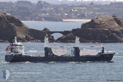
EENDRACHT
General Cargo
Current Trip
| Time Travelled | 6 days |
|---|---|
| Remaining Time | 3 h, 16 mins |
| Distance Travelled | 2216.54 nm |
| Remaining Distance | 199.63 nm |
| AVG Speed | 14.1 Noeuds |
| MAX Speed | 17.4 Noeuds |
| AVG Wind | 12.5 knots |
| MAX Wind | 27 knots |
| MIN Temp | 7.8°C / 46.04°F |
| MAX Temp | 17.9°C / 64.22°F |
| Tirant d eau | 5.2 m |
| Position reçue | Maintenant |
Current Position
| Longitude | -2.41779° |
|---|---|
| Latitude | 47.13719° |
| Etat | Under way using engine |
| Vitesse | |
| Parcours | 266° |
| Zone | Bay of Biscay |
| Station | T-AIS |
| Position reçue | Maintenant |
Info
Information
The current position of EENDRACHT is in Bay of Biscay with coordinates 47.13719° / -2.41779° as reported on 2024-04-25 04:01 by AIS to our vessel tracker app. The vessel's current speed is 0 Noeuds and is heading at the port of MONTOIR. The estimated time of arrival as calculated by MyShipTracking vessel tracking app is 2024-04-25 07:18 LT
The vessel EENDRACHT (IMO: 9512783, MMSI: 244620052) is a General Cargo that was built in 2009 ( 15 Age ). It's sailing under the flag of [NL] Netherlands.
In this page you can find informations about the vessels current position, last detected port calls, and current voyage information. If the vessels is not in coverage by AIS you will find the latest position.
The current position of EENDRACHT is detected by our AIS receivers and we are not responsible for the reliability of the data. The last position was recorded while the vessel was in Coverage by the Ais receivers of our vessel tracking app.
The current draught of EENDRACHT as reported by AIS is 5.2 meters
Weather
| Temperature | 7.7°C / 45.86°F |
|---|---|
| Wind Speed | 7 knots |
| Direction | 43° NE |
| Pressure | 1010.2 hPa |
| Humidity | 84.7 % |
| Cloud Coverage | 70 % |
Featured Company
Last Port Calls
| Port | Arrival | Departure | Time In Port |
|---|---|---|---|
| 2024-04-14 17:35 | 2024-04-18 11:14 | 3 d | |
| 2024-04-11 14:39 | 2024-04-12 11:30 | 20 h | |
| 2024-04-08 14:17 | 2024-04-08 18:29 | 4 h | |
| 2024-04-04 07:35 | 2024-04-04 18:10 | 10 h | |
| 2024-04-01 09:49 | 2024-04-01 20:55 | 11 h | |
| 2024-03-11 11:34 | 2024-03-12 21:51 | 1 d | |
| 2024-03-08 14:05 | 2024-03-09 13:47 | 23 h | |
| 2024-03-06 14:29 | 2024-03-07 02:16 | 11 h | |
| 2024-03-05 10:11 | 2024-03-05 16:45 | 6 h | |
| 2024-02-29 14:27 | 2024-03-01 21:49 | 1 d |
Most Visited Ports (Last year)
| Port | Arrivals | |
|---|---|---|
| 6 | ||
| 4 | ||
| 2 | ||
| 2 | ||
| 2 | ||
| 2 |
Last Trips
| Origin | Departure | Destination | Arrival | Distance | |
|---|---|---|---|---|---|
| 2024-04-12 14:30 | 2024-04-14 19:35 | 820.22 nm | |||
| 2024-04-08 21:29 | 2024-04-11 17:39 | 868.69 nm | |||
| 2024-04-04 20:10 | 2024-04-08 17:17 | 1085.20 nm | |||
| 2024-04-01 22:55 | 2024-04-04 09:35 | 895.26 nm | |||
| 2024-03-12 22:51 | 2024-04-01 11:49 | 3816.79 nm | |||
| 2024-03-09 14:47 | 2024-03-11 12:34 | 581.40 nm | |||
| 2024-03-07 03:16 | 2024-03-08 15:05 | 126.07 nm | |||
| 2024-03-05 17:45 | 2024-03-06 15:29 | 116.22 nm | |||
| 2024-03-01 22:49 | 2024-03-05 11:11 | 302.61 nm | |||
| 2024-02-26 20:24 | 2024-02-29 15:27 | 294.43 nm |
Events
| Heure | Evenement | Détails | Position/ Destination | Info |
|---|---|---|---|---|
| 2024-04-24 17:05 | Arret | 8.38 nm, South of LE POULIGUEN |
47.13728 / -2.41891
MONTOIR
|
Vitesse: 0.1 kn Parcours: 288° |
| 2024-04-24 16:04 | Tirant d'eau modifié | 5.2 5 |
46.99444 / -2.65786
MONTOIR
|
Vitesse: 15.6 kn Parcours: 50.6° |
| 2024-04-24 14:47 | Changement de zone | French part of the Bay of Biscay Spanish part of the North Atlantic Ocean |
46.79816 / -3.03691
Bay of Biscay
|
Vitesse: 15.4 kn Parcours: 52.2° |
| 2024-04-24 14:44 | Etat Changé | Under way using engine Default |
46.79217 / -3.04813
MONTOIR
|
Vitesse: 15.2 kn Parcours: 59° |
| 2024-04-24 14:44 | Dans la zone couverte |
46.79816 / -3.03691
Bay of Biscay
|
Vitesse: 15.4 kn Parcours: 52.2° |
|
| 2024-04-23 19:21 | Hors de la zone couverte |
43.93865 / -8.67258
North Atlantic Ocean
MONTOIR
|
Vitesse: 14.4 kn Parcours: 53.6° |
|
| 2024-04-23 18:23 | Etat Changé | Under way using engine Default |
43.79558 / -8.93197
MONTOIR
|
Vitesse: 14.5 kn Parcours: 50° |
| 2024-04-23 18:06 | Etat Changé | Default Under way using engine |
43.75212 / -9.00465
MONTOIR
|
Vitesse: 14.6 kn Parcours: 51° |
| 2024-04-23 16:39 | Etat Changé | Under way using engine Default |
43.53091 / -9.39003
MONTOIR
|
Vitesse: 14.6 kn Parcours: 52° |
| 2024-04-23 16:39 | Dans la zone couverte |
43.53091 / -9.39003
North Atlantic Ocean
MONTOIR
|
Vitesse: 14.4 kn Parcours: 51.2° |