
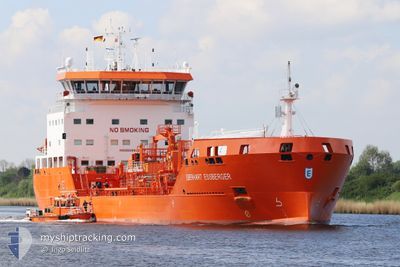
EBERHART ESSBERGER
Tanker
Current Trip
| Time Travelled | 2 h, 35 mins |
|---|---|
| Remaining Time | 8 h, 20 mins |
| Distance Travelled | 31.40 nm |
| Remaining Distance | 108.70 nm |
| AVG Speed | 13.2 Noeuds |
| MAX Speed | 14.4 Noeuds |
| AVG Wind | 16.4 knots |
| MAX Wind | 22.7 knots |
| MIN Temp | 11.8°C / 53.24°F |
| MAX Temp | 12.4°C / 54.32°F |
| Tirant d eau | 5.6 m |
| Position reçue | 1 m depuis |
Current Position
| Longitude | --- |
|---|---|
| Latitude | --- |
| Etat | Under way using engine |
| Vitesse | 12 Noeuds |
| Parcours | 105.1° |
| Zone | North Sea |
| Station | T-AIS |
| Position reçue | 1 m depuis |
Info
Information
The current position of EBERHART ESSBERGER is in North Sea with coordinates 51.46219° / 1.42266° as reported on 2025-12-09 06:10 by AIS to our vessel tracker app. The vessel's current speed is 12 Noeuds and is heading at the port of GENT. The estimated time of arrival as calculated by MyShipTracking vessel tracking app is 2025-12-09 15:31 LT
The vessel EBERHART ESSBERGER (IMO: 9939802, MMSI: 255892000) is a Tanker It's sailing under the flag of [PT] Portugal.
In this page you can find informations about the vessels current position, last detected port calls, and current voyage information. If the vessels is not in coverage by AIS you will find the latest position.
The current position of EBERHART ESSBERGER is detected by our AIS receivers and we are not responsible for the reliability of the data. The last position was recorded while the vessel was in Coverage by the Ais receivers of our vessel tracking app.
The current draught of EBERHART ESSBERGER as reported by AIS is 5.6 meters
Weather
| Temperature | 11.9°C / 53.42°F |
|---|---|
| Wind Speed | 23 knots |
| Direction | 198° SSW |
| Pressure | 1007.5 hPa |
| Humidity | 87.9 % |
| Cloud Coverage | 100 % |
Featured Company
Last Port Calls
| Port | Arrival | Departure | Time In Port |
|---|---|---|---|
| 2025-12-06 00:53 | 2025-12-09 03:36 | 3 d | |
| 2025-12-02 23:45 | 2025-12-04 06:26 | 1 d | |
| 2025-11-27 01:47 | 2025-12-01 09:41 | 4 d | |
| 2025-11-25 12:26 | 2025-11-26 12:43 | 1 d | |
| 2025-11-18 23:56 | 2025-11-20 00:33 | 1 d | |
| 2025-11-18 22:45 | 2025-11-18 23:15 | 30 m | |
| 2025-11-10 11:52 | 2025-11-11 03:17 | 15 h | |
| 2025-11-05 21:11 | 2025-11-07 17:04 | 1 d | |
| 2025-11-01 22:49 | 2025-11-03 06:31 | 1 d | |
| 2025-10-26 14:30 | 2025-10-27 22:21 | 1 d |
Most Visited Ports (Last year)
| Port | Arrivals | |
|---|---|---|
| 11 | ||
| 10 | ||
| 7 | ||
| 4 | ||
| 4 | ||
| 4 |
Last Trips
| Origin | Departure | Destination | Arrival | Distance | |
|---|---|---|---|---|---|
| 2025-12-04 06:26 | 2025-12-06 00:53 | 167.12 nm | |||
| 2025-12-01 09:41 | 2025-12-02 23:45 | 274.69 nm | |||
| 2025-11-26 12:43 | 2025-11-27 01:47 | 157.19 nm | |||
| 2025-11-20 00:33 | 2025-11-25 12:26 | 415.51 nm | |||
| 2025-11-18 23:15 | 2025-11-18 23:56 | 5.74 nm | |||
| 2025-11-11 03:17 | 2025-11-18 22:45 | 980.24 nm | |||
| 2025-11-07 17:04 | 2025-11-10 11:52 | 726.78 nm | |||
| 2025-11-03 06:31 | 2025-11-05 21:11 | 190.17 nm | |||
| 2025-10-27 22:21 | 2025-11-01 22:49 | 172.80 nm | |||
| 2025-10-23 23:27 | 2025-10-26 14:30 | 185.64 nm |
Events
| Heure | Evenement | Détails | Position/ Destination | Info |
|---|---|---|---|---|
| 2025-12-09 04:33 | Changement d'ETA | 2025/12/09 18:00 2025/12/09 12:00 |
51.48749 / .89205
BE GNE
|
Vitesse: 13.6 kn Parcours: 107.4° |
| 2025-12-09 03:36 | PORT DE DEPART |
|
51.50239 / .56736
BE GNE
|
Vitesse: 8.4 kn Parcours: 97° |
| 2025-12-09 03:34 | Etat Changé | Under way using engine Moored |
51.50404 / .55887
[GB] CANVEY ISLAND
|
Vitesse: 6 kn Parcours: 110° |
| 2025-12-09 03:30 | Démarrage |
51.50630 / .55407
[GB] CANVEY ISLAND
|
Vitesse: 3.7 kn Parcours: 165° |
|
| 2025-12-09 02:48 | Tirant d'eau modifié | 5.6 6.2 |
51.50877 / .55525
[GB] CANVEY ISLAND
|
Vitesse: Parcours: 283° |
| 2025-12-09 02:48 | Changement de destination | BE GNE GB LON |
51.50877 / .55525
[GB] CANVEY ISLAND
|
Vitesse: Parcours: 283° |
| 2025-12-09 02:41 | Changement d'ETA | 2025/12/09 12:00 2025/12/04 13:00 |
51.50877 / .55526
[GB] CANVEY ISLAND
|
Vitesse: Parcours: 283° |
| 2025-12-09 00:22 | Etat Changé | Moored Default |
51.50879 / .55525
[GB] CANVEY ISLAND
|
Vitesse: Parcours: 283° |
| 2025-12-09 00:19 | Etat Changé | Default Moored |
51.50880 / .55525
[GB] CANVEY ISLAND
|
Vitesse: Parcours: 283° |
| 2025-12-08 06:22 | Etat Changé | Moored Default |
51.50879 / .55526
[GB] CANVEY ISLAND
|
Vitesse: Parcours: 283° |