
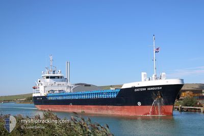
EASTERN VANQUISH
General Cargo
Current Trip
| Time Travelled | 2 days |
|---|---|
| Remaining Time | --- |
| Distance Travelled | 395.60 nm |
| Remaining Distance | --- |
| AVG Speed | 10.2 Noeuds |
| MAX Speed | 11.5 Noeuds |
| AVG Wind | 11.4 knots |
| MAX Wind | 26 knots |
| MIN Temp | 12.4°C / 54.32°F |
| MAX Temp | 23.5°C / 74.3°F |
| Tirant d eau | 3.6 m |
| Position reçue | Maintenant |
Current Position
| Longitude | 29.44985° |
|---|---|
| Latitude | 40.76176° |
| Etat | Under way using engine |
| Vitesse | 0.4 Noeuds |
| Parcours | 346° |
| Zone | Sea of Marmara |
| Station | T-AIS |
| Position reçue | Maintenant |
Info
Information
The current position of EASTERN VANQUISH is in Sea of Marmara with coordinates 40.76176° / 29.44985° as reported on 2024-04-19 04:38 by AIS to our vessel tracker app. The vessel's current speed is 0.4 Noeuds
The vessel EASTERN VANQUISH (IMO: 9411836, MMSI: 235113663) is a General Cargo that was built in 2012 ( 12 Age ). It's sailing under the flag of [GB] United Kingdom.
In this page you can find informations about the vessels current position, last detected port calls, and current voyage information. If the vessels is not in coverage by AIS you will find the latest position.
The current position of EASTERN VANQUISH is detected by our AIS receivers and we are not responsible for the reliability of the data. The last position was recorded while the vessel was in Coverage by the Ais receivers of our vessel tracking app.
The current draught of EASTERN VANQUISH as reported by AIS is 3.6 meters
Weather
| Temperature | 12.5°C / 54.5°F |
|---|---|
| Wind Speed | 2 knots |
| Direction | 77° ENE |
| Pressure | 1011.7 hPa |
| Humidity | 90.7 % |
| Cloud Coverage | 99 % |
Featured Company
Last Port Calls
| Port | Arrival | Departure | Time In Port |
|---|---|---|---|
| 2024-04-13 05:14 | 2024-04-16 11:16 | 3 d | |
| 2024-04-09 10:58 | 2024-04-10 17:36 | 1 d | |
| 2024-04-03 08:11 | 2024-04-05 11:21 | 2 d | |
| 2024-03-28 10:29 | 2024-03-29 21:20 | 1 d | |
| 2024-03-25 14:36 | 2024-03-27 21:03 | 2 d | |
| 2024-03-07 17:39 | 2024-03-11 20:48 | 4 d | |
| 2024-03-05 11:39 | 2024-03-06 15:43 | 1 d | |
| 2024-02-28 02:46 | 2024-02-28 23:47 | 21 h | |
| 2024-02-16 10:26 | 2024-02-19 18:14 | 3 d | |
| 2024-02-12 22:35 | 2024-02-14 15:10 | 1 d |
Most Visited Ports (Last year)
| Port | Arrivals | |
|---|---|---|
| 7 | ||
| 3 | ||
| 3 | ||
| 3 | ||
| 3 | ||
| 3 |
Last Trips
| Origin | Departure | Destination | Arrival | Distance | |
|---|---|---|---|---|---|
| 2024-04-10 19:36 | 2024-04-13 08:14 | 542.99 nm | |||
| 2024-04-05 13:21 | 2024-04-09 12:58 | 262.04 nm | |||
| 2024-03-29 23:20 | 2024-04-03 10:11 | 1038.56 nm | |||
| 2024-03-27 23:03 | 2024-03-28 12:29 | 130.73 nm | |||
| 2024-03-11 21:48 | 2024-03-25 16:36 | 2599.65 nm | |||
| 2024-03-06 16:43 | 2024-03-07 18:39 | 276.39 nm | |||
| 2024-02-29 00:47 | 2024-03-05 12:39 | 1147.90 nm | |||
| 2024-02-19 18:14 | 2024-02-28 03:46 | 465.82 nm | |||
| 2024-02-14 16:10 | 2024-02-16 10:26 | 427.95 nm | |||
| 2024-02-12 18:29 | 2024-02-12 23:35 | 33.40 nm |
Events
| Heure | Evenement | Détails | Position/ Destination | Info |
|---|---|---|---|---|
| 2024-04-19 04:28 | Etat Changé | Under way using engine At anchor |
40.76193 / 29.45015
TR DIL
|
Vitesse: 0.1 kn Parcours: 100° |
| 2024-04-18 05:37 | Etat Changé | At anchor Under way using engine |
40.76136 / 29.44894
TR DIL
|
Vitesse: 0.4 kn Parcours: 31° |
| 2024-04-18 05:32 | Arret | 1.18 nm, East of ESKIHISAR |
40.76187 / 29.44944
TR DIL
|
Vitesse: 0.2 kn Parcours: 4° |
| 2024-04-17 20:00 | Changement d'ETA | 2024/04/18 09:00 2024/04/18 06:00 |
40.62225 / 27.34412
TR DIL
|
Vitesse: 10.3 kn Parcours: 66.6° |
| 2024-04-17 19:45 | Etat Changé | Under way using engine Default |
40.60483 / 27.29191
TR DIL
|
Vitesse: 10.3 kn Parcours: 66° |
| 2024-04-17 19:35 | Etat Changé | Default Under way using engine |
40.59215 / 27.25441
TR DIL
|
Vitesse: 10.2 kn Parcours: 65.9° |
| 2024-04-17 19:32 | Etat Changé | Under way using engine Default |
40.58884 / 27.24473
TR DIL
|
Vitesse: 10.1 kn Parcours: 64° |
| 2024-04-17 19:32 | Dans la zone couverte |
40.58884 / 27.24473
Sea of Marmara
TR DIL
|
Vitesse: 10.2 kn Parcours: 65.9° |
|
| 2024-04-17 15:58 | Etat Changé | Default Under way using engine |
40.27851 / 26.56370
TR DIL
|
Vitesse: 11.2 kn Parcours: 47.2° |
| 2024-04-17 15:56 | Hors de la zone couverte |
40.27596 / 26.56010
Sea of Marmara
TR DIL
|
Vitesse: 11.2 kn Parcours: 47.2° |