
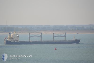
DONG FANG WEI YE
Bulk Carrier
Current Trip
| Time Travelled | 14 days |
|---|---|
| Remaining Time | --- |
| Distance Travelled | 2324.81 nm |
| Remaining Distance | --- |
| AVG Speed | 10.3 Noeuds |
| MAX Speed | 11.5 Noeuds |
| AVG Wind | 5.7 knots |
| MAX Wind | 19.9 knots |
| MIN Temp | 3.9°C / 39.02°F |
| MAX Temp | 29.2°C / 84.56°F |
| Tirant d eau | 9 m |
| Position reçue | 19 h, 26 m depuis |
Current Position
| Longitude | 107.40785° |
|---|---|
| Latitude | 20.60469° |
| Etat | Under way using engine |
| Vitesse | 10.7 Noeuds |
| Parcours | 104.4° |
| Zone | South China Sea |
| Station | T-AIS |
| Position reçue | 19 h, 26 m depuis |
Info
Information
The current position of DONG FANG WEI YE is in South China Sea with coordinates 20.60469° / 107.40785° as reported on 2024-04-24 11:39 by AIS to our vessel tracker app. The vessel's current speed is 10.7 Noeuds and is heading at the port of CAM PHA. The estimated time of arrival as calculated by MyShipTracking vessel tracking app is 2024-04-19 17:00 LT
The vessel DONG FANG WEI YE (IMO: 9584798, MMSI: 413229350) is a Bulk Carrier that was built in 2010 ( 14 Age ). It's sailing under the flag of [CN] China.
In this page you can find informations about the vessels current position, last detected port calls, and current voyage information. If the vessels is not in coverage by AIS you will find the latest position.
The current position of DONG FANG WEI YE is detected by our AIS receivers and we are not responsible for the reliability of the data. The last position was recorded while the vessel was in Coverage by the Ais receivers of our vessel tracking app.
The current draught of DONG FANG WEI YE as reported by AIS is 9 meters
Weather
| Temperature | 27.7°C / 81.86°F |
|---|---|
| Wind Speed | 20 knots |
| Direction | 170° S |
| Pressure | 1003.2 hPa |
| Humidity | 75.4 % |
| Cloud Coverage | --- |
Featured Company
Last Port Calls
| Port | Arrival | Departure | Time In Port |
|---|---|---|---|
| 2024-04-05 03:52 | 2024-04-10 20:55 | 5 d | |
| 2024-04-03 05:31 | 2024-04-04 02:04 | 20 h | |
| 2024-02-14 00:59 | 2024-02-16 02:53 | 2 d | |
| 2024-02-02 02:38 |
Most Visited Ports (Last year)
| Port | Arrivals | |
|---|---|---|
| 11 | ||
| 3 | ||
| 2 | ||
| 2 | ||
| 2 | ||
| 2 |
Last Trips
| Origin | Departure | Destination | Arrival | Distance | |
|---|---|---|---|---|---|
| 2024-04-04 12:04 | 2024-04-05 13:52 | 3.82 nm | |||
| 2024-02-16 12:53 | 2024-04-03 15:31 | 1560.83 nm | |||
| 2024-02-02 10:38 | 2024-02-14 10:59 | 1210.72 nm |
Events
| Heure | Evenement | Détails | Position/ Destination | Info |
|---|---|---|---|---|
| 2024-04-24 11:41 | Etat Changé | Default Under way using engine |
20.60312 / 107.41466
VN CPH
|
Vitesse: 10.7 kn Parcours: 104.4° |
| 2024-04-24 11:39 | Etat Changé | Under way using engine Default |
20.60469 / 107.40785
VN CPH
|
Vitesse: 10.9 kn Parcours: 107° |
| 2024-04-24 11:39 | Hors de la zone couverte |
20.60469 / 107.40785
South China Sea
|
Vitesse: 10.7 kn Parcours: 104.4° |
|
| 2024-04-24 11:36 | Etat Changé | Default Under way using engine |
20.60649 / 107.40114
VN CPH
|
Vitesse: 10.9 kn Parcours: 106.5° |
| 2024-04-24 11:31 | Etat Changé | Under way using engine Default |
20.61137 / 107.38411
VN CPH
|
Vitesse: 10.9 kn Parcours: 107° |
| 2024-04-24 11:29 | Etat Changé | Default Under way using engine |
20.61334 / 107.37717
VN CPH
|
Vitesse: 10.9 kn Parcours: 106° |
| 2024-04-24 11:13 | Etat Changé | Under way using engine Default |
20.62598 / 107.32765
VN CPH
|
Vitesse: 11.2 kn Parcours: 144° |
| 2024-04-24 10:32 | Etat Changé | Default Under way using engine |
20.72246 / 107.24148
VN CPH
|
Vitesse: 10.9 kn Parcours: 210.5° |
| 2024-04-24 10:00 | Etat Changé | Under way using engine Default |
20.79682 / 107.27379
VN CPH
|
Vitesse: 7.3 kn Parcours: 208° |
| 2024-04-24 09:17 | Etat Changé | Default Under way using engine |
20.87568 / 107.28609
VN CPH
|
Vitesse: 9.3 kn Parcours: 139.6° |