
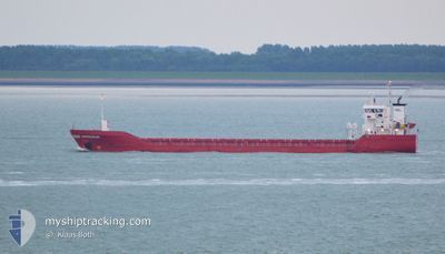
DINTELDIJK
General Cargo
Current Trip
| Time Travelled | 16 h, 36 mins |
|---|---|
| Remaining Time | 8 h, 27 mins |
| Distance Travelled | 176.30 nm |
| Remaining Distance | 89.76 nm |
| AVG Speed | 10.5 Noeuds |
| MAX Speed | 14.8 Noeuds |
| AVG Wind | 9.1 knots |
| MAX Wind | 13.2 knots |
| MIN Temp | 6°C / 42.8°F |
| MAX Temp | 9°C / 48.2°F |
| Tirant d eau | 3.8 m |
| Position reçue | 1 m depuis |
Current Position
| Longitude | -4.94413° |
|---|---|
| Latitude | 51.48820° |
| Etat | Under way using engine |
| Vitesse | 10.9 Noeuds |
| Parcours | 99.2° |
| Zone | Celtic Sea |
| Station | T-AIS |
| Position reçue | 1 m depuis |
Info
Information
The current position of DINTELDIJK is in Celtic Sea with coordinates 51.48820° / -4.94413° as reported on 2024-04-25 14:37 by AIS to our vessel tracker app. The vessel's current speed is 10.9 Noeuds and is heading at the port of AVONMOUTH. The estimated time of arrival as calculated by MyShipTracking vessel tracking app is 2024-04-25 23:05 LT
The vessel DINTELDIJK (IMO: 9346677, MMSI: 245044000) is a General Cargo that was built in 2007 ( 17 Age ). It's sailing under the flag of [NL] Netherlands.
In this page you can find informations about the vessels current position, last detected port calls, and current voyage information. If the vessels is not in coverage by AIS you will find the latest position.
The current position of DINTELDIJK is detected by our AIS receivers and we are not responsible for the reliability of the data. The last position was recorded while the vessel was in Coverage by the Ais receivers of our vessel tracking app.
The current draught of DINTELDIJK as reported by AIS is 3.8 meters
Weather
| Temperature | 9°C / 48.2°F |
|---|---|
| Wind Speed | 10 knots |
| Direction | 310° NW |
| Pressure | 1004.1 hPa |
| Humidity | 71.7 % |
| Cloud Coverage | 77 % |
Featured Company
Last Port Calls
| Port | Arrival | Departure | Time In Port |
|---|---|---|---|
| 2024-04-22 22:46 | 2024-04-24 22:02 | 1 d | |
| 2024-04-15 22:16 | 2024-04-18 03:36 | 2 d | |
| 2024-04-14 01:25 | 2024-04-15 06:56 | 1 d | |
| 2024-04-08 11:03 | 2024-04-10 12:55 | 2 d | |
| 2024-04-01 18:41 | 2024-04-01 22:21 | 3 h | |
| 2024-03-22 10:56 | 2024-03-23 11:34 | 1 d | |
| 2024-03-10 09:42 | 2024-03-20 14:21 | 10 d | |
| 2024-03-01 20:42 | 2024-03-02 00:39 | 3 h | |
| 2024-02-15 02:05 | |||
| 2024-02-07 19:25 | 2024-02-07 19:42 | 17 m |
Last Trips
| Origin | Departure | Destination | Arrival | Distance | |
|---|---|---|---|---|---|
| 2024-04-18 05:36 | 2024-04-22 23:46 | 669.26 nm | |||
| 2024-04-15 07:56 | 2024-04-16 00:16 | 168.46 nm | |||
| 2024-04-10 13:55 | 2024-04-14 02:25 | 717.05 nm | |||
| 2024-04-02 00:21 | 2024-04-08 12:03 | 1433.17 nm | |||
| 2024-03-23 14:34 | 2024-04-01 20:41 | 2101.38 nm | |||
| 2024-03-20 16:21 | 2024-03-22 13:56 | 464.53 nm | |||
| 2024-03-02 01:39 | 2024-03-10 11:42 | 1816.30 nm | |||
| 2024-02-15 03:05 | 2024-03-01 21:42 | 2510.54 nm | |||
| 2024-02-07 20:22 | 2024-02-07 20:25 | 0.04 nm | |||
| 2024-02-02 19:41 | 2024-02-02 20:05 | 0.70 nm |
Events
| Heure | Evenement | Détails | Position/ Destination | Info |
|---|---|---|---|---|
| 2024-04-25 12:28 | Detecté en mer | United Kingdom part of the Celtic Sea |
51.56919 / -5.56893
Celtic Sea
AVONMOUTH
|
Vitesse: 10 kn Parcours: 104° |
| 2024-04-25 12:26 | Etat Changé | Under way using engine Default |
51.57063 / -5.57766
AVONMOUTH
|
Vitesse: 10.2 kn Parcours: 105° |
| 2024-04-25 12:18 | Dans la zone couverte |
51.56919 / -5.56893
Celtic Sea
AVONMOUTH
|
Vitesse: 10 kn Parcours: 104° |
|
| 2024-04-25 07:49 | Etat Changé | Default Under way using engine |
52.11666 / -5.80167
AVONMOUTH
|
Vitesse: 8.7 kn Parcours: 189.6° |
| 2024-04-25 07:38 | Etat Changé | Under way using engine Default |
52.14421 / -5.79533
AVONMOUTH
|
Vitesse: 8 kn Parcours: 187° |
| 2024-04-25 07:38 | Hors de la zone couverte |
52.14421 / -5.79533
Irish Sea and St. George's Channel
AVONMOUTH
|
Vitesse: 8.7 kn Parcours: 189.6° |
|
| 2024-04-25 07:31 | Etat Changé | Default Under way using engine |
52.15833 / -5.79167
AVONMOUTH
|
Vitesse: 8.9 kn Parcours: 188.4° |
| 2024-04-25 07:20 | Etat Changé | Under way using engine Default |
52.18632 / -5.78606
AVONMOUTH
|
Vitesse: 9 kn Parcours: 187° |
| 2024-04-25 06:52 | Etat Changé | Default Under way using engine |
52.25667 / -5.76833
AVONMOUTH
|
Vitesse: 9.5 kn Parcours: 191.3° |
| 2024-04-25 06:39 | Etat Changé | Under way using engine Default |
52.29110 / -5.75833
AVONMOUTH
|
Vitesse: 9 kn Parcours: 190° |