
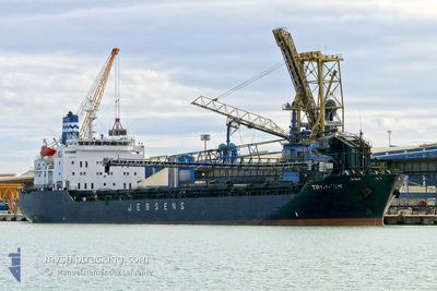
CSL TRIMNES
Self Discharging Bulk Carrier
Current Trip
| Time Travelled | 4 days |
|---|---|
| Remaining Time | 4 h, 57 mins |
| Distance Travelled | 725.46 nm |
| Remaining Distance | 63.54 nm |
| AVG Speed | 11.5 Noeuds |
| MAX Speed | 14.2 Noeuds |
| AVG Wind | 9.3 knots |
| MAX Wind | 21 knots |
| MIN Temp | 0.7°C / 33.26°F |
| MAX Temp | 7.5°C / 45.5°F |
| Tirant d eau | 8.8 m |
| Position reçue | 5 m depuis |
Current Position
| Longitude | 7.26683° |
|---|---|
| Latitude | 54.38733° |
| Etat | Under way using engine |
| Vitesse | 12.3 Noeuds |
| Parcours | 156° |
| Zone | North Sea |
| Station | T-AIS |
| Position reçue | 5 m depuis |
Info
Information
The current position of CSL TRIMNES is in North Sea with coordinates 54.38733° / 7.26683° as reported on 2024-04-25 07:13 by AIS to our vessel tracker app. The vessel's current speed is 12.3 Noeuds and is heading at the port of WILHELMSHAVEN. The estimated time of arrival as calculated by MyShipTracking vessel tracking app is 2024-04-25 12:16 LT
The vessel CSL TRIMNES (IMO: 8908583, MMSI: 215349000) is a Self Discharging Bulk Carrier that was built in 1990 ( 34 Age ). It's sailing under the flag of [MT] Malta.
In this page you can find informations about the vessels current position, last detected port calls, and current voyage information. If the vessels is not in coverage by AIS you will find the latest position.
The current position of CSL TRIMNES is detected by our AIS receivers and we are not responsible for the reliability of the data. The last position was recorded while the vessel was in Coverage by the Ais receivers of our vessel tracking app.
The current draught of CSL TRIMNES as reported by AIS is 8.8 meters
Weather
| Temperature | 5.4°C / 41.72°F |
|---|---|
| Wind Speed | 10 knots |
| Direction | --- N |
| Pressure | 1003.2 hPa |
| Humidity | 85.5 % |
| Cloud Coverage | 100 % |
Featured Company
Last Port Calls
| Port | Arrival | Departure | Time In Port |
|---|---|---|---|
| 2024-04-19 23:43 | 2024-04-21 07:04 | 1 d | |
| 2024-04-17 01:31 | 2024-04-18 00:52 | 23 h | |
| 2024-04-15 11:12 | 2024-04-16 10:03 | 22 h | |
| 2024-04-12 09:41 | 2024-04-13 10:06 | 1 d | |
| 2024-04-09 08:58 | 2024-04-10 05:17 | 20 h | |
| 2024-04-06 16:56 | 2024-04-07 08:28 | 15 h | |
| 2024-04-03 19:43 | 2024-04-04 16:29 | 20 h | |
| 2024-03-31 22:44 | 2024-04-01 16:53 | 18 h | |
| 2024-03-29 02:58 | 2024-03-30 00:07 | 21 h | |
| 2024-03-22 15:20 | 2024-03-28 01:25 | 5 d |
Last Trips
| Origin | Departure | Destination | Arrival | Distance | |
|---|---|---|---|---|---|
| 2024-04-18 02:52 | 2024-04-20 01:43 | 504.69 nm | |||
| 2024-04-16 12:03 | 2024-04-17 03:31 | 188.80 nm | |||
| 2024-04-13 12:06 | 2024-04-15 13:12 | 464.62 nm | |||
| 2024-04-10 07:17 | 2024-04-12 11:41 | 456.63 nm | |||
| 2024-04-07 10:28 | 2024-04-09 10:58 | 465.62 nm | |||
| 2024-04-04 18:29 | 2024-04-06 18:56 | 456.59 nm | |||
| 2024-04-01 18:53 | 2024-04-03 21:43 | 465.09 nm | |||
| 2024-03-30 01:07 | 2024-04-01 00:44 | 456.26 nm | |||
| 2024-03-28 02:25 | 2024-03-29 03:58 | 144.25 nm | |||
| 2024-03-20 13:15 | 2024-03-22 16:20 | 465.74 nm |
Events
| Heure | Evenement | Détails | Position/ Destination | Info |
|---|---|---|---|---|
| 2024-04-25 06:05 | Tirant d'eau modifié | 8.8 8.7 |
54.59929 / 7.10148
WILHELMSHAVEN
|
Vitesse: 12.1 kn Parcours: 157° |
| 2024-04-25 05:48 | Detecté en mer | German part of the North Sea |
54.65066 / 7.06267
North Sea
WILHELMSHAVEN
|
Vitesse: 11.9 kn Parcours: 156° |
| 2024-04-25 05:48 | Etat Changé | Under way using engine Default |
54.65066 / 7.06267
WILHELMSHAVEN
|
Vitesse: 11.7 kn Parcours: 155° |
| 2024-04-25 05:48 | Dans la zone couverte |
54.65066 / 7.06267
North Sea
WILHELMSHAVEN
|
Vitesse: 11.9 kn Parcours: 156° |
|
| 2024-04-24 15:57 | Etat Changé | Default Under way using engine |
57.22200 / 5.58733
WILHELMSHAVEN
|
Vitesse: 12 kn Parcours: 167° |
| 2024-04-24 15:41 | Hors de la zone couverte |
57.27267 / 5.56583
North Sea
WILHELMSHAVEN
|
Vitesse: 12 kn Parcours: 167° |
|
| 2024-04-24 03:47 | Démarrage | 2.47 nm, North of JELSA |
59.37400 / 6.03483
WILHELMSHAVEN
|
Vitesse: 3.3 kn Parcours: 223° |
| 2024-04-24 03:31 | Etat Changé | Under way using engine Moored |
59.37300 / 6.04333
WILHELMSHAVEN
|
Vitesse: 0.1 kn Parcours: 359° |
| 2024-04-23 18:56 | Tirant d'eau modifié | 8.7 6.2 |
59.37267 / 6.04367
WILHELMSHAVEN
|
Vitesse: Parcours: 4° |
| 2024-04-23 18:56 | Changement de destination | WILHELMSHAVEN JELSA |
59.37267 / 6.04367
WILHELMSHAVEN
|
Vitesse: Parcours: 4° |