
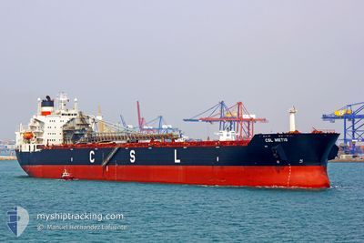
CSL METIS
Self Discharging Bulk Carrier
Current Trip
| Time Travelled | 23 days |
|---|---|
| Remaining Time | --- |
| Distance Travelled | 3991.11 nm |
| Remaining Distance | --- |
| AVG Speed | 11.8 Noeuds |
| MAX Speed | 16.5 Noeuds |
| AVG Wind | 15.4 knots |
| MAX Wind | 28.5 knots |
| MIN Temp | 0.8°C / 33.44°F |
| MAX Temp | 26.6°C / 79.88°F |
| Tirant d eau | 12.9 m |
| Position reçue | 23 d depuis |
Current Position
| Longitude | -76.18062° |
|---|---|
| Latitude | 36.99160° |
| Etat | Under way using engine |
| Vitesse | 10.9 Noeuds |
| Parcours | 107.7° |
| Zone | North Atlantic Ocean |
| Station | T-AIS |
| Position reçue | 23 d depuis |
Info
Information
The current position of CSL METIS is in North Atlantic Ocean with coordinates 36.99160° / -76.18062° as reported on 2024-03-27 05:42 by AIS to our vessel tracker app. The vessel's current speed is 10.9 Noeuds and is heading at the port of PASCAGOULA.
The vessel CSL METIS (IMO: 7926162, MMSI: 308976000) is a Self Discharging Bulk Carrier that was built in 1981 ( 43 Age ). It's sailing under the flag of [BS] Bahamas.
In this page you can find informations about the vessels current position, last detected port calls, and current voyage information. If the vessels is not in coverage by AIS you will find the latest position.
The current position of CSL METIS is detected by our AIS receivers and we are not responsible for the reliability of the data. The last position was recorded while the vessel was in Coverage by the Ais receivers of our vessel tracking app.
The current draught of CSL METIS as reported by AIS is 12.9 meters
Weather
| Temperature | 1.9°C / 35.42°F |
|---|---|
| Wind Speed | 20 knots |
| Direction | 334° NNW |
| Pressure | 1018.3 hPa |
| Humidity | 70.9 % |
| Cloud Coverage | 3 % |
Featured Company
Last Port Calls
| Port | Arrival | Departure | Time In Port |
|---|---|---|---|
| 2024-03-25 18:21 | 2024-03-27 05:18 | 1 d | |
| 2024-03-19 12:35 | 2024-03-20 12:50 | 1 d | |
| 2024-03-07 19:37 | 2024-03-09 05:21 | 1 d |
Most Visited Ports (Last year)
| Port | Arrivals | |
|---|---|---|
| 4 | ||
| 3 | ||
| 3 | ||
| 2 | ||
| 2 | ||
| 2 |
Last Trips
| Origin | Departure | Destination | Arrival | Distance | |
|---|---|---|---|---|---|
| 2024-03-20 08:50 | 2024-03-25 14:21 | 1487.91 nm | |||
| 2024-03-09 00:21 | 2024-03-19 08:35 | 2024.10 nm | |||
| 2024-01-28 09:01 | 2024-03-07 14:37 | 3254.97 nm |
Events
| Heure | Evenement | Détails | Position/ Destination | Info |
|---|---|---|---|---|
| 2024-04-16 19:08 | Arret | 11.42 nm, South East of PORT HAWKESBURY |
45.45927 / -61.20349
US NNS > US PGL
|
Vitesse: 0.3 kn Parcours: 290° |