
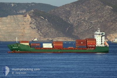
CONTSHIP JOY
General Cargo
Current Trip
| Time Travelled | 21 h, 20 mins |
|---|---|
| Remaining Time | --- |
| Distance Travelled | 237.11 nm |
| Remaining Distance | --- |
| AVG Speed | 11.3 Noeuds |
| MAX Speed | 12.2 Noeuds |
| AVG Wind | 5.4 knots |
| MAX Wind | 11.6 knots |
| MIN Temp | 15.3°C / 59.54°F |
| MAX Temp | 19.6°C / 67.28°F |
| Tirant d eau | 5.9 m |
| Position reçue | 1 m depuis |
Current Position
| Longitude | 35.49080° |
|---|---|
| Latitude | 33.81825° |
| Etat | Under way using engine |
| Vitesse | |
| Parcours | 197° |
| Zone | Mediterranean Sea - Eastern Basin |
| Station | T-AIS |
| Position reçue | 1 m depuis |
Info
Information
The current position of CONTSHIP JOY is in Mediterranean Sea - Eastern Basin with coordinates 33.81825° / 35.49080° as reported on 2024-04-20 01:10 by AIS to our vessel tracker app. The vessel's current speed is 0 Noeuds and is heading at the port of ASHDOD. The estimated time of arrival as calculated by MyShipTracking vessel tracking app is 2024-04-20 08:00 LT
The vessel CONTSHIP JOY (IMO: 9349174, MMSI: 636020064) is a General Cargo that was built in 2007 ( 17 Age ). It's sailing under the flag of [LR] Liberia.
In this page you can find informations about the vessels current position, last detected port calls, and current voyage information. If the vessels is not in coverage by AIS you will find the latest position.
The current position of CONTSHIP JOY is detected by our AIS receivers and we are not responsible for the reliability of the data. The last position was recorded while the vessel was in Coverage by the Ais receivers of our vessel tracking app.
The current draught of CONTSHIP JOY as reported by AIS is 5.9 meters
Weather
| Temperature | 15.2°C / 59.36°F |
|---|---|
| Wind Speed | 3 knots |
| Direction | 75° ENE |
| Pressure | 1011.2 hPa |
| Humidity | 86.4 % |
| Cloud Coverage | 25 % |
Featured Company
Last Port Calls
| Port | Arrival | Departure | Time In Port |
|---|---|---|---|
| 2024-04-18 06:54 | 2024-04-19 03:52 | 20 h | |
| 2024-04-16 02:05 | 2024-04-16 19:41 | 17 h | |
| 2024-04-08 22:16 | 2024-04-09 12:38 | 14 h | |
| 2024-04-07 10:09 | 2024-04-08 15:47 | 1 d | |
| 2024-04-06 06:13 | 2024-04-06 22:15 | 16 h | |
| 2024-03-30 06:18 | 2024-03-31 02:05 | 19 h | |
| 2024-03-23 22:38 | 2024-03-24 10:57 | 12 h | |
| 2024-03-22 09:30 | 2024-03-23 05:09 | 19 h | |
| 2024-03-20 15:47 | 2024-03-21 08:06 | 16 h | |
| 2024-03-15 10:51 | 2024-03-16 05:58 | 19 h |
Most Visited Ports (Last year)
| Port | Arrivals | |
|---|---|---|
| 17 | ||
| 15 | ||
| 15 | ||
| 8 | ||
| 8 | ||
| 8 |
Last Trips
| Origin | Departure | Destination | Arrival | Distance | |
|---|---|---|---|---|---|
| 2024-04-16 22:41 | 2024-04-18 09:54 | 326.90 nm | |||
| 2024-04-09 14:38 | 2024-04-16 05:05 | 1547.66 nm | |||
| 2024-04-08 17:47 | 2024-04-09 00:16 | 80.12 nm | |||
| 2024-04-07 00:15 | 2024-04-07 12:09 | 71.84 nm | |||
| 2024-03-31 04:05 | 2024-04-06 08:13 | 1777.28 nm | |||
| 2024-03-24 13:57 | 2024-03-30 08:18 | 675.03 nm | |||
| 2024-03-23 07:09 | 2024-03-24 01:38 | 231.93 nm | |||
| 2024-03-21 11:06 | 2024-03-22 11:30 | 321.39 nm | |||
| 2024-03-16 07:58 | 2024-03-20 18:47 | 260.81 nm | |||
| 2024-03-06 22:47 | 2024-03-15 12:51 | 1170.17 nm |
Events
| Heure | Evenement | Détails | Position/ Destination | Info |
|---|---|---|---|---|
| 2024-04-19 23:54 | Dans la zone couverte |
33.81825 / 35.49080
Mediterranean Sea - Eastern Basin
ILASH
|
Vitesse: Parcours: 146.3° |
|
| 2024-04-19 22:51 | Hors de la zone couverte |
33.45771 / 34.78447
Mediterranean Sea - Eastern Basin
ILASH
|
Vitesse: 10.8 kn Parcours: 191.4° |
|
| 2024-04-19 21:50 | Etat Changé | Under way using engine Default |
33.64466 / 34.82970
ILASH
|
Vitesse: 11.6 kn Parcours: 190° |
| 2024-04-19 21:47 | Etat Changé | Default Under way using engine |
33.65268 / 34.83132
ILASH
|
Vitesse: 11.7 kn Parcours: 188.8° |
| 2024-04-19 19:55 | Etat Changé | Under way using engine Default |
34.01101 / 34.94060
ILASH
|
Vitesse: 12 kn Parcours: 208° |
| 2024-04-19 19:49 | Etat Changé | Default Under way using engine |
34.03081 / 34.95152
ILASH
|
Vitesse: 12.1 kn Parcours: 207.6° |
| 2024-04-19 19:38 | Etat Changé | Under way using engine Moored |
34.06447 / 34.97200
ILASH
|
Vitesse: 12.2 kn Parcours: 198.7° |
| 2024-04-19 16:17 | Detecté en mer | Lebanese part of the Mediterranean Sea - Eastern Basin |
34.70834 / 35.14695
Mediterranean Sea - Eastern Basin
ILASH
|
Vitesse: 11.3 kn Parcours: 191.7° |
| 2024-04-19 16:17 | Dans la zone couverte |
34.70834 / 35.14695
Mediterranean Sea - Eastern Basin
ILASH
|
Vitesse: 11.3 kn Parcours: 191.7° |
|
| 2024-04-19 15:01 | Hors de la zone couverte |
34.94451 / 35.20624
Mediterranean Sea - Eastern Basin
ILASH
|
Vitesse: 11.3 kn Parcours: 191.2° |