
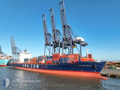
CMA CGM MONTOIR
Container Ship
Current Trip
| Trip Time | 4 days |
|---|---|
| Trip Distance | 48.50 nm |
| AVG Speed | 10.6 Noeuds |
| MAX Speed | 15.7 Noeuds |
| Tirant d eau | 8.5 m |
| AVG Wind | 20.1 knots |
| MAX Wind | 35.2 knots |
| MIN Temp | 14°C / 57.2°F |
| MAX Temp | 16.8°C / 62.24°F |
| Position reçue | 1 d depuis |
Current Position
| Longitude | 14.87605° |
|---|---|
| Latitude | 35.92807° |
| Etat | At anchor |
| Vitesse | 0.7 Noeuds |
| Parcours | 339° |
| Zone | Mediterranean Sea - Eastern Basin |
| Station | T-AIS |
| Position reçue | 1 d depuis |
Info
Information
The current position of CMA CGM MONTOIR is in Mediterranean Sea - Eastern Basin with coordinates 35.92807° / 14.87605° as reported on 2024-04-23 23:51 by AIS to our vessel tracker app. The vessel's current speed is 0.7 Noeuds and is currently inside the port of MARSAXLOKK.
The vessel CMA CGM MONTOIR (IMO: 9348443, MMSI: 229290000) is a Container Ship that was built in 2008 ( 16 Age ). It's sailing under the flag of [MT] Malta.
In this page you can find informations about the vessels current position, last detected port calls, and current voyage information. If the vessels is not in coverage by AIS you will find the latest position.
The current position of CMA CGM MONTOIR is detected by our AIS receivers and we are not responsible for the reliability of the data. The last position was recorded while the vessel was in Coverage by the Ais receivers of our vessel tracking app.
The current draught of CMA CGM MONTOIR as reported by AIS is 8.5 meters
Weather
| Temperature | 15°C / 59°F |
|---|---|
| Wind Speed | 17 knots |
| Direction | 305° NW |
| Pressure | 1013.8 hPa |
| Humidity | 58 % |
| Cloud Coverage | 97 % |
Featured Company
Last Port Calls
| Port | Arrival | Departure | Time In Port |
|---|---|---|---|
| 2024-04-24 03:23 | |||
| 2024-04-17 19:51 | 2024-04-19 05:53 | 1 d | |
| 2024-04-10 03:50 | 2024-04-11 00:20 | 20 h | |
| 2024-04-08 01:28 | 2024-04-09 17:16 | 1 d | |
| 2024-04-05 10:48 | 2024-04-06 19:25 | 1 d | |
| 2024-04-03 08:04 | 2024-04-04 11:52 | 1 d | |
| 2024-03-29 22:18 | 2024-03-31 00:57 | 1 d | |
| 2024-03-19 05:36 | 2024-03-19 17:21 | 11 h | |
| 2024-03-12 18:02 | 2024-03-13 10:33 | 16 h | |
| 2024-03-10 11:37 | 2024-03-12 06:06 | 1 d |
Most Visited Ports (Last year)
| Port | Arrivals | |
|---|---|---|
| 8 | ||
| 6 | ||
| 6 | ||
| 5 | ||
| 5 | ||
| 5 |
Last Trips
| Origin | Departure | Destination | Arrival | Distance | |
|---|---|---|---|---|---|
| 2024-04-19 07:53 | 2024-04-24 05:23 | 48.50 nm | |||
| 2024-04-11 02:20 | 2024-04-17 21:51 | 2481.95 nm | |||
| 2024-04-09 19:16 | 2024-04-10 05:50 | 120.79 nm | |||
| 2024-04-06 21:25 | 2024-04-08 03:28 | 411.19 nm | |||
| 2024-04-04 12:52 | 2024-04-05 12:48 | 381.96 nm | |||
| 2024-03-31 00:57 | 2024-04-03 09:04 | 1360.65 nm | |||
| 2024-03-19 18:21 | 2024-03-29 22:18 | 1312.80 nm | |||
| 2024-03-13 12:33 | 2024-03-19 06:36 | 1405.55 nm | |||
| 2024-03-12 09:06 | 2024-03-12 20:02 | 189.12 nm | |||
| 2024-03-10 05:13 | 2024-03-10 14:37 | 89.09 nm |
Events
| Heure | Evenement | Détails | Position/ Destination | Info |
|---|---|---|---|---|
| 2024-04-24 03:34 | Arret |
35.82023 / 14.53959
[MT] MARSAXLOKK
|
Vitesse: 0.2 kn Parcours: 137° |
|
| 2024-04-24 03:23 | Port d'arrivée |
|
35.82365 / 14.53675
[MT] MARSAXLOKK
|
Vitesse: 4.9 kn Parcours: 331° |
| 2024-04-24 01:03 | Démarrage | 16.6 nm, East of MARSAXLOKK |
35.92339 / 14.86450
MTMAR
|
Vitesse: 11.3 kn Parcours: 216° |
| 2024-04-23 23:52 | Etat Changé | Default At anchor |
35.92806 / 14.87605
MTMAR
|
Vitesse: 0.7 kn Parcours: 339° |
| 2024-04-23 23:51 | Etat Changé | At anchor Default |
35.92807 / 14.87605
MTMAR
|
Vitesse: 0.5 kn Parcours: 337° |
| 2024-04-23 23:51 | Hors de la zone couverte |
35.92807 / 14.87605
Mediterranean Sea - Eastern Basin
|
Vitesse: 0.7 kn Parcours: 234.6° |
|
| 2024-04-23 23:36 | Dans la zone couverte |
35.92807 / 14.87605
Mediterranean Sea - Eastern Basin
|
Vitesse: 0.7 kn Parcours: 234.6° |
|
| 2024-04-23 16:45 | Etat Changé | Default At anchor |
35.92882 / 14.87722
MTMAR
|
Vitesse: 0.4 kn Parcours: 321° |
| 2024-04-23 16:41 | Etat Changé | At anchor Default |
35.92890 / 14.87728
MTMAR
|
Vitesse: 0.1 kn Parcours: 316° |
| 2024-04-23 16:41 | Hors de la zone couverte |
35.92890 / 14.87728
Mediterranean Sea - Eastern Basin
|
Vitesse: 0.4 kn Parcours: 52.3° |