
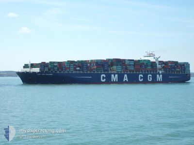
CMA CGM COLUMBA
Container Ship
Current Trip
| Time Travelled | 1 day |
|---|---|
| Remaining Time | --- |
| Distance Travelled | 156.26 nm |
| Remaining Distance | 16.59 nm |
| AVG Speed | 11.9 Noeuds |
| MAX Speed | 16 Noeuds |
| AVG Wind | 11.7 knots |
| MAX Wind | 17.9 knots |
| MIN Temp | 6.6°C / 43.88°F |
| MAX Temp | 10.1°C / 50.18°F |
| Tirant d eau | 14.3 m |
| Position reçue | 3 m depuis |
Current Position
| Longitude | -0.26410° |
|---|---|
| Latitude | 49.61800° |
| Etat | At anchor |
| Vitesse | |
| Parcours | 84° |
| Zone | English Channel |
| Station | T-AIS |
| Position reçue | 3 m depuis |
Info
Information
The current position of CMA CGM COLUMBA is in English Channel with coordinates 49.61800° / -0.26410° as reported on 2024-04-25 02:25 by AIS to our vessel tracker app. The vessel's current speed is 0 Noeuds and is heading at the port of LE HAVRE. The estimated time of arrival as calculated by MyShipTracking vessel tracking app is 2024-04-23 23:00 LT
The vessel CMA CGM COLUMBA (IMO: 9410789, MMSI: 215249000) is a Container Ship that was built in 2011 ( 13 Age ). It's sailing under the flag of [MT] Malta.
In this page you can find informations about the vessels current position, last detected port calls, and current voyage information. If the vessels is not in coverage by AIS you will find the latest position.
The current position of CMA CGM COLUMBA is detected by our AIS receivers and we are not responsible for the reliability of the data. The last position was recorded while the vessel was in Coverage by the Ais receivers of our vessel tracking app.
The current draught of CMA CGM COLUMBA as reported by AIS is 14.3 meters
Weather
| Temperature | 9.1°C / 48.38°F |
|---|---|
| Wind Speed | 3 knots |
| Direction | 203° SSW |
| Pressure | 1011.2 hPa |
| Humidity | 53.9 % |
| Cloud Coverage | 95 % |
Featured Company
Last Port Calls
| Port | Arrival | Departure | Time In Port |
|---|---|---|---|
| 2024-04-22 00:52 | 2024-04-23 10:47 | 1 d | |
| 2024-04-20 10:29 | 2024-04-21 12:30 | 1 d | |
| 2024-04-15 04:33 | 2024-04-18 04:30 | 2 d | |
| 2024-04-12 22:00 | 2024-04-14 10:03 | 1 d | |
| 2024-04-10 09:49 | 2024-04-11 02:01 | 16 h | |
| 2024-04-05 10:50 | 2024-04-06 05:42 | 18 h | |
| 2024-03-09 07:20 | 2024-03-10 17:01 | 1 d | |
| 2024-03-07 16:22 | |||
| 2024-02-28 08:32 | 2024-03-01 14:00 | 2 d | |
| 2024-02-04 14:27 | 2024-02-05 07:40 | 17 h |
Most Visited Ports (Last year)
| Port | Arrivals | |
|---|---|---|
| 8 | ||
| 8 | ||
| 8 | ||
| 7 | ||
| 6 | ||
| 6 |
Last Trips
| Origin | Departure | Destination | Arrival | Distance | |
|---|---|---|---|---|---|
| 2024-04-21 14:30 | 2024-04-22 02:52 | 140.29 nm | |||
| 2024-04-18 06:30 | 2024-04-20 12:29 | 231.54 nm | |||
| 2024-04-14 11:03 | 2024-04-15 06:33 | 269.99 nm | |||
| 2024-04-11 04:01 | 2024-04-12 23:00 | 497.46 nm | |||
| 2024-04-06 05:42 | 2024-04-10 11:49 | 1613.73 nm | |||
| 2024-03-10 22:31 | 2024-04-05 10:50 | 9852.01 nm | |||
| 2024-03-07 21:52 | 2024-03-09 12:50 | 423.73 nm | |||
| 2024-02-05 08:40 | 2024-02-28 12:32 | 10023.00 nm | |||
| 2024-02-01 03:51 | 2024-02-04 15:27 | 1251.18 nm |
Events
| Heure | Evenement | Détails | Position/ Destination | Info |
|---|---|---|---|---|
| 2024-04-24 19:19 | Etat Changé | At anchor Default |
49.61623 / -.25612
FRLEH
|
Vitesse: Parcours: -1° |
| 2024-04-24 19:17 | Etat Changé | Default At anchor |
49.61666 / -.25667
FRLEH
|
Vitesse: Parcours: 313° |
| 2024-04-24 15:07 | Etat Changé | At anchor Under way using engine |
49.61767 / -.26377
FRLEH
|
Vitesse: Parcours: 0° |
| 2024-04-24 15:04 | Etat Changé | Under way using engine At anchor |
49.61763 / -.26380
FRLEH
|
Vitesse: Parcours: 70° |
| 2024-04-24 13:56 | Changement d'ETA | 2024/04/25 10:00 2024/04/25 11:00 |
49.61798 / -.26377
FRLEH
|
Vitesse: Parcours: 78° |
| 2024-04-24 13:11 | Tirant d'eau modifié | 14.3 14.5 |
49.61812 / -.26370
FRLEH
|
Vitesse: Parcours: 81° |
| 2024-04-24 11:19 | Etat Changé | At anchor Default |
49.61575 / -.25743
FRLEH
|
Vitesse: 0.3 kn Parcours: 311° |
| 2024-04-24 11:16 | Etat Changé | Default At anchor |
49.61595 / -.25718
FRLEH
|
Vitesse: 0.2 kn Parcours: 307° |
| 2024-04-24 10:40 | Etat Changé | At anchor Under way using engine |
49.61747 / -.25598
FRLEH
|
Vitesse: Parcours: 0° |
| 2024-04-24 10:37 | Etat Changé | Under way using engine At anchor |
49.61757 / -.25595
FRLEH
|
Vitesse: Parcours: 284° |