
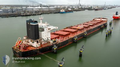
CAPE SANDRA
Bulk Carrier
Current Trip
TR IDM
| Time Travelled | 13 days |
|---|---|
| Remaining Time | --- |
| Distance Travelled | 3260.51 nm |
| Remaining Distance | --- |
| AVG Speed | 10.1 Noeuds |
| MAX Speed | 12.1 Noeuds |
| AVG Wind | 11.4 knots |
| MAX Wind | 34.7 knots |
| MIN Temp | 15.3°C / 59.54°F |
| MAX Temp | 29.7°C / 85.46°F |
| Tirant d eau | 17.5 m |
| Position reçue | 3 m depuis |
Current Position
| Longitude | -4.31073° |
|---|---|
| Latitude | 36.11262° |
| Etat | Under way using engine |
| Vitesse | 11.6 Noeuds |
| Parcours | 82° |
| Zone | Alboran Sea |
| Station | T-AIS |
| Position reçue | 3 m depuis |
Info
Information
The current position of CAPE SANDRA is in Alboran Sea with coordinates 36.11262° / -4.31073° as reported on 2024-04-20 01:49 by AIS to our vessel tracker app. The vessel's current speed is 11.6 Noeuds
The vessel CAPE SANDRA (IMO: 9446908, MMSI: 538004220) is a Bulk Carrier that was built in 2011 ( 13 Age ). It's sailing under the flag of [MH] Marshall Is.
In this page you can find informations about the vessels current position, last detected port calls, and current voyage information. If the vessels is not in coverage by AIS you will find the latest position.
The current position of CAPE SANDRA is detected by our AIS receivers and we are not responsible for the reliability of the data. The last position was recorded while the vessel was in Coverage by the Ais receivers of our vessel tracking app.
The current draught of CAPE SANDRA as reported by AIS is 17.5 meters
Weather
| Temperature | 16.7°C / 62.06°F |
|---|---|
| Wind Speed | 18 knots |
| Direction | 105° ESE |
| Pressure | 1015.4 hPa |
| Humidity | 67.7 % |
| Cloud Coverage | 100 % |
Featured Company
Events
| Heure | Evenement | Détails | Position/ Destination | Info |
|---|---|---|---|---|
| 2024-04-19 21:11 | Changement de zone | Spanish part of the Alboran Sea Spanish part of the Strait of Gibraltar |
35.98987 / -5.31205
Alboran Sea
TR IDM
|
Vitesse: 10.2 kn Parcours: 72° |
| 2024-04-19 20:53 | Changement de zone | Spanish part of the Strait of Gibraltar Moroccan part of the Strait of Gibraltar |
35.97497 / -5.37295
Strait of Gibraltar
TR IDM
|
Vitesse: 10.2 kn Parcours: 76° |
| 2024-04-19 19:17 | Etat Changé | Under way using engine Default |
35.90833 / -5.69498
TR IDM
|
Vitesse: 9.3 kn Parcours: 84° |
| 2024-04-19 19:14 | Etat Changé | Default Under way using engine |
35.90772 / -5.70282
TR IDM
|
Vitesse: 9.2 kn Parcours: 85° |
| 2024-04-19 19:03 | Etat Changé | Under way using engine Default |
35.90540 / -5.73762
TR IDM
|
Vitesse: 9.1 kn Parcours: 88° |
| 2024-04-19 19:03 | Etat Changé | Default Under way using engine |
35.90532 / -5.73972
TR IDM
|
Vitesse: 9.1 kn Parcours: 88° |
| 2024-04-19 18:56 | Etat Changé | Under way using engine Default |
35.90402 / -5.75882
TR IDM
|
Vitesse: 9.1 kn Parcours: 85° |
| 2024-04-19 18:38 | Etat Changé | Default Under way using engine |
35.89940 / -5.81552
TR IDM
|
Vitesse: 9.1 kn Parcours: 83° |
| 2024-04-19 18:31 | Changement de zone | Moroccan part of the Strait of Gibraltar Moroccan part of the North Atlantic Ocean |
35.89772 / -5.83837
Strait of Gibraltar
TR IDM
|
Vitesse: 9.1 kn Parcours: 83° |
| 2024-04-19 18:31 | Etat Changé | Under way using engine Default |
35.89772 / -5.83837
TR IDM
|
Vitesse: 9.2 kn Parcours: 83° |