
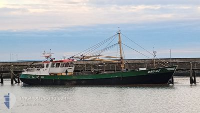
BRU23MATTHEUS
Fishing
Current Trip
| Trip Time | 2 days |
|---|---|
| Trip Distance | 136.87 nm |
| AVG Speed | 5.5 Noeuds |
| MAX Speed | 11.2 Noeuds |
| Tirant d eau | 1 m |
| AVG Wind | 18.6 knots |
| MAX Wind | 30.7 knots |
| MIN Temp | 7°C / 44.6°F |
| MAX Temp | 9.4°C / 48.92°F |
| Position reçue | Maintenant |
Current Position
| Longitude | 5.03158° |
|---|---|
| Latitude | 52.94008° |
| Etat | Under way using engine |
| Vitesse | |
| Parcours | 42° |
| Zone | North Sea |
| Station | T-AIS |
| Position reçue | Maintenant |
Info
Information
The current position of BRU23MATTHEUS is in North Sea with coordinates 52.94008° / 5.03158° as reported on 2024-04-18 03:25 by AIS to our vessel tracker app. The vessel's current speed is 0 Noeuds and is currently inside the port of DEN OEVER.
The vessel BRU23MATTHEUS (IMO: 8821840, MMSI: 244100331) is a Fishing It's sailing under the flag of [NL] Netherlands.
In this page you can find informations about the vessels current position, last detected port calls, and current voyage information. If the vessels is not in coverage by AIS you will find the latest position.
The current position of BRU23MATTHEUS is detected by our AIS receivers and we are not responsible for the reliability of the data. The last position was recorded while the vessel was in Coverage by the Ais receivers of our vessel tracking app.
The current draught of BRU23MATTHEUS as reported by AIS is 1 meters
Weather
| Temperature | 7.8°C / 46.04°F |
|---|---|
| Wind Speed | 16 knots |
| Direction | 4° N |
| Pressure | 1017 hPa |
| Humidity | 68.7 % |
| Cloud Coverage | 20 % |
Featured Company
Last Port Calls
| Port | Arrival | Departure | Time In Port |
|---|---|---|---|
| 2024-04-17 14:02 | |||
| 2024-04-10 12:32 | 2024-04-15 04:14 | 4 d | |
| 2024-04-08 17:18 | 2024-04-09 12:59 | 19 h | |
| 2024-04-07 22:03 | 2024-04-07 22:23 | 19 m | |
| 2024-03-20 08:05 | 2024-03-20 10:10 | 2 h | |
| 2024-03-19 06:12 | 2024-03-19 08:59 | 2 h | |
| 2024-03-04 07:11 | 2024-03-06 10:51 | 2 d |
Most Visited Ports (Last year)
| Port | Arrivals | |
|---|---|---|
| 12 | ||
| 10 | ||
| 9 | ||
| 9 | ||
| 8 | ||
| 3 |
Last Trips
| Origin | Departure | Destination | Arrival | Distance | |
|---|---|---|---|---|---|
| 2024-04-15 06:14 | 2024-04-17 16:02 | 136.87 nm | |||
| 2024-04-09 14:59 | 2024-04-10 14:32 | 59.75 nm | |||
| 2024-04-08 00:23 | 2024-04-08 19:18 | 139.83 nm | |||
| 2024-03-20 11:10 | 2024-04-08 00:03 | 163.24 nm | |||
| 2024-03-19 09:59 | 2024-03-20 09:05 | 27.79 nm | |||
| 2024-03-06 11:51 | 2024-03-19 07:12 | 145.08 nm | |||
| 2023-12-12 01:04 | 2024-03-04 08:11 | 303.22 nm |
Events
| Heure | Evenement | Détails | Position/ Destination | Info |
|---|---|---|---|---|
| 2024-04-17 14:42 | Arret |
52.94008 / 5.03155
[NL] DEN OEVER
|
Vitesse: 0.3 kn Parcours: 43° |
|
| 2024-04-17 14:34 | Démarrage |
52.93615 / 5.03541
[NL] DEN OEVER
|
Vitesse: 5.3 kn Parcours: 326° |
|
| 2024-04-17 14:02 | Arret |
52.93447 / 5.03713
[NL] DEN OEVER
|
Vitesse: 0.3 kn Parcours: 233° |
|
| 2024-04-17 14:02 | Port d'arrivée |
|
52.93450 / 5.03714
[NL] DEN OEVER
|
Vitesse: 0.8 kn Parcours: 225° |
| 2024-04-17 11:51 | Démarrage | 5.44 nm, South East of VLIELAND |
53.21379 / 5.14876
BRUINISSE
|
Vitesse: 8 kn Parcours: 114.1° |
| 2024-04-17 11:47 | Arret | 5.37 nm, South East of VLIELAND |
53.21425 / 5.14578
BRUINISSE
|
Vitesse: 0.3 kn Parcours: 51° |
| 2024-04-17 09:36 | Démarrage | 6.99 nm, North of DEN OEVER |
53.04979 / 5.08834
BRUINISSE
|
Vitesse: 3.9 kn Parcours: 56° |
| 2024-04-17 09:08 | Arret | 6.73 nm, North of DEN OEVER |
53.04594 / 5.08456
BRUINISSE
|
Vitesse: 0.1 kn Parcours: 339° |
| 2024-04-17 08:41 | Démarrage | 5.22 nm, North of DEN OEVER |
53.02074 / 5.07901
BRUINISSE
|
Vitesse: 5.1 kn Parcours: 78.7° |
| 2024-04-17 08:25 | Arret | 5.16 nm, North of DEN OEVER |
53.02023 / 5.07543
BRUINISSE
|
Vitesse: 0.3 kn Parcours: 237° |