
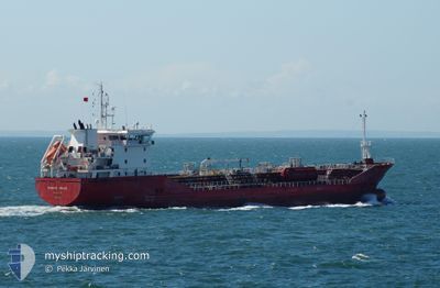
BOMAR VENUS
Oil/Chemical Tanker
Current Trip
FRFOS
| Time Travelled | 2 days |
|---|---|
| Remaining Time | --- |
| Distance Travelled | 9.12 nm |
| Remaining Distance | --- |
| AVG Speed | 5.5 Noeuds |
| MAX Speed | 7.7 Noeuds |
| AVG Wind | 21.9 knots |
| MAX Wind | 26.9 knots |
| MIN Temp | 6°C / 42.8°F |
| MAX Temp | 16.9°C / 62.42°F |
| Tirant d eau | 6.9 m |
| Position reçue | 4 d depuis |
Current Position
| Longitude | 4.99972° |
|---|---|
| Latitude | 43.14398° |
| Etat | Under way using engine |
| Vitesse | 10.2 Noeuds |
| Parcours | 30.5° |
| Zone | Mediterranean Sea - Western Basin |
| Station | T-AIS |
| Position reçue | 4 d depuis |
Info
Information
The current position of BOMAR VENUS is in Mediterranean Sea - Western Basin with coordinates 43.14398° / 4.99972° as reported on 2024-04-21 11:52 by AIS to our vessel tracker app. The vessel's current speed is 10.2 Noeuds
The vessel BOMAR VENUS (IMO: 9374014, MMSI: 215135000) is a Oil/Chemical Tanker that was built in 2006 ( 18 Age ). It's sailing under the flag of [MT] Malta.
In this page you can find informations about the vessels current position, last detected port calls, and current voyage information. If the vessels is not in coverage by AIS you will find the latest position.
The current position of BOMAR VENUS is detected by our AIS receivers and we are not responsible for the reliability of the data. The last position was recorded while the vessel was in Coverage by the Ais receivers of our vessel tracking app.
The current draught of BOMAR VENUS as reported by AIS is 6.9 meters
Weather
| Temperature | 13.6°C / 56.48°F |
|---|---|
| Wind Speed | 10 knots |
| Direction | 246° WSW |
| Pressure | 1008.4 hPa |
| Humidity | 64.8 % |
| Cloud Coverage | 100 % |
Featured Company
Last Port Calls
| Port | Arrival | Departure | Time In Port |
|---|---|---|---|
| 2024-04-21 13:48 | 2024-04-23 01:00 | 1 d | |
| 2024-04-15 05:41 | 2024-04-16 02:26 | 20 h | |
| 2024-04-11 00:28 | 2024-04-11 00:57 | 29 m | |
| 2024-04-05 21:38 | 2024-04-07 03:57 | 1 d | |
| 2024-04-02 16:49 | 2024-04-03 11:03 | 18 h | |
| 2024-04-01 16:40 | 2024-04-02 08:23 | 15 h | |
| 2024-03-26 23:19 | 2024-03-28 16:14 | 1 d | |
| 2024-03-25 12:31 | 2024-03-26 02:08 | 13 h | |
| 2024-03-20 13:40 | 2024-03-21 16:24 | 1 d | |
| 2024-03-17 10:55 | 2024-03-17 16:07 | 5 h |
Last Trips
| Origin | Departure | Destination | Arrival | Distance | |
|---|---|---|---|---|---|
| 2024-04-16 04:26 | 2024-04-21 15:48 | 1411.95 nm | |||
| 2024-04-11 02:57 | 2024-04-15 07:41 | 615.43 nm | |||
| 2024-04-07 05:57 | 2024-04-11 02:28 | 138.18 nm | |||
| 2024-04-03 11:03 | 2024-04-05 23:38 | 218.57 nm | |||
| 2024-04-02 08:23 | 2024-04-02 16:49 | 1.74 nm | |||
| 2024-03-28 17:14 | 2024-04-01 16:40 | 197.23 nm | |||
| 2024-03-26 03:08 | 2024-03-27 00:19 | 176.53 nm | |||
| 2024-03-21 17:24 | 2024-03-25 13:31 | 1046.78 nm | |||
| 2024-03-17 17:07 | 2024-03-20 14:40 | 867.52 nm | |||
| 2024-03-11 20:27 | 2024-03-17 11:55 | 1448.50 nm |
Events
| Heure | Evenement | Détails | Position/ Destination | Info |
|---|---|---|---|---|
| 2024-04-25 18:56 | Démarrage | 1.95 nm, East of FOS |
43.40386 / 4.93941
FRFOS
|
Vitesse: 4.2 kn Parcours: 156° |
| 2024-04-23 01:22 | Arret | 1.87 nm, West of PORT DE BOUC |
43.40236 / 4.94170
FRFOS
|
Vitesse: 0.2 kn Parcours: 306° |
| 2024-04-23 01:00 | PORT DE DEPART |
|
43.40002 / 4.93422
FRFOS
|
Vitesse: 12.3 kn Parcours: 95° |
| 2024-04-23 00:48 | Démarrage |
43.40796 / 4.88537
[FR] FOS
|
Vitesse: 11.8 kn Parcours: 156° |
|
| 2024-04-21 14:24 | Arret |
43.41539 / 4.88649
[FR] FOS
|
Vitesse: Parcours: 26° |
|
| 2024-04-21 13:48 | Port d'arrivée |
|
43.39731 / 4.91082
[FR] FOS
|
Vitesse: 10 kn Parcours: 287° |
| 2024-04-21 12:00 | Etat Changé | Default Under way using engine |
43.16412 / 5.01572
FRFOS
|
Vitesse: 10.2 kn Parcours: 30.5° |
| 2024-04-21 11:52 | Hors de la zone couverte |
43.14398 / 4.99972
Mediterranean Sea - Western Basin
|
Vitesse: 10.2 kn Parcours: 30.5° |
|
| 2024-04-21 11:51 | Etat Changé | Under way using engine Default |
43.14189 / 4.99800
FRFOS
|
Vitesse: 10.2 kn Parcours: 25° |
| 2024-04-21 11:36 | Etat Changé | Default Under way using engine |
43.10424 / 4.97109
FRFOS
|
Vitesse: 10.4 kn Parcours: 32.5° |