
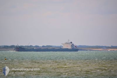
BLUE WAVE
Bulk Carrier
Current Trip
CNXIG
| Time Travelled | 22 days |
|---|---|
| Remaining Time | --- |
| Distance Travelled | 1639.32 nm |
| Remaining Distance | --- |
| AVG Speed | 9.2 Noeuds |
| MAX Speed | 13.4 Noeuds |
| AVG Wind | 11.9 knots |
| MAX Wind | 32 knots |
| MIN Temp | 4.6°C / 40.28°F |
| MAX Temp | 19.6°C / 67.28°F |
| Tirant d eau | 14.5 m |
| Position reçue | 13 d depuis |
Current Position
| Longitude | 123.91990° |
|---|---|
| Latitude | 36.19512° |
| Etat | Under way using engine |
| Vitesse | 11.1 Noeuds |
| Parcours | 159° |
| Zone | Yellow Sea |
| Station | T-AIS |
| Position reçue | 13 d depuis |
Info
Information
The current position of BLUE WAVE is in Yellow Sea with coordinates 36.19512° / 123.91990° as reported on 2024-04-07 00:11 by AIS to our vessel tracker app. The vessel's current speed is 11.1 Noeuds
The vessel BLUE WAVE (IMO: 9453377, MMSI: 209722000) is a Bulk Carrier that was built in 2011 ( 13 Age ). It's sailing under the flag of [CY] Cyprus.
In this page you can find informations about the vessels current position, last detected port calls, and current voyage information. If the vessels is not in coverage by AIS you will find the latest position.
The current position of BLUE WAVE is detected by our AIS receivers and we are not responsible for the reliability of the data. The last position was recorded while the vessel was in Coverage by the Ais receivers of our vessel tracking app.
The current draught of BLUE WAVE as reported by AIS is 14.5 meters
Weather
| Temperature | 18.7°C / 65.66°F |
|---|---|
| Wind Speed | 27 knots |
| Direction | 172° S |
| Pressure | 1008.2 hPa |
| Humidity | 89.8 % |
| Cloud Coverage | 100 % |
Featured Company
Events
| Heure | Evenement | Détails | Position/ Destination | Info |
|---|---|---|---|---|
| 2024-04-20 03:30 | Démarrage |
32.25478 / 127.40832
CNXIG
|
Vitesse: 3.6 kn Parcours: 143° |
|
| 2024-04-16 11:21 | Arret |
31.81833 / 127.82667
CNXIG
|
Vitesse: Parcours: -1° |
|
| 2024-04-16 09:02 | Démarrage |
32.07030 / 127.88944
CNXIG
|
Vitesse: 7.1 kn Parcours: 183° |
|
| 2024-04-15 11:23 | Arret |
31.77500 / 127.86334
CNXIG
|
Vitesse: Parcours: -1° |
|
| 2024-04-14 17:44 | Démarrage |
32.38667 / 127.47166
CNXIG
|
Vitesse: 5 kn Parcours: 162° |
|
| 2024-04-14 06:02 | Arret |
32.12167 / 127.59333
CNXIG
|
Vitesse: Parcours: -1° |
|
| 2024-04-14 04:02 | Démarrage |
32.26187 / 127.41067
CNXIG
|
Vitesse: 4.5 kn Parcours: 129° |
|
| 2024-04-12 12:32 | Arret |
31.71333 / 127.88500
CNXIG
|
Vitesse: Parcours: -1° |
|
| 2024-04-12 10:08 | Démarrage |
31.88500 / 127.61667
CNXIG
|
Vitesse: 5 kn Parcours: 115° |
|
| 2024-04-11 00:41 | Arret |
31.69333 / 127.93500
CNXIG
|
Vitesse: Parcours: -1° |