
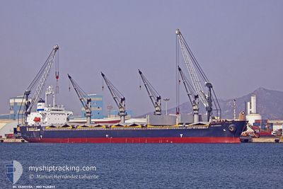
BC VANESSA
Bulk Carrier
Current Trip
| Time Travelled | 17 days |
|---|---|
| Remaining Time | --- |
| Distance Travelled | 3927.95 nm |
| Remaining Distance | --- |
| AVG Speed | 10.7 Noeuds |
| MAX Speed | 13.7 Noeuds |
| AVG Wind | 7.9 knots |
| MAX Wind | 18 knots |
| MIN Temp | 21.9°C / 71.42°F |
| MAX Temp | 32.5°C / 90.5°F |
| Tirant d eau | 10.8 m |
| Position reçue | 2 d depuis |
Current Position
| Longitude | 105.52290° |
|---|---|
| Latitude | 1.84180° |
| Etat | Under way using engine |
| Vitesse | 12.6 Noeuds |
| Parcours | 68° |
| Zone | South China Sea |
| Station | T-AIS |
| Position reçue | 2 d depuis |
Info
Information
The current position of BC VANESSA is in South China Sea with coordinates 1.84180° / 105.52290° as reported on 2024-04-16 22:27 by AIS to our vessel tracker app. The vessel's current speed is 12.6 Noeuds
The vessel BC VANESSA (IMO: 9426855, MMSI: 314531000) is a Bulk Carrier that was built in 2010 ( 14 Age ). It's sailing under the flag of [BB] Barbados.
In this page you can find informations about the vessels current position, last detected port calls, and current voyage information. If the vessels is not in coverage by AIS you will find the latest position.
The current position of BC VANESSA is detected by our AIS receivers and we are not responsible for the reliability of the data. The last position was recorded while the vessel was in Coverage by the Ais receivers of our vessel tracking app.
The current draught of BC VANESSA as reported by AIS is 10.8 meters
Weather
| Temperature | 28.8°C / 83.84°F |
|---|---|
| Wind Speed | 4 knots |
| Direction | 352° N |
| Pressure | 1009.2 hPa |
| Humidity | 70.6 % |
| Cloud Coverage | 100 % |
Featured Company
Last Port Calls
| Port | Arrival | Departure | Time In Port |
|---|---|---|---|
| 2024-03-13 04:43 | 2024-04-01 23:46 | 19 d | |
| 2024-02-24 23:25 | 2024-03-07 03:10 | 11 d | |
| 2024-02-04 09:03 |
Most Visited Ports (Last year)
| Port | Arrivals | |
|---|---|---|
| 1 | ||
| 1 | ||
| 1 | ||
| 1 | ||
| 1 | ||
| 1 |
Last Trips
| Origin | Departure | Destination | Arrival | Distance | |
|---|---|---|---|---|---|
| 2024-03-07 07:10 | 2024-03-13 07:43 | 389.27 nm | |||
| 2024-02-04 12:03 | 2024-02-25 03:25 | 1670.60 nm |
Events
| Heure | Evenement | Détails | Position/ Destination | Info |
|---|---|---|---|---|
| 2024-04-16 22:35 | Etat Changé | Default Under way using engine |
1.85217 / 105.54829
SAMALAJU
|
Vitesse: 12.6 kn Parcours: 68° |
| 2024-04-16 22:27 | Hors de la zone couverte |
1.84180 / 105.52290
South China Sea
SAMALAJU
|
Vitesse: 12.6 kn Parcours: 68° |
|
| 2024-04-16 18:57 | Tirant d'eau modifié | 10.8 10.7 |
1.56068 / 104.84598
SAMALAJU
|
Vitesse: 12.3 kn Parcours: 68° |
| 2024-04-16 18:52 | Etat Changé | Under way using engine Default |
1.55477 / 104.83100
SAMALAJU
|
Vitesse: 12.3 kn Parcours: 68° |
| 2024-04-16 18:47 | Etat Changé | Default Under way using engine |
1.54820 / 104.81457
SAMALAJU
|
Vitesse: 12.2 kn Parcours: 68° |
| 2024-04-16 18:42 | Changement de zone | Indonesian part of the South China Sea Malaysian part of the Singapore Strait |
1.54153 / 104.79808
South China Sea
SAMALAJU
|
Vitesse: 12.2 kn Parcours: 68° |
| 2024-04-16 18:42 | Etat Changé | Under way using engine Default |
1.54153 / 104.79808
SAMALAJU
|
Vitesse: 12.2 kn Parcours: 69° |
| 2024-04-16 18:27 | Dans la zone couverte |
1.54153 / 104.79808
South China Sea
SAMALAJU
|
Vitesse: 12.2 kn Parcours: 68° |
|
| 2024-04-16 16:11 | Etat Changé | Default Under way using engine |
1.31498 / 104.36567
SAMALAJU
|
Vitesse: 10.6 kn Parcours: 55° |
| 2024-04-16 16:08 | Hors de la zone couverte |
1.30863 / 104.35738
Singapore Strait
SAMALAJU
|
Vitesse: 10.6 kn Parcours: 55° |