
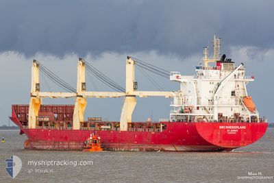
BBC RHEIDERLAND
General Cargo
Current Trip
| Time Travelled | 2 days |
|---|---|
| Remaining Time | 4 days |
| Distance Travelled | 803.11 nm |
| Remaining Distance | 1452.61 nm |
| AVG Speed | 13.6 Noeuds |
| MAX Speed | 15 Noeuds |
| AVG Wind | 11.4 knots |
| MAX Wind | 21.9 knots |
| MIN Temp | 21.3°C / 70.34°F |
| MAX Temp | 27.3°C / 81.14°F |
| Tirant d eau | 7.6 m |
| Position reçue | 2 d depuis |
Current Position
| Longitude | -97.53470° |
|---|---|
| Latitude | 22.46026° |
| Etat | Under way using engine |
| Vitesse | 13.3 Noeuds |
| Parcours | 89° |
| Zone | Gulf of Mexico |
| Station | T-AIS |
| Position reçue | 2 d depuis |
Info
Information
The current position of BBC RHEIDERLAND is in Gulf of Mexico with coordinates 22.46026° / -97.53470° as reported on 2024-04-22 20:04 by AIS to our vessel tracker app. The vessel's current speed is 13.3 Noeuds and is heading at the port of POINT LISAS. The estimated time of arrival as calculated by MyShipTracking vessel tracking app is 2024-04-29 11:42 LT
The vessel BBC RHEIDERLAND (IMO: 9614696, MMSI: 305276000) is a General Cargo that was built in 2013 ( 11 Age ). It's sailing under the flag of [AG] Antigua Barbuda.
In this page you can find informations about the vessels current position, last detected port calls, and current voyage information. If the vessels is not in coverage by AIS you will find the latest position.
The current position of BBC RHEIDERLAND is detected by our AIS receivers and we are not responsible for the reliability of the data. The last position was recorded while the vessel was in Coverage by the Ais receivers of our vessel tracking app.
The current draught of BBC RHEIDERLAND as reported by AIS is 7.6 meters
Weather
| Temperature | 26.7°C / 80.06°F |
|---|---|
| Wind Speed | 9 knots |
| Direction | 48° NE |
| Pressure | 1017.3 hPa |
| Humidity | 72.8 % |
| Cloud Coverage | --- |
Featured Company
Last Port Calls
| Port | Arrival | Departure | Time In Port |
|---|---|---|---|
| 2024-04-21 14:15 | 2024-04-22 18:41 | 1 d | |
| 2024-04-19 03:49 | 2024-04-20 15:54 | 1 d | |
| 2024-04-01 15:23 | 2024-04-08 00:02 | 6 d | |
| 2024-03-13 20:45 | 2024-03-15 14:28 | 1 d | |
| 2024-03-10 05:50 | |||
| 2024-02-15 06:21 | 2024-02-23 07:41 | 8 d | |
| 2024-02-12 14:14 | 2024-02-13 13:47 | 23 h | |
| 2024-02-01 18:52 | 2024-02-02 03:28 | 8 h |
Most Visited Ports (Last year)
| Port | Arrivals | |
|---|---|---|
| 3 | ||
| 3 | ||
| 2 | ||
| 2 | ||
| 2 | ||
| 2 |
Last Trips
| Origin | Departure | Destination | Arrival | Distance | |
|---|---|---|---|---|---|
| 2024-04-20 10:54 | 2024-04-21 09:15 | 253.53 nm | |||
| 2024-04-07 19:02 | 2024-04-18 22:49 | 346.84 nm | |||
| 2024-03-15 15:28 | 2024-04-01 10:23 | 5616.83 nm | |||
| 2024-03-10 06:50 | 2024-03-13 21:45 | 676.72 nm | |||
| 2024-02-13 14:47 | 2024-02-15 07:21 | 527.14 nm | |||
| 2024-02-01 22:28 | 2024-02-12 15:14 | 3621.19 nm | |||
| 2024-01-23 16:20 | 2024-02-01 13:52 | 1624.57 nm |
Events
| Heure | Evenement | Détails | Position/ Destination | Info |
|---|---|---|---|---|
| 2024-04-22 20:05 | Etat Changé | Default Under way using engine |
22.46014 / -97.52927
TTPTS
|
Vitesse: 13.3 kn Parcours: 89° |
| 2024-04-22 20:04 | Hors de la zone couverte |
22.46026 / -97.53470
Gulf of Mexico
TTPTS
|
Vitesse: 13.3 kn Parcours: 89° |
|
| 2024-04-22 18:41 | PORT DE DEPART |
|
22.48743 / -97.85653
TTPTS
|
Vitesse: 7 kn Parcours: 90° |
| 2024-04-22 18:20 | Démarrage |
22.50136 / -97.88708
[MX] ALTAMIRA
|
Vitesse: 3.4 kn Parcours: 170° |
|
| 2024-04-22 18:20 | Changement de destination | TTPTS MX ATM |
22.50170 / -97.88717
[MX] ALTAMIRA
|
Vitesse: 3.1 kn Parcours: 170° |
| 2024-04-22 18:20 | Changement d'ETA | 2024/04/28 18:00 2024/04/21 06:00 |
22.50170 / -97.88717
[MX] ALTAMIRA
|
Vitesse: 3.1 kn Parcours: 170° |
| 2024-04-22 18:19 | Etat Changé | Under way using engine Moored |
22.50195 / -97.88729
[MX] ALTAMIRA
|
Vitesse: 2.3 kn Parcours: 159° |
| 2024-04-21 22:22 | Etat Changé | Moored Under way using engine |
22.50294 / -97.88869
[MX] ALTAMIRA
|
Vitesse: Parcours: 173° |
| 2024-04-21 15:13 | Arret |
22.50291 / -97.88820
[MX] ALTAMIRA
|
Vitesse: 0.3 kn Parcours: 169° |
|
| 2024-04-21 14:15 | Port d'arrivée |
|
22.48734 / -97.85836
[MX] ALTAMIRA
|
Vitesse: 7.8 kn Parcours: 271.1° |