
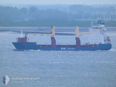
BBC GDANSK
General Cargo
Current Trip
IDBEN
| Time Travelled | 4 days |
|---|---|
| Remaining Time | --- |
| Distance Travelled | 687.08 nm |
| Remaining Distance | --- |
| AVG Speed | 10.6 Noeuds |
| MAX Speed | 14 Noeuds |
| AVG Wind | 6.5 knots |
| MAX Wind | 14.9 knots |
| MIN Temp | 23.2°C / 73.76°F |
| MAX Temp | 29.9°C / 85.82°F |
| Tirant d eau | 6 m |
| Position reçue | 10 d depuis |
Current Position
| Longitude | 104.33298° |
|---|---|
| Latitude | 1.28597° |
| Etat | Under way using engine |
| Vitesse | 10.2 Noeuds |
| Parcours | 53.5° |
| Zone | Singapore Strait |
| Station | T-AIS |
| Position reçue | 10 d depuis |
Info
Information
The current position of BBC GDANSK is in Singapore Strait with coordinates 1.28597° / 104.33298° as reported on 2024-04-13 06:33 by AIS to our vessel tracker app. The vessel's current speed is 10.2 Noeuds
The vessel BBC GDANSK (IMO: 9436965, MMSI: 305372000) is a General Cargo that was built in 2009 ( 15 Age ). It's sailing under the flag of [AG] Antigua Barbuda.
In this page you can find informations about the vessels current position, last detected port calls, and current voyage information. If the vessels is not in coverage by AIS you will find the latest position.
The current position of BBC GDANSK is detected by our AIS receivers and we are not responsible for the reliability of the data. The last position was recorded while the vessel was in Coverage by the Ais receivers of our vessel tracking app.
The current draught of BBC GDANSK as reported by AIS is 6 meters
Weather
| Temperature | 28.2°C / 82.76°F |
|---|---|
| Wind Speed | 4 knots |
| Direction | 132° SE |
| Pressure | 1006.9 hPa |
| Humidity | 77.6 % |
| Cloud Coverage | 100 % |
Featured Company
Last Port Calls
| Port | Arrival | Departure | Time In Port |
|---|---|---|---|
| 2024-04-17 05:53 | 2024-04-19 12:25 | 2 d | |
| 2024-04-11 05:13 | 2024-04-12 12:01 | 1 d | |
| 2024-03-19 07:57 | 2024-03-19 16:06 | 8 h | |
| 2024-02-21 21:16 | 2024-02-22 20:23 | 23 h | |
| 2024-02-04 16:02 | 2024-02-07 21:46 | 3 d | |
| 2024-02-02 02:54 | 2024-02-03 00:08 | 21 h | |
| 2024-02-01 12:54 | 2024-02-01 14:37 | 1 h |
Most Visited Ports (Last year)
| Port | Arrivals | |
|---|---|---|
| 18 | ||
| 16 | ||
| 15 | ||
| 15 | ||
| 14 | ||
| 14 |
Last Trips
| Origin | Departure | Destination | Arrival | Distance | |
|---|---|---|---|---|---|
| 2024-04-12 20:01 | 2024-04-17 13:53 | 1046.65 nm | |||
| 2024-03-19 18:06 | 2024-04-11 13:13 | 5930.53 nm | |||
| 2024-02-22 23:23 | 2024-03-19 09:57 | 7042.41 nm | |||
| 2024-02-07 22:46 | 2024-02-22 00:16 | 3318.72 nm | |||
| 2024-02-03 01:08 | 2024-02-04 17:02 | 381.40 nm | |||
| 2024-02-01 15:37 | 2024-02-02 03:54 | 88.55 nm | |||
| 2024-01-30 16:48 | 2024-02-01 13:54 | 465.62 nm |
Events
| Heure | Evenement | Détails | Position/ Destination | Info |
|---|---|---|---|---|
| 2024-04-22 05:35 | Arret | 6.17 nm, North East of JAKARTA |
-6.01745 / 106.90627
IDBEN
|
Vitesse: 0.2 kn Parcours: 107° |
| 2024-04-19 12:25 | PORT DE DEPART |
|
-8.71616 / 116.69110
IDBEN
|
Vitesse: Parcours: -1° |
| 2024-04-17 06:07 | Arret |
-8.89754 / 116.74721
[ID] BENETE
|
Vitesse: Parcours: 318° |
|
| 2024-04-17 05:53 | Port d'arrivée |
|
-8.89167 / 116.74333
[ID] BENETE
|
Vitesse: 6.2 kn Parcours: 121° |
| 2024-04-17 04:43 | Démarrage | 2.43 nm, North of BENETE |
-8.85272 / 116.74084
IDBEN
|
Vitesse: 4.3 kn Parcours: 284° |
| 2024-04-16 10:30 | Arret | 2.29 nm, North of BENETE |
-8.85518 / 116.73997
IDBEN
|
Vitesse: 0.2 kn Parcours: 45° |