
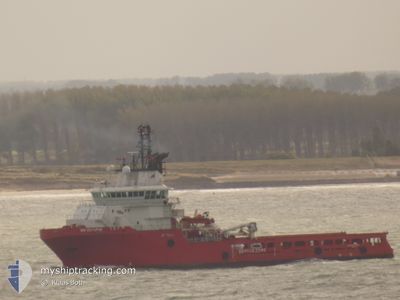
BB OCTOPUS
Anchor Handling Vessel
Current Trip
PENGUINS FIELD
| Time Travelled | 2 days |
|---|---|
| Remaining Time | --- |
| Distance Travelled | 178.69 nm |
| Remaining Distance | --- |
| AVG Speed | 10.4 Noeuds |
| MAX Speed | 11.5 Noeuds |
| AVG Wind | 13.5 knots |
| MAX Wind | 23 knots |
| MIN Temp | 4.1°C / 39.38°F |
| MAX Temp | 6.5°C / 43.7°F |
| Tirant d eau | 6.6 m |
| Position reçue | 12 h, 47 m depuis |
Current Position
| Longitude | 1.40582° |
|---|---|
| Latitude | 61.57736° |
| Etat | Under way using engine |
| Vitesse | 2.7 Noeuds |
| Parcours | 64° |
| Zone | Norwegian Sea |
| Station | T-AIS |
| Position reçue | 12 h, 47 m depuis |
Info
Information
The current position of BB OCTOPUS is in Norwegian Sea with coordinates 61.57736° / 1.40582° as reported on 2024-04-18 04:20 by AIS to our vessel tracker app. The vessel's current speed is 2.7 Noeuds
The vessel BB OCTOPUS (IMO: 9355771, MMSI: 258184000) is a Anchor Handling Vessel that was built in 2006 ( 18 Age ). It's sailing under the flag of [NO] Norway.
In this page you can find informations about the vessels current position, last detected port calls, and current voyage information. If the vessels is not in coverage by AIS you will find the latest position.
The current position of BB OCTOPUS is detected by our AIS receivers and we are not responsible for the reliability of the data. The last position was recorded while the vessel was in Coverage by the Ais receivers of our vessel tracking app.
The current draught of BB OCTOPUS as reported by AIS is 6.6 meters
Weather
| Temperature | 6.2°C / 43.16°F |
|---|---|
| Wind Speed | 13 knots |
| Direction | 201° SSW |
| Pressure | 1012.5 hPa |
| Humidity | 66.8 % |
| Cloud Coverage | 100 % |
Featured Company
Last Port Calls
| Port | Arrival | Departure | Time In Port |
|---|---|---|---|
| 2024-03-29 11:08 | 2024-04-16 05:17 | 17 d | |
| 2024-03-10 13:13 | 2024-03-10 13:46 | 33 m | |
| 2024-03-08 02:32 | 2024-03-09 01:17 | 22 h | |
| 2024-02-27 16:34 | 2024-02-28 03:33 | 10 h | |
| 2024-02-17 08:10 | 2024-02-27 03:07 | 9 d | |
| 2024-02-11 03:28 |
Last Trips
| Origin | Departure | Destination | Arrival | Distance | |
|---|---|---|---|---|---|
| 2024-03-10 13:46 | 2024-03-29 11:08 | 318.83 nm | |||
| 2024-03-09 01:17 | 2024-03-10 13:13 | 153.19 nm | |||
| 2024-02-28 03:33 | 2024-03-08 02:32 | 599.72 nm | |||
| 2024-02-27 03:07 | 2024-02-27 16:34 | 8.36 nm | |||
| 2024-02-11 03:28 | 2024-02-17 08:10 | 500.53 nm |
Events
| Heure | Evenement | Détails | Position/ Destination | Info |
|---|---|---|---|---|
| 2024-04-18 04:23 | Etat Changé | Default Under way using engine |
61.57862 / 1.41001
PENGUINS FIELD
|
Vitesse: 2.7 kn Parcours: 64° |
| 2024-04-18 04:20 | Etat Changé | Under way using engine Default |
61.57736 / 1.40582
PENGUINS FIELD
|
Vitesse: 1 kn Parcours: -1° |
| 2024-04-18 04:20 | Hors de la zone couverte |
61.57736 / 1.40582
Norwegian Sea
|
Vitesse: 2.7 kn Parcours: 55.8° |
|
| 2024-04-18 04:06 | Dans la zone couverte |
61.57736 / 1.40582
Norwegian Sea
|
Vitesse: 2.7 kn Parcours: 55.8° |
|
| 2024-04-17 18:18 | Démarrage |
61.58062 / 1.42430
PENGUINS FIELD
|
Vitesse: 3.1 kn Parcours: 219° |
|
| 2024-04-17 14:23 | Etat Changé | Default Under way using engine |
61.59401 / 1.46162
PENGUINS FIELD
|
Vitesse: 1.8 kn Parcours: 55° |
| 2024-04-17 14:20 | Etat Changé | Under way using engine Default |
61.59307 / 1.45919
PENGUINS FIELD
|
Vitesse: 1.5 kn Parcours: 59° |
| 2024-04-17 14:20 | Hors de la zone couverte |
61.59307 / 1.45919
Norwegian Sea
|
Vitesse: 1.8 kn Parcours: 50.8° |
|
| 2024-04-17 14:08 | Dans la zone couverte |
61.59307 / 1.45919
Norwegian Sea
|
Vitesse: 1.8 kn Parcours: 50.8° |
|
| 2024-04-17 03:20 | Hors de la zone couverte |
61.55043 / 1.42329
Norwegian Sea
|
Vitesse: 1.1 kn Parcours: 63.2° |